File:1862 Johnson Diagram of the World Time Zones from Washington - Geographicus - Diagram-johnson-1862.jpg
Jump to navigation
Jump to search
Size of this preview: 511 × 599 pixels. Other resolutions: 205 × 240 pixels | 409 × 480 pixels | 655 × 768 pixels | 873 × 1,024 pixels | 1,746 × 2,048 pixels | 2,984 × 3,500 pixels.
Original file (2,984 × 3,500 pixels, file size: 2.2 MB, MIME type: image/jpeg)
Captions
Captions
Add a one-line explanation of what this file represents
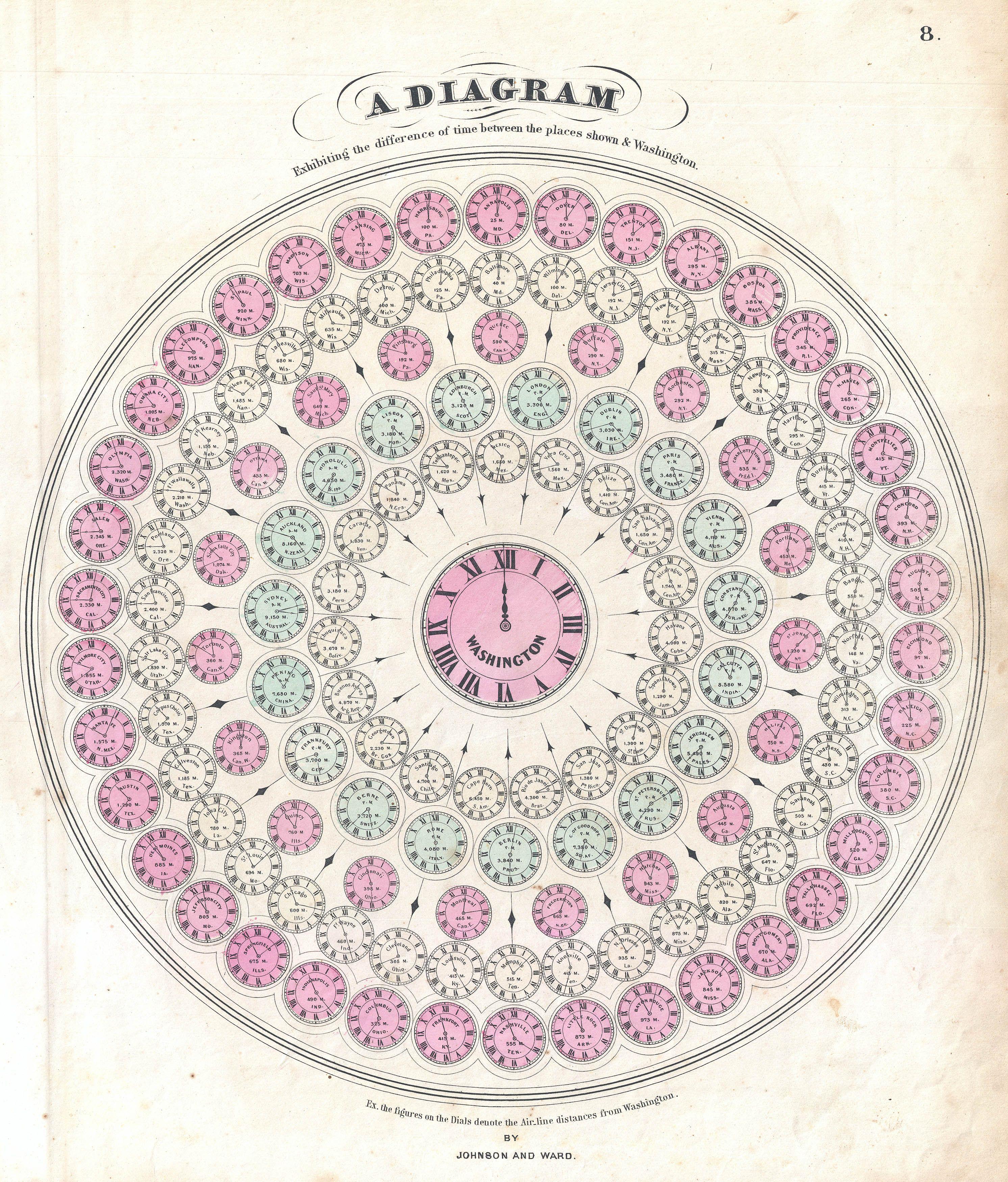
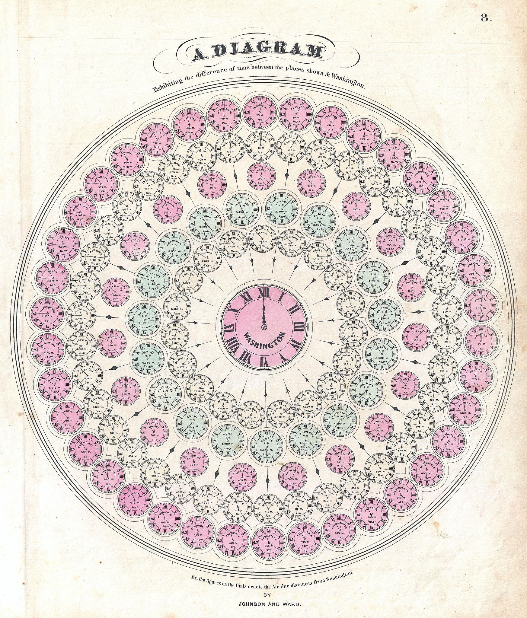
| Alvin Jewett Johnson: A Diagram Exhibiting the difference of time between the places shown & Washington.
( |
|||||||||||||||||||||||
|---|---|---|---|---|---|---|---|---|---|---|---|---|---|---|---|---|---|---|---|---|---|---|---|
| Artist |
|
||||||||||||||||||||||
| Title |
A Diagram Exhibiting the difference of time between the places shown & Washington. |
||||||||||||||||||||||
| Description |
English: A very attractive example of Johnson's 1862 diagram of the world's time zones. Consists of a circular engraving in which numerous clocks are drawn, each representing a major world city. At the center is clock representing the time in Washington, D.C. The time in Washington is set at 12 and the remaining clock are adjusted accordingly So, if it is 12 in Washington, it is 11:02 in Calcutta and 6:35 in Honolulu, etc. Published by A. J. Johnson and Ward as plate number 8 in the 1862 edition of Johnson’s New Illustrated Family Atlas . This is the first edition of the Family Atlas to bear the Johnson and Ward imprint. |
||||||||||||||||||||||
| Date | 1862 (undated) | ||||||||||||||||||||||
| Dimensions | height: 16 in (40.6 cm); width: 13.5 in (34.2 cm) | ||||||||||||||||||||||
| Accession number |
Geographicus link: Diagram-johnson-1862 |
||||||||||||||||||||||
| Source/Photographer |
Johnson, A. J., Johnson's New Illustrated (Steel Plate) Family Atlas with Descriptions, Geographical, Statistical, and Historical. (1862 A. J. Johnson & Ward edition)
|
||||||||||||||||||||||
| Permission (Reusing this file) |
|
||||||||||||||||||||||
File history
Click on a date/time to view the file as it appeared at that time.
| Date/Time | Thumbnail | Dimensions | User | Comment | |
|---|---|---|---|---|---|
| current | 00:47, 23 March 2011 | | 2,984 × 3,500 (2.2 MB) | BotMultichillT (talk | contribs) | {{subst:User:Multichill/Geographicus |link=http://www.geographicus.com/P/AntiqueMap/Diagram-johnson-1862 |product_name=1862 Johnson Diagram of the World Time Zones from Washington |map_title=A Diagram Exhibiting the difference of time between the places s |
You cannot overwrite this file.
File usage on Commons
The following 2 pages use this file:
File usage on other wikis
The following other wikis use this file:
- Usage on cs.wikipedia.org
- Usage on nl.wikipedia.org