File:1861 Levasseur Map of Corsica ( La Corse ), France - Geographicus - Corsica-levasseur-1861.jpg
Jump to navigation
Jump to search
Size of this preview: 412 × 600 pixels. Other resolutions: 165 × 240 pixels | 330 × 480 pixels | 527 × 768 pixels | 703 × 1,024 pixels | 2,404 × 3,500 pixels.
Original file (2,404 × 3,500 pixels, file size: 3.01 MB, MIME type: image/jpeg)
Captions
Captions
Add a one-line explanation of what this file represents
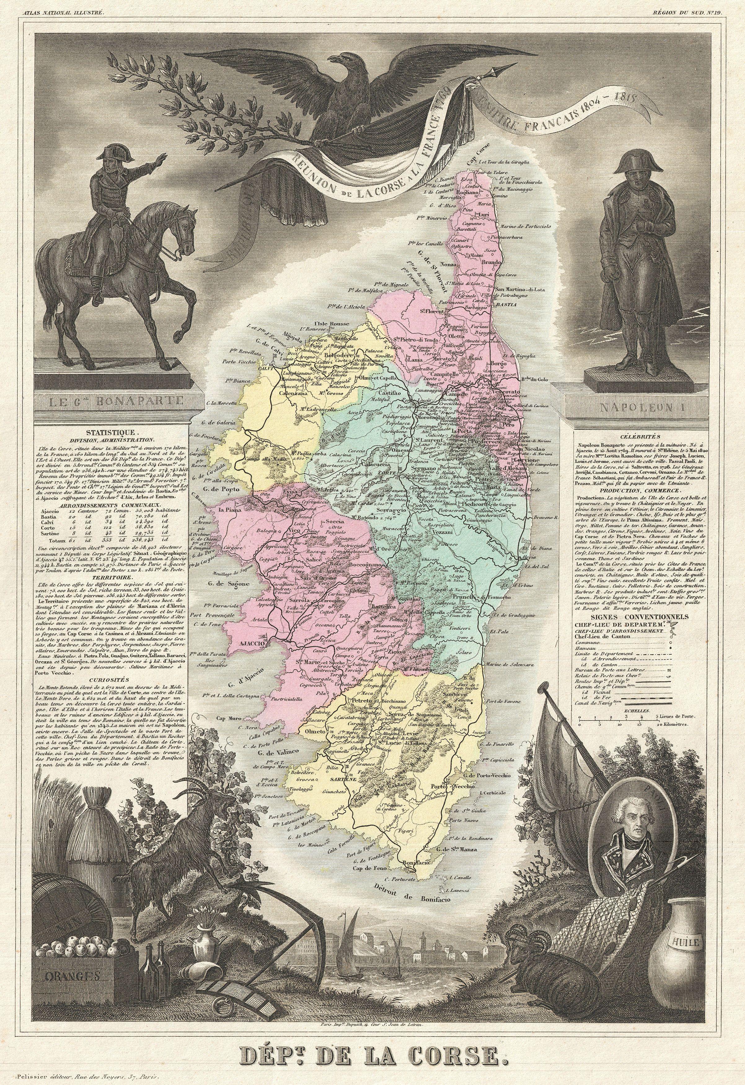
| Dept. de la Corse. | ||||||||||||||||||||||||||||||||||||
|---|---|---|---|---|---|---|---|---|---|---|---|---|---|---|---|---|---|---|---|---|---|---|---|---|---|---|---|---|---|---|---|---|---|---|---|---|
| Artist |
|
|||||||||||||||||||||||||||||||||||
| Title |
Dept. de la Corse. |
|||||||||||||||||||||||||||||||||||
| Description |
English: A visually stunning decorative map of Corsica (La Corse) dating to 1861, by French map publisher Victor Levasseur. Levasseur published several different editions of his Corsica map - this being a later state The island of Corsica is drawn inconsiderable detail showing its many forests, roadways, cities, and three primary districts. By bar this map's most striking feature is its elaborate allegorical border work. Levasseur composed this map for publication in his magnificent Atlas Nacionale de la France Illustree , one of the most decorative and beautifully produced atlases to appear in the 19th century. This particular map is surrounded on all sides with elaborate illustrative border work showing the cultural, natural, and trade richness of Corsica. Napoleon Bonaparte, Corsica's most celebrated son, appears in the upper right and left quadrants with a great imperial eagle at top center. Pascal Paoli appears in the lower right corner. The remainder of the decorative border work is given to displaying the the many products of Corsica, including Goats, honey, wines, distilled spirits, seafood, cheese, and sardines. Publised by V. Levasseur in the 1861 edition of his Atlas National de la France Illustree. |
|||||||||||||||||||||||||||||||||||
| Date | 1861 (undated) | |||||||||||||||||||||||||||||||||||
| Dimensions | height: 16.5 in (41.9 cm); width: 12.5 in (31.7 cm) | |||||||||||||||||||||||||||||||||||
| Accession number |
Geographicus link: Corsica-levasseur-1861 |
|||||||||||||||||||||||||||||||||||
| Source/Photographer |
Levassuer, V., Atlas National Illustre des 86 Departements et des Possessions de La France Divise par Arrondissements, Cantons et Communea avec La Trace de Toutes Les Routes, Chemins,de fer et Canaux., 1852 edition.
|
|||||||||||||||||||||||||||||||||||
| Permission (Reusing this file) |
|
|||||||||||||||||||||||||||||||||||
File history
Click on a date/time to view the file as it appeared at that time.
| Date/Time | Thumbnail | Dimensions | User | Comment | |
|---|---|---|---|---|---|
| current | 00:37, 25 March 2011 | | 2,404 × 3,500 (3.01 MB) | BotMultichillT (talk | contribs) | {{subst:User:Multichill/Geographicus |link=http://www.geographicus.com/P/AntiqueMap/Corsica-levasseur-1861 |product_name=1861 Levasseur Map of Corsica ( La Corse ), France |map_title=Dept. de la Corse. |description=A visually stunning decorative map of Co |
You cannot overwrite this file.
File usage on Commons
The following page uses this file:
,_France_-_Geographicus_-_Corsica-levasseur-1861.jpg)
,_France_-_Geographicus_-_Corsica-levasseur-1861.jpg&oldid=769099278)