File:1855 Colton World Mountains and Rivers Map or Chart - Geographicus - MtsRvrs-colton-1855.jpg
Jump to navigation
Jump to search

Size of this preview: 800 × 564 pixels. Other resolutions: 320 × 226 pixels | 640 × 451 pixels | 1,024 × 722 pixels | 1,280 × 902 pixels | 2,560 × 1,804 pixels | 5,000 × 3,524 pixels.
Original file (5,000 × 3,524 pixels, file size: 5.85 MB, MIME type: image/jpeg)
Captions
Captions
Add a one-line explanation of what this file represents
| J. H. Colton: Mountains & Rivers
( |
|||||||||||||||||||||
|---|---|---|---|---|---|---|---|---|---|---|---|---|---|---|---|---|---|---|---|---|---|
| Artist |
|
||||||||||||||||||||
| Title |
Mountains & Rivers |
||||||||||||||||||||
| Description |
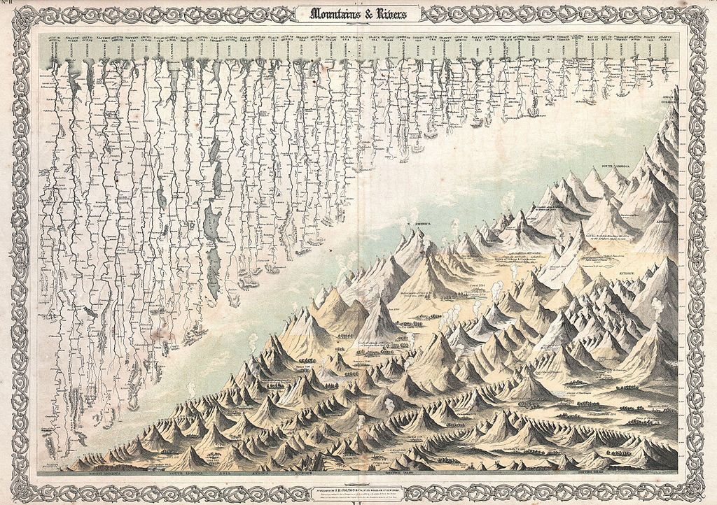
English: Most likely the finest American Mountains and Rivers chart / map of the 19th century. This is the 1855 Colton prototype for the popular 1860-1863 Johnson’s Mountains and Rivers chart. Depicts the relative distances of the world’s great rivers and the relative heights of the world’s great mountains. Includes a multitude of details regarding the heights of important cities, glaciers, volcanoes, and tree lines. Even includes Niagara Falls, the Great Pyramid, St. Peter’s Basilica in Rome and St. Paul’s in London. Also notes curiousitys that would have been relevant at the time, such as The Greatest Altitue of the Growth of Peruvian Bark, The Glacier of Maladetts, the Table Land of Pamar, and the Greatest Altitude attained by Humbolt 19400 ft. Replete with additional geographical errors and misconceptions common to the period. Surrounded by the traditional Colton vine motif border which was dropped from later issues of the atlas. It is extremely rare to find this map such fine condition as this one because it was issued at the front of the Colton Atlas, where most of the heavy damage from moisture, soiling, and general use was sustained. |
||||||||||||||||||||
| Date | 1855 (dated) | ||||||||||||||||||||
| Dimensions | height: 18 in (45.7 cm); width: 26 in (66 cm) | ||||||||||||||||||||
| Accession number |
Geographicus link: MtsRvrs-colton-1855 |
||||||||||||||||||||
| Source/Photographer |
Colton's Atlas Of The World, Illustrating Physical And Political Geography. By George W. Colton., (1855 or 1856 issue).
|
||||||||||||||||||||
| Permission (Reusing this file) |
|
||||||||||||||||||||

File history
Click on a date/time to view the file as it appeared at that time.
| Date/Time | Thumbnail | Dimensions | User | Comment | |
|---|---|---|---|---|---|
| current | 18:44, 17 March 2011 | | 5,000 × 3,524 (5.85 MB) | BotMultichill (talk | contribs) | {{subst:User:Multichill/Geographicus |link=http://www.geographicus.com/P/AntiqueMap/MtsRvrs-colton-1855 |product_name=1855 Colton World Mountains and Rivers Map or Chart |map_title=Mountains & Rivers |description=Most likely the finest American Mountains |
You cannot overwrite this file.
File usage on Commons
The following page uses this file: