File:1855 Colton Pocket Map of the United States - Geographicus - UnitedStatesPk-colton-1855.jpg
Jump to navigation
Jump to search
Size of this preview: 800 × 561 pixels. Other resolutions: 320 × 224 pixels | 640 × 449 pixels | 1,024 × 718 pixels | 1,280 × 898 pixels | 2,560 × 1,796 pixels | 5,000 × 3,507 pixels.
Original file (5,000 × 3,507 pixels, file size: 5.6 MB, MIME type: image/jpeg)
Captions
Captions
Add a one-line explanation of what this file represents
| J. H. Colton: The United States of America.
( |
|||||||||||||||||||||
|---|---|---|---|---|---|---|---|---|---|---|---|---|---|---|---|---|---|---|---|---|---|
| Artist |
|
||||||||||||||||||||
| Title |
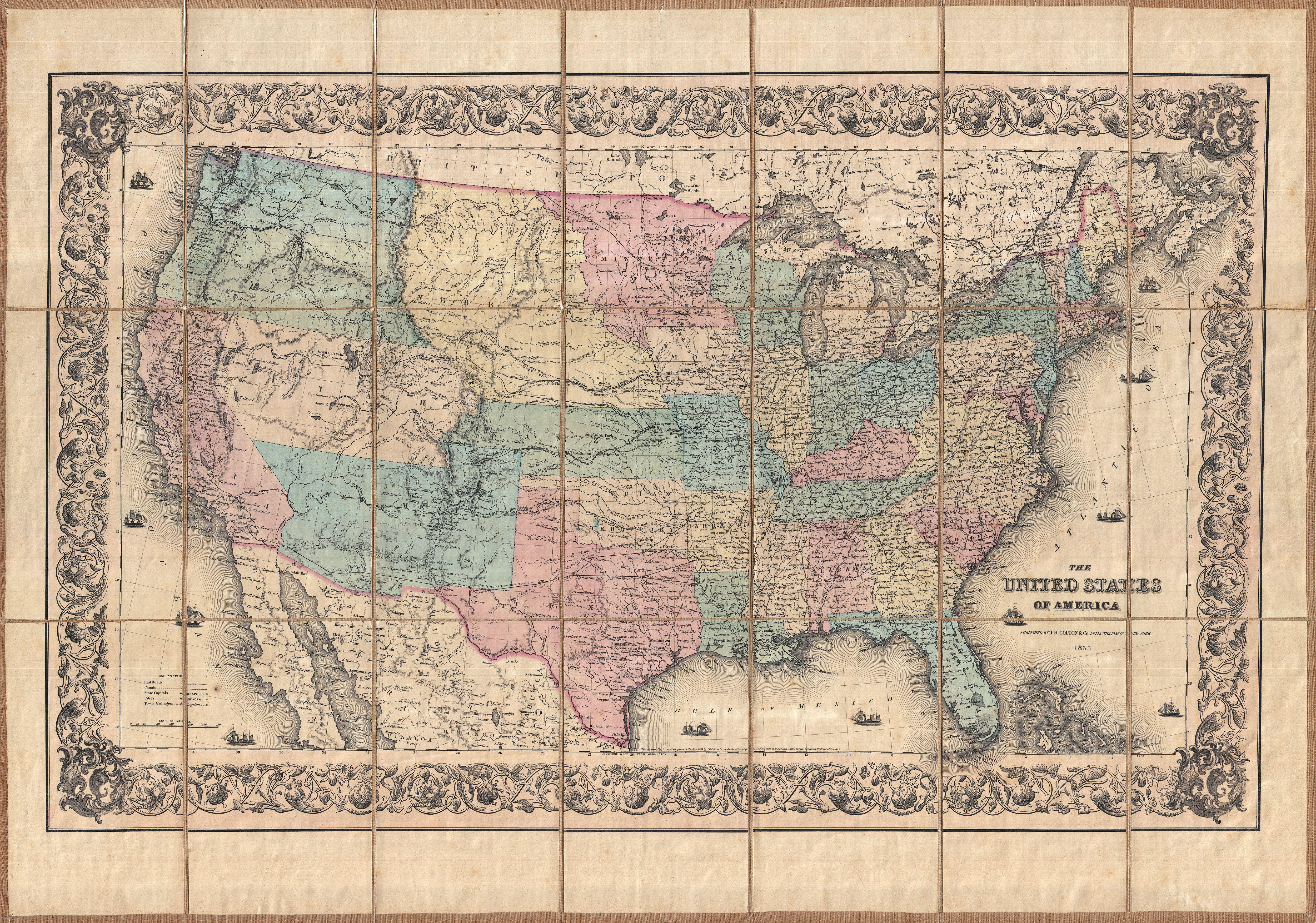
The United States of America. |
||||||||||||||||||||
| Description |
English: This is an extremely scarce separately issued 1855 pocket map of the United States by J.H. Colton. Covers the United States from coast to coast revealing a very early configuration of the Transmississippi. While many modern states had not yet appeared when this map was printed, many other states are exceptionally large. Oregon, Washington Utah New Mexico, Minnesota, and Nebraska, territories all, covered vast regions. A number of extremely important emigrant routes are also noted, including the Oregon Trail, the Santa Fe Trail, and Fremont's Route. Additionally indicates the many routes proposed for the Pacific Railroad including the Stevens route far to the north, two central routes through Utah, and two southern routes through New Mexico. This map is cartographically very similar to Colton's 1855 atlas map of the United States though offers a number of deluxe features including dissection and mounting on linen, an elaborate decorative border, and 11 sailing ships plying the seas. This particular example was originally exported and sold in France by the Longuet firm and was originally owned by G. R. Rupoll or Rupell. |
||||||||||||||||||||
| Date | 1855 (dated) | ||||||||||||||||||||
| Dimensions | height: 21.7 in (55.2 cm); width: 30.7 in (78.1 cm) | ||||||||||||||||||||
| Accession number |
Geographicus link: UnitedStatesPk-colton-1855 |
||||||||||||||||||||
| Source/Photographer |
|
||||||||||||||||||||
| Permission (Reusing this file) |
|
||||||||||||||||||||

File history
Click on a date/time to view the file as it appeared at that time.
| Date/Time | Thumbnail | Dimensions | User | Comment | |
|---|---|---|---|---|---|
| current | 07:40, 24 March 2011 | | 5,000 × 3,507 (5.6 MB) | BotMultichillT (talk | contribs) | {{subst:User:Multichill/Geographicus |link=http://www.geographicus.com/P/AntiqueMap/UnitedStatesPk-colton-1855 |product_name=1855 Colton Pocket Map of the United States |map_title=The United States of America. |description=This is an extremely scarce sepa |
You cannot overwrite this file.
File usage on Commons
The following page uses this file:
File usage on other wikis
The following other wikis use this file:
- Usage on ar.wikipedia.org
- Usage on en.wikipedia.org
- Usage on fr.wikipedia.org