File:1855 Colton Map of Virginia - Geographicus - Virginia-colton-1855.jpg
Jump to navigation
Jump to search
Size of this preview: 729 × 599 pixels. Other resolutions: 292 × 240 pixels | 584 × 480 pixels | 934 × 768 pixels | 1,245 × 1,024 pixels | 2,491 × 2,048 pixels | 4,000 × 3,289 pixels.
Original file (4,000 × 3,289 pixels, file size: 4.08 MB, MIME type: image/jpeg)
Captions
Captions
Add a one-line explanation of what this file represents
| J. H. Colton: Virginia.
( |
|||||||||||||||||||||
|---|---|---|---|---|---|---|---|---|---|---|---|---|---|---|---|---|---|---|---|---|---|
| Artist |
|
||||||||||||||||||||
| Title |
Virginia. |
||||||||||||||||||||
| Description |
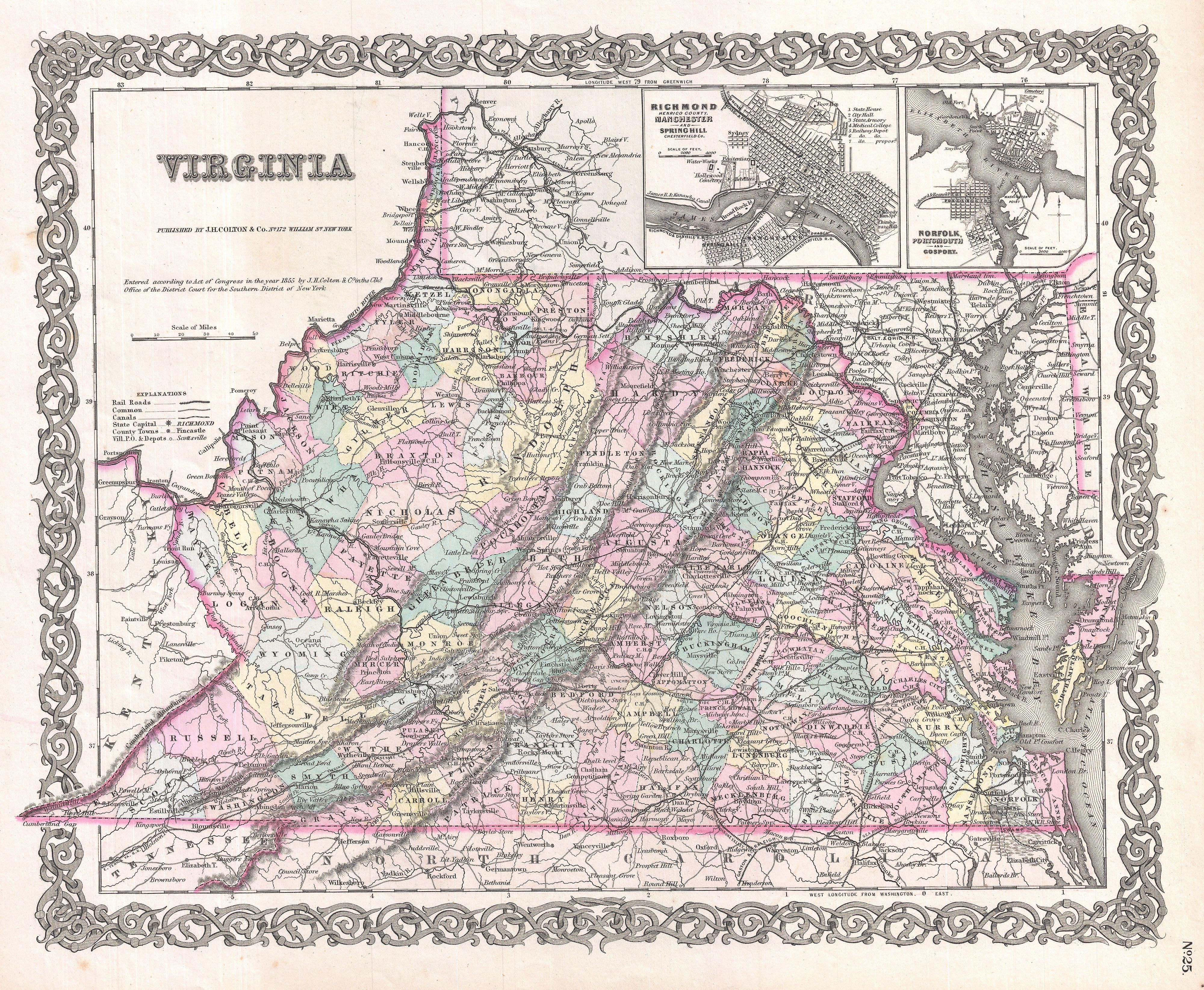
English: A beautiful 1855 first edition example of Colton's map of Virginia. Covers the entire state as well most of adjacent Maryland and parts of North Carolina, Kentucky and Tennessee. Predates split with West Virginia by seven years. Map is hand colored in pink, green, yellow and blue pastels to identify counties. Identifies towns, cities, railroads, roads and some topographical features. Features maps of Richmond (with Manchester and Spring Hill) and Norfolk (with Portsmouth and Gosport). Names the Cumberland Gap, Chesapeake Bay, Alleghany and Shenandoah Mountains, and the Dismal Swamp. Surrounded by Colton's typical spiral motif border. Dated and copyrighted to J. H. Colton, 1855. Published from Colton's 172 William Street Office in New York City. Issued as page no. 25 in volume 1 of the first edition of George Washington Colton's 1855 Atlas of the World. |
||||||||||||||||||||
| Date | 1855 (dated) | ||||||||||||||||||||
| Dimensions | height: 13 in (33 cm); width: 16 in (40.6 cm) | ||||||||||||||||||||
| Accession number |
Geographicus link: Virginia-colton-1855 |
||||||||||||||||||||
| Source/Photographer |
Colton, G. W., Colton's Atlas of the World Illustrating Physical and Political Geography, Vol 1, New York, 1855 (First Edition).
|
||||||||||||||||||||
| Permission (Reusing this file) |
|
||||||||||||||||||||

File history
Click on a date/time to view the file as it appeared at that time.
| Date/Time | Thumbnail | Dimensions | User | Comment | |
|---|---|---|---|---|---|
| current | 10:58, 23 March 2011 | | 4,000 × 3,289 (4.08 MB) | BotMultichillT (talk | contribs) | {{subst:User:Multichill/Geographicus |link=http://www.geographicus.com/P/AntiqueMap/Virginia-colton-1855 |product_name=1855 Colton Map of Virginia |map_title=Virginia. |description=A beautiful 1855 first edition example of Colton's map of Virginia. Cove |
You cannot overwrite this file.
File usage on Commons
The following page uses this file:
File usage on other wikis
The following other wikis use this file:
- Usage on en.wikipedia.org