File:1855 Colton Map of India - Geographicus - India-colton-1855.jpg
Jump to navigation
Jump to search

Size of this preview: 500 × 600 pixels. Other resolutions: 200 × 240 pixels | 400 × 480 pixels | 640 × 768 pixels | 854 × 1,024 pixels | 1,708 × 2,048 pixels | 2,919 × 3,500 pixels.
Original file (2,919 × 3,500 pixels, file size: 2.96 MB, MIME type: image/jpeg)
Captions
Captions
Add a one-line explanation of what this file represents
| J. H. Colton: Hindostan or British India.
( |
|||||||||||||||||||||
|---|---|---|---|---|---|---|---|---|---|---|---|---|---|---|---|---|---|---|---|---|---|
| Artist |
|
||||||||||||||||||||
| Title |
Hindostan or British India. |
||||||||||||||||||||
| Description |
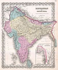
English: A beautiful 1855 first edition example of Colton's map of India. Covers the subcontinent from Tibet to Ceylon (Sri Lanka). Color coded according to region and divided into Bombay, Scinde, Punjab, Nepal, Bhutan, the Bengal Presidency, Madras and Ceylon. An inset map in the lower right quadrant shows British claims in Burma (Pegu) and Southeast Asia. Throughout, Colton identifies various cities, towns, rivers and assortment of additional topographical details. Surrounded by Colton's typical spiral motif border. Dated and copyrighted to J. H. Colton, 1855. Published from Colton's 172 William Street Office in New York City. Issued as page no. 30 in volume 2 of the first edition of George Washington Colton's 1855 Atlas of the World . |
||||||||||||||||||||
| Date | 1855 (dated) | ||||||||||||||||||||
| Dimensions | height: 16.5 in (41.9 cm); width: 13.5 in (34.2 cm) | ||||||||||||||||||||
| Accession number |
Geographicus link: India-colton-1855 |
||||||||||||||||||||
| Source/Photographer |
Colton, G. W., Colton's Atlas of the World Illustrating Physical and Political Geography, Vol 2, New York, 1855 (First Edition).
|
||||||||||||||||||||
| Permission (Reusing this file) |
|
||||||||||||||||||||

File history
Click on a date/time to view the file as it appeared at that time.
| Date/Time | Thumbnail | Dimensions | User | Comment | |
|---|---|---|---|---|---|
| current | 18:41, 23 March 2011 | | 2,919 × 3,500 (2.96 MB) | BotMultichillT (talk | contribs) | {{subst:User:Multichill/Geographicus |link=http://www.geographicus.com/P/AntiqueMap/India-colton-1855 |product_name=1855 Colton Map of India |map_title=Hindostan or British India. |description=A beautiful 1855 first edition example of Colton's map of Indi |
You cannot overwrite this file.
File usage on Commons
The following page uses this file: