File:1852 Bocage Map of North America - Geographicus - AmeriqueSept-bocage-1852.jpg

Original file (2,238 × 3,000 pixels, file size: 2.42 MB, MIME type: image/jpeg)
Captions
Captions
| Carte de L'Amerique Septentrionale dresse ET dessinee sous laDirection de Mr. J. G. Barbie du Bocage. | ||||||
|---|---|---|---|---|---|---|
| Artist | ||||||
| Title |
Carte de L'Amerique Septentrionale dresse ET dessinee sous laDirection de Mr. J. G. Barbie du Bocage. |
|||||
| Description |
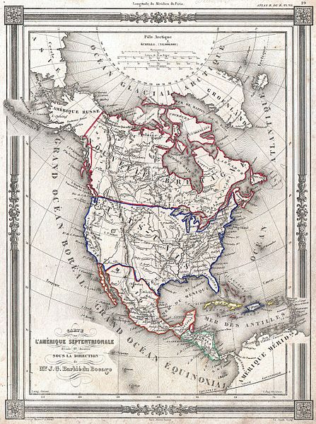
English: An uncommon and extremely attractive 1852 map of North America by J. G. Barbie du Bocage. Depicts all of North America from the Arctic Circle to the northern part of South America. The United States is shown shortly after the acquisition of Texas and Upper California though pre-Gadsden Purchase. Texas border is faint but the state is shown at its fullest extent. Names numerous American Indian tribes including the Osages, Sioux and the Mandan. The Great Salt Lake appears as Lake Tampari. Mt. Jefferson, Mt. Sampson, Mt. Long, Mt. James and Mt. Smith are all labeled. Features a beautiful frame style border. Prepared by J. G. Barbie du Bocage for publication as plate no. 29 in Maison Basset’s 1852 edition of the Atlas Illustre . |
|||||
| Date | 1852 (undated) | |||||
| Dimensions | height: 12.5 in (31.7 cm); width: 9 in (22.8 cm) | |||||
| Accession number |
Geographicus link: AmeriqueSept-bocage-1852 |
|||||
| Source/Photographer |
Maison Basset, Atlas Illustre, (1852 issue).
|
|||||
| Permission (Reusing this file) |
|
|||||
File history
Click on a date/time to view the file as it appeared at that time.
| Date/Time | Thumbnail | Dimensions | User | Comment | |
|---|---|---|---|---|---|
| current | 19:11, 22 March 2011 | | 2,238 × 3,000 (2.42 MB) | BotMultichillT (talk | contribs) | {{subst:User:Multichill/Geographicus |link=http://www.geographicus.com/P/AntiqueMap/AmeriqueSept-bocage-1852 |product_name=1852 Bocage Map of North America |map_title=Carte de L'Amerique Septentrionale dresse ET dessinee sous laDirection de Mr. J. G. Barb |
You cannot overwrite this file.
File usage on Commons
The following page uses this file: