File:1850 Mitchell Map of North Carolina showing Gold Regions - Geographicus - NorthCarolina-mitchell-1850.jpg
Jump to navigation
Jump to search

Size of this preview: 709 × 600 pixels. Other resolutions: 284 × 240 pixels | 568 × 480 pixels | 908 × 768 pixels | 1,211 × 1,024 pixels | 2,422 × 2,048 pixels | 3,500 × 2,960 pixels.
Original file (3,500 × 2,960 pixels, file size: 3.54 MB, MIME type: image/jpeg)
Captions
Captions
Add a one-line explanation of what this file represents
Summary
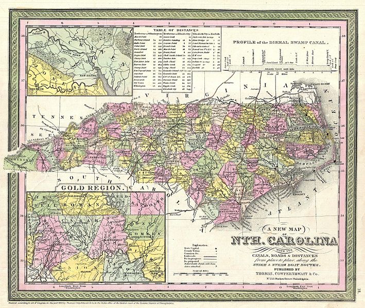
[edit]| Samuel Augustus Mitchell: A New Map of Nth. Carolina with its Canals, Roads & Distances from place to place along the stage & steam boat routes.
( |
||||||||||||||||||||
|---|---|---|---|---|---|---|---|---|---|---|---|---|---|---|---|---|---|---|---|---|
| Artist |
|
|||||||||||||||||||
| Title |
A New Map of Nth. Carolina with its Canals, Roads & Distances from place to place along the stage & steam boat routes. |
|||||||||||||||||||
| Description |
English: A fine example of Samuel Augustus Mitchell’s important 1850 map of North Carolina. This map shows cities, topographical features, railways, ferries and roads with color coding at the county level. In addition to cartographic information this map is full of practical data for the armchair traveler including a profile of the Dismal Swamp Canal (an important trade artery in the region), a Table of Distances, insets of the vicinity of New Berne and the Carolina Gold Region. Of particular interest is Mitchell’s focus on the North Carolina gold region highlighted by an inset in the lower left quadrant. Gold was first discovered in Cabarrus County North Carolina in 1799 by twelve-year-old Conrad Reed. Reed discovered a seventeen-pound gold nugget setting of the nation’s first Gold Rush. Additional gold deposits were soon discovered in neighboring Montgomery, Stanly, Mecklenburg, Rowan and Union counties. The Carolina Gold Rush was a major factor in the settlement and population of the western parts of North Carolina. Cartographically this map is based on the earlier work of Tanner though it has been updated with new information as well as Mitchell’s distinctive decorative border and color scheme. Published as plate no. 18 in the 1850 edition of Mitchell’s New Universal Atlas . Dated and copyrighted: “Entered according to Act of Congress in the year 1850 by Thomas Cowperthwait & Co. in the Clerk’s Office of the District Court of the Eastern District of Pennsylvania. |
|||||||||||||||||||
| Date | 1850 (dated) | |||||||||||||||||||
| Dimensions | height: 12.5 in (31.7 cm); width: 15 in (38.1 cm) | |||||||||||||||||||
| Accession number |
Geographicus link: NorthCarolina-mitchell-1850 |
|||||||||||||||||||
| Source/Photographer |
|
|||||||||||||||||||
| Permission (Reusing this file) |
|
|||||||||||||||||||
| Other versions |
|
|||||||||||||||||||


File history
Click on a date/time to view the file as it appeared at that time.
| Date/Time | Thumbnail | Dimensions | User | Comment | |
|---|---|---|---|---|---|
| current | 04:20, 25 March 2011 | | 3,500 × 2,960 (3.54 MB) | BotMultichillT (talk | contribs) | {{subst:User:Multichill/Geographicus |link=http://www.geographicus.com/P/AntiqueMap/NorthCarolina-mitchell-1850 |product_name=1850 Mitchell Map of North Carolina showing Gold Regions |map_title=A New Map of Nth. Carolina with its Canals, Roads & Distances |
You cannot overwrite this file.
File usage on Commons
The following 4 pages use this file:
Categories:
- Maps by Samuel Augustus Mitchell
- 19th-century maps of North Carolina
- 1850 maps
- Distance tables
- Dismal Swamp Canal
- New Bern, North Carolina
- Maps of Craven County, North Carolina
- Maps of Mecklenburg County, North Carolina
- Maps of Stanly County, North Carolina
- Maps of Cabarrus County, North Carolina
- Gold rushes
- English-language maps
- Maps of counties of North Carolina