File:1848 г. «Карта Малой Чечни и части Владикавказского округа». М. 3 версты в дюйме (I 126000) Ф. 386. Оп. 1. Д. 2863 (2).jpg
Jump to navigation
Jump to search

Size of this preview: 417 × 600 pixels. Other resolutions: 167 × 240 pixels | 334 × 480 pixels | 534 × 768 pixels | 712 × 1,024 pixels | 1,424 × 2,048 pixels | 6,544 × 9,413 pixels.
Original file (6,544 × 9,413 pixels, file size: 72.51 MB, MIME type: image/jpeg)
Captions
Captions
Add a one-line explanation of what this file represents
Summary
[edit]_%D0%A4._386._%D0%9E%D0%BF._1._%D0%94._2863_(2).jpg&action=edit§ion=1)
| Description |
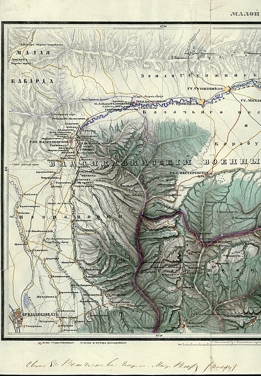
Русский: 1848 г. «Карта Малой Чечни и части Владикавказского округа». М. 3 версты в дюйме (I 126000) Ф. 386. Оп. 1. Д. 2863 (2) |
| Date | |
| Source | File:1848_г._«Карта_Малой_Чечни_и_части_Владикавказского_округа»._М._3_версты_в_дюйме_(I_126000)_Ф._386._Оп._1._Д._2863_(2).tif |
| Author | Unknown author |
Licensing
[edit]_%D0%A4._386._%D0%9E%D0%BF._1._%D0%94._2863_(2).jpg&action=edit§ion=2)
|
This work is in the public domain in its country of origin and other countries and areas where the copyright term is the author's life plus 70 years or fewer. This work is in the public domain in the United States because it was published (or registered with the U.S. Copyright Office) before January 1, 1929. | |
| This file has been identified as being free of known restrictions under copyright law, including all related and neighboring rights. | |
File history
Click on a date/time to view the file as it appeared at that time.
| Date/Time | Thumbnail | Dimensions | User | Comment | |
|---|---|---|---|---|---|
| current | 21:41, 15 September 2020 | | 6,544 × 9,413 (72.51 MB) | Takhirgeran Umar (talk | contribs) | Uploaded a work by неизвестен from https://commons.wikimedia.org/wiki/File:1848_%D0%B3._%C2%AB%D0%9A%D0%B0%D1%80%D1%82%D0%B0_%D0%9C%D0%B0%D0%BB%D0%BE%D0%B9_%D0%A7%D0%B5%D1%87%D0%BD%D0%B8_%D0%B8_%D1%87%D0%B0%D1%81%D1%82%D0%B8_%D0%92%D0%BB%D0%B0%D0%B4%D0%B8%D0%BA%D0%B0%D0%B2%D0%BA%D0%B0%D0%B7%D1%81%D0%BA%D0%BE%D0%B3%D0%BE_%D0%BE%D0%BA%D1%80%D1%83%D0%B3%D0%B0%C2%BB._%D0%9C._3_%D0%B2%D0%B5%D1%80%D1%81%D1%82%D1%8B_%D0%B2_%D0%B4%D1%8E%D0%B9%D0%BC%D0%B5_(I_126000)_%D0%A4._386._%D0%9E%D0%BF._1._%D0%... |
You cannot overwrite this file.
File usage on Commons
The following page uses this file:
_Ф._386._Оп._1._Д._2863_(2).jpg&oldid=780756487)