File:1847 U.S. Coast Survey Map of Holmes' Hole (Vineyard Haven), Martha's Vineyard, Massachusetts - Geographicus - HolmesHole-uscs-1847.jpg
Jump to navigation
Jump to search

Size of this preview: 800 × 589 pixels. Other resolutions: 320 × 236 pixels | 640 × 471 pixels | 1,024 × 754 pixels | 1,280 × 942 pixels | 2,560 × 1,884 pixels | 3,500 × 2,576 pixels.
Original file (3,500 × 2,576 pixels, file size: 2.35 MB, MIME type: image/jpeg)
Captions
Captions
Add a one-line explanation of what this file represents
| Harbor of Refuge No. The Harbor of Holmes' Hole. | ||||||
|---|---|---|---|---|---|---|
| Artist | ||||||
| Title |
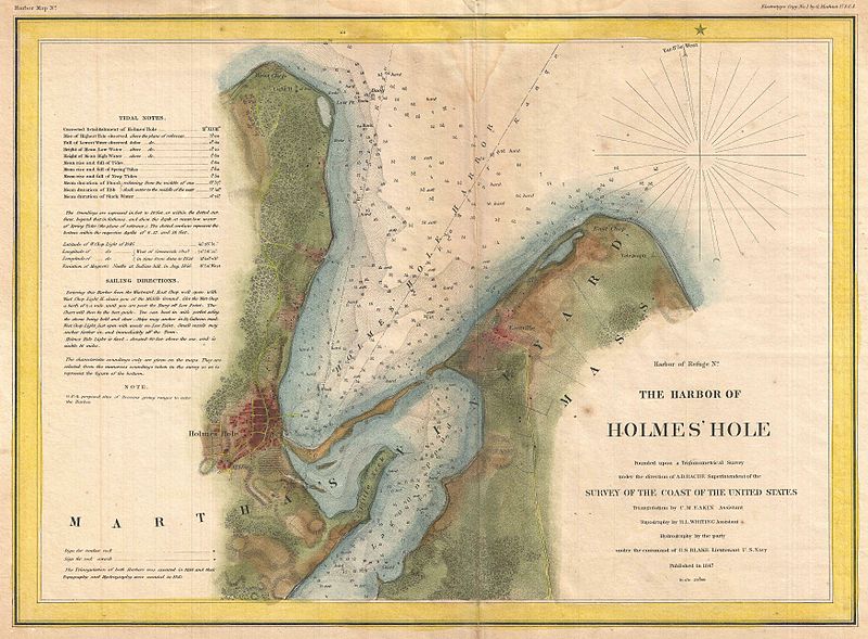
Harbor of Refuge No. The Harbor of Holmes' Hole. |
|||||
| Description |
English: This is a rare example of the 1847 U.S. Coast Survey nautical chart or map of Holmes’ Hole (Vineyard Haven), Martha’s Vineyard, Massachusetts. Focusing on the town of Holmes’ Hole, today’s Vineyard Haven, this map covers from West Chop to East Chop and as far south as Little Neck and Lagoon Pond. Presents a rare mid-19th century view of one of Martha’s Vineyard’s three main population centers. This map offers exceptional inland detail noting individual streets, farms and buildings in Holmes’ Hole and Eastville. Countless depth sounding throughout. The upper left quadrant features notes on tides and detailed sailing instructions. The triangulation for this chart was completed by C. M. Eakin. The stunning topographical detail is the work of H. I. Witing. The hydrography was completed by a party under the command of G. S. Blake. The entire chart was produced under the supervision of A. D. Bache, of the most prolific and influential Superintendents of the U.S. Coast Survey. The map was not originally colored. Coloring maps is a common practice today to make the map more visually interesting but it is not authentic or attributed to the original map maker. An example of the original appearance of this map can be found here http://www.raremaps.com/gallery/detail/25393/The_Harbor_of_Holmes_Hole_1847/United%20States%20Coast%20Survey.html |
|||||
| Date | 1847 (dated) | |||||
| Dimensions | height: 10.5 in (26.6 cm); width: 14.5 in (36.8 cm) | |||||
| Accession number |
Geographicus link: HolmesHole-uscs-1847 |
|||||
| Source/Photographer |
Report of the Superintendant of the United States Coast Survey, (Washington) 1847.
|
|||||
| Permission (Reusing this file) |
|
|||||
File history
Click on a date/time to view the file as it appeared at that time.
| Date/Time | Thumbnail | Dimensions | User | Comment | |
|---|---|---|---|---|---|
| current | 05:21, 25 March 2011 | | 3,500 × 2,576 (2.35 MB) | BotMultichillT (talk | contribs) | {{subst:User:Multichill/Geographicus |link=http://www.geographicus.com/P/AntiqueMap/HolmesHole-uscs-1847 |product_name=1847 U.S. Coast Survey Map of Holmes' Hole (Vineyard Haven), Martha's Vineyard, Massachusetts |map_title=Harbor of Refuge No. The Harbor |
You cannot overwrite this file.
File usage on Commons
The following page uses this file:
,_Martha%27s_Vineyard,_Massachusetts_-_Geographicus_-_HolmesHole-uscs-1847.jpg)
,_Martha%27s_Vineyard,_Massachusetts_-_Geographicus_-_HolmesHole-uscs-1847.jpg&oldid=921276283)