File:1846 Colton Map of New York City and Vicinity (33 Miles Around) - Geographicus - NewYork33MilesAround-colton-1855.jpg
Jump to navigation
Jump to search

Size of this preview: 565 × 599 pixels. Other resolutions: 226 × 240 pixels | 453 × 480 pixels | 724 × 768 pixels | 966 × 1,024 pixels | 1,932 × 2,048 pixels | 5,000 × 5,301 pixels.
Original file (5,000 × 5,301 pixels, file size: 8.93 MB, MIME type: image/jpeg)
Captions
Captions
Add a one-line explanation of what this file represents
| J. H. Colton: Map Of The Country Thirty Three Miles Around The City Of New York.
( |
|||||||||||||||||||||
|---|---|---|---|---|---|---|---|---|---|---|---|---|---|---|---|---|---|---|---|---|---|
| Artist |
|
||||||||||||||||||||
| Title |
Map Of The Country Thirty Three Miles Around The City Of New York. |
||||||||||||||||||||
| Description |
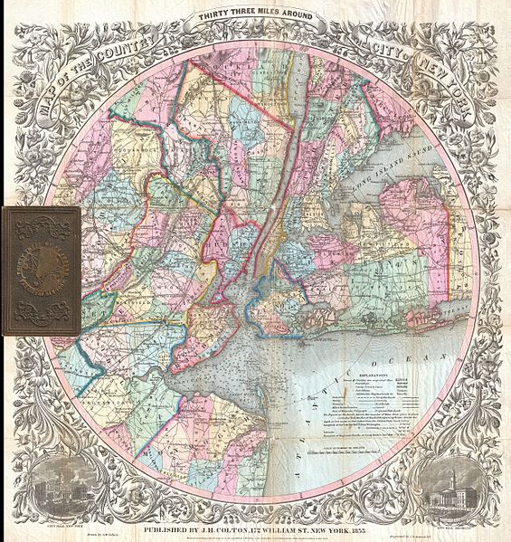
English: This is the extremely rare 1855 edition of one of the most beautiful pocket maps of New York made in the 19th century: Colton’s Thirty Three Miles Around the City of New York . Covers New York City and vicinity as far south as Ocean County, New Jersey, as far east as Suffolk County, as far north as Rockland County, and as far west as Somerset County. Reveals the area in considerable detail with special attention to settlements, tolls, roads, and railroads. New York Bay and Harbor offers numerous depth soundings taken from the 1850 U.S. Coast Survey chart of the region. Surrounded by a splendid decorative border with engraved views depicting “City Hall, New York” and “City Hall, Brooklyn.” This map was drawn and engraved by J. M Atwood based upon J. H. Eddy’s 1811 map of the same name. Colton’s success with this attractive map was such that it was issued in various editions for over 50 years. Haskell notes eight different editions between 1846 and 1873 and Rumsey has a variant dated 1891. Comes with original brown linen binder with a miniature map of the city in gilt stamped on the cover. Dated 1855 to right of the imprint, below map proper. Below this, at the base of the map, the copyright reads: “Entered according to the Act of Congress in the Year of 1846 by J. H. Colton & Co. in the Clerk’s Office of the District Court of the Southern District of New York.” Published by the Colton firm, prior to their 1859 bankruptcy, from their 172 William Str. Office in New York City. |
||||||||||||||||||||
| Date | 1855 (dated) | ||||||||||||||||||||
| Dimensions | height: 24 in (60.9 cm); width: 22.5 in (57.1 cm) | ||||||||||||||||||||
| Accession number |
Geographicus link: NewYork33MilesAround-colton-1855 |
||||||||||||||||||||
| Source/Photographer |
|
||||||||||||||||||||
| Permission (Reusing this file) |
|
||||||||||||||||||||

File history
Click on a date/time to view the file as it appeared at that time.
| Date/Time | Thumbnail | Dimensions | User | Comment | |
|---|---|---|---|---|---|
| current | 15:01, 23 March 2011 | | 5,000 × 5,301 (8.93 MB) | BotMultichillT (talk | contribs) | {{subst:User:Multichill/Geographicus |link=http://www.geographicus.com/P/AntiqueMap/NewYork33MilesAround-colton-1855 |product_name=1846 Colton Map of New York City and Vicinity (33 Miles Around) |map_title=Map Of The Country Thirty Three Miles Around The |
You cannot overwrite this file.
File usage on Commons
The following page uses this file:
_-_Geographicus_-_NewYork33MilesAround-colton-1855.jpg)
_-_Geographicus_-_NewYork33MilesAround-colton-1855.jpg&oldid=864629658)