File:1839 Burr Wall Map of the United States (only example of Jedediah Smith's map) - Geographicus - UnitedStates-burr-1839.jpg
Jump to navigation
Jump to search
Size of this preview: 797 × 600 pixels. Other resolutions: 319 × 240 pixels | 638 × 480 pixels | 1,021 × 768 pixels | 1,280 × 963 pixels | 2,560 × 1,927 pixels | 6,000 × 4,516 pixels.
Original file (6,000 × 4,516 pixels, file size: 6.46 MB, MIME type: image/jpeg)
Captions
Captions
Add a one-line explanation of what this file represents
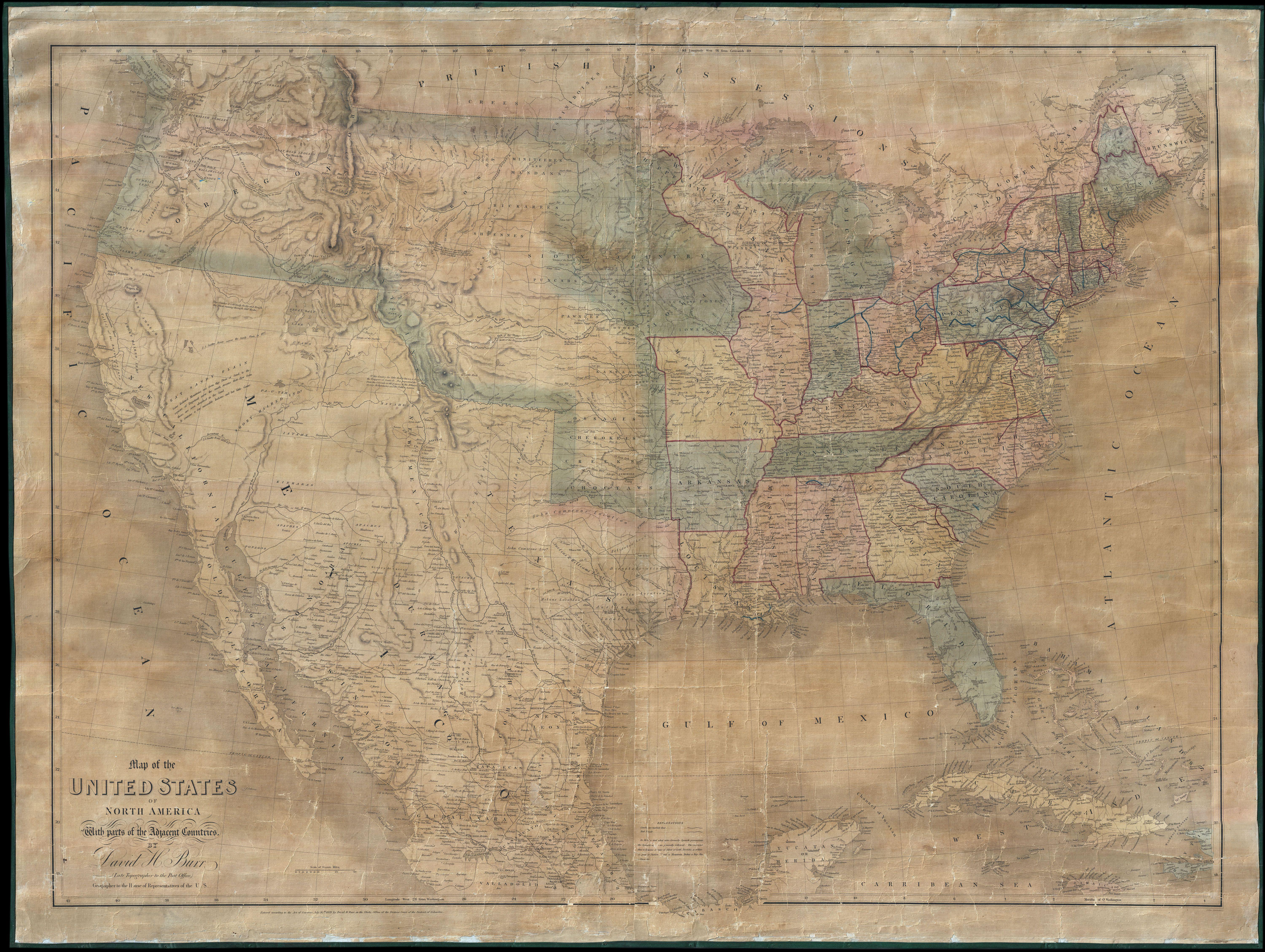
| Map of the United States Of North America With parts of the Adjacent Countries. | ||||||
|---|---|---|---|---|---|---|
| Artist | ||||||
| Title |
Map of the United States Of North America With parts of the Adjacent Countries. |
|||||
| Description |
English: This is David H. Burr's all but unobtainable 1839 wall map of the United States. Burr's map is an accomplishment of staggering significance and is considered the culmination of one of the most dramatic and romantic periods in the mapping of the American West. It is further one of the most significant maps in the opening of the American West to the Gold Rush that, in just a few years, would transform the nation. Between the expedition of Louis and Clark in 1804 - 1806 and the work of Fremont in the 1840s, the exploration of the Transmississippi experienced a kind of dark age. Nevertheless, while no official teams were pushing cartography westward, trappers and fur traders were slowly penetrating the region. Most of these figures were illiterate and did little to extend cartographic knowledge. The exception was Jedediah Smith, a trapper whose wanderings in the west and subsequent cartographic innovations the historian C. I. Wheat considers a tour-de-force unprecedented and never equaled in the annals of Western exploration. Smith spent roughly 9 years, between 1821 and 1830, exploring the Great Basin, the Sierra Nevada, the Rocky Mountains and the valleys of California, but sadly perished before his important work could be published. Smith's now lost map was taken by his partner and friend, Missouri Congressman William H. Ashely, and eventually made its way into the hands of David H. Burr, who was then composing his own important map of the United States - offered here. Smith's work must have seemed a revelation to Burr who struggled to reconcile conflicts between the mappings of Humboldt, Pike, Miera, and of course, Lewis and Clark. Burr, realizing the importance of Smith's work, incorporated it throughout his map, thus redefining the cartographic representation of the region. Shortly after Burr published this seminal map, Smith's original manuscript was lost, making Burr's map the sole printed representation of Smith's work. Curiously and somewhat inexplicably, this map never attained significant popularity in its day, leading to a very small publication run and, today, extreme rarity. Our survey of Burr's map must begin in the east. Burr, having just competed individual state plates for the 1835 issue of his New Universal Atlas had a relatively easy task of assembling the individual mappings into a cohesive whole. However, several elements do bear note. Burr identifies the nation's fledgling rail network, which is strongest in the northeast, with bold blue and red lines. In the state of Maine both the disputed British boundary, roughly along the 47th parallel, and the far northern boundary claimed by the state of Maine are noted. Heading west the territory becomes less settled and the character of the map changes. Particularly in Wisconsin and what would soon become Iowa, towns are few and far between, instead the map shifts its focus to notating American Indian Nations as well as the locations of forts, mills, lakes, portages, rapids, and waterfalls. Several land exchanges and treaties with various American Indian groups including the Sioux, the Sacs and Foxes, and the Chippewa are also identified. When Burr drew this map, Missouri was the westernmost state and the jumping point for most significant journeys westward. Beyond the borders of Missouri the territory is dominated by the American Indian Nations recently relocated to western lands by the Indian Removal Act of 1830. These includes the Osages, Cherokee, Creek and Choctaw. Further north the territories of the Otoes, Kansas, and Shawnees are noted. The map also identifies important landmarks on the route westward including the fur trapping forts on the Arkansas River (Gant and Bent), various springs, Pikes Peak, James Peak, and the Spanish Peaks. Where known military routes through the region are sketched in, including Major Long's Route and more importantly the Route of the Dragoons under Col. |
|||||
| Date | 1839 (dated) | |||||
| Dimensions | height: 38 in (96.5 cm); width: 51 in (129.5 cm) | |||||
| Accession number |
Geographicus link: UnitedStates-burr-1839 |
|||||
| Source/Photographer |
|
|||||
| Permission (Reusing this file) |
|
|||||
File history
Click on a date/time to view the file as it appeared at that time.
| Date/Time | Thumbnail | Dimensions | User | Comment | |
|---|---|---|---|---|---|
| current | 03:02, 24 March 2011 | | 6,000 × 4,516 (6.46 MB) | BotMultichillT (talk | contribs) | {{subst:User:Multichill/Geographicus |link=http://www.geographicus.com/P/AntiqueMap/UnitedStates-burr-1839 |product_name=1839 Burr Wall Map of the United States (only example of Jedediah Smith's map) |map_title=Map of the United States Of North America Wi |
You cannot overwrite this file.
File usage on Commons
The following page uses this file:
_-_Geographicus_-_UnitedStates-burr-1839.jpg)
_-_Geographicus_-_UnitedStates-burr-1839.jpg&oldid=744965802)