File:1836 Limburg a. d. Lenne.jpg
Jump to navigation
Jump to search

Size of this preview: 800 × 535 pixels. Other resolutions: 320 × 214 pixels | 640 × 428 pixels | 1,024 × 685 pixels | 1,280 × 856 pixels | 2,545 × 1,702 pixels.
Original file (2,545 × 1,702 pixels, file size: 2.55 MB, MIME type: image/jpeg)
Captions
Captions
Add a one-line explanation of what this file represents
Summary
[edit]
| Description |
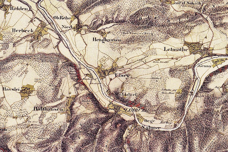
Deutsch: Kartenausschnitt aus dem Jahre 1836. Limburg a. d. Lenne mit (v.o.) Ober-/Nieder-Reh, Henkhausen, Elsey, Sundernhof (Drahtrolle), Mühlendorf, Oege, Neu-Oege (Eisen-/Blechhammer) und Nahmer. Limburg wurde 1879 in Hohenlimburg umbenannt. 1885 gab es in Hohenlimburg 480 Wohnhäuser mit 1135 Haushaltungen und 5836 Einwohner. In dem noch eigenständigen Elsey (Eingemeindung 1902) gab es 204 Wohnhäuser mit 481 Haushaltungen und 2466 Einwohner. Westlich angrenzend liegen Holthausen, Haßley, Herbeck und Halden, östlich Letmathe mit Genna. |
| Date | |
| Source | tim-online.nrw.de – Uraufnahme 1836-1850 |
| Author | NRW-Kartendienst, LAND NRW (2018) |
Licensing
[edit]
|
This work is in the public domain in its country of origin and other countries and areas where the copyright term is the author's life plus 100 years or fewer. This work is in the public domain in the United States because it was published (or registered with the U.S. Copyright Office) before January 1, 1929. | |
| This file has been identified as being free of known restrictions under copyright law, including all related and neighboring rights. | |
File history
Click on a date/time to view the file as it appeared at that time.
| Date/Time | Thumbnail | Dimensions | User | Comment | |
|---|---|---|---|---|---|
| current | 12:04, 21 November 2018 | | 2,545 × 1,702 (2.55 MB) | Bärwinkel,Klaus (talk | contribs) | Vergrößerte Version der Datei. Selbst bearbeitet am 21.11.2018 ~~~~ |
| 16:32, 19 November 2018 |  | 1,911 × 1,732 (2.06 MB) | Bärwinkel,Klaus (talk | contribs) | Etwas veränderte Version der Datei. Selbst bearbeitet am 19.11.2018 ~~~~ | |
| 16:01, 19 November 2018 |  | 1,911 × 1,732 (2.05 MB) | Bärwinkel,Klaus (talk | contribs) | {{Information |description ={{de|1=Kartenausschnitt aus dem Jahre 1836. Limburg a. d. Lenne mit (v.o.l.) Ober-/Nieder-Reh, Henkhausen, Elsey, Mühlendorf, Oege, Neu-Oege und Nahmer.}} |date =1836 |source =tim-online.nrw.de – Uraufnahme 1836-1850 |author =NRW-Kartendienst, LAND NRW (2018) }} Category:History of Hohenlimburg |
You cannot overwrite this file.
File usage on Commons
There are no pages that use this file.