File:1826 Finley Comparative Map of the Principle Mountains of the World - Geographicus - Mountains-finley-1826.jpg
Jump to navigation
Jump to search
Size of this preview: 455 × 600 pixels. Other resolutions: 182 × 240 pixels | 364 × 480 pixels | 583 × 768 pixels | 777 × 1,024 pixels | 2,276 × 3,000 pixels.
Original file (2,276 × 3,000 pixels, file size: 2.13 MB, MIME type: image/jpeg)
Captions
Captions
Add a one-line explanation of what this file represents
| Anthony Finley: Table of the Comparative Heights of the Principal Mountains & c. in the World.
( |
||||||||||||||
|---|---|---|---|---|---|---|---|---|---|---|---|---|---|---|
| Artist |
|
|||||||||||||
| Title |
Table of the Comparative Heights of the Principal Mountains & c. in the World. |
|||||||||||||
| Description |
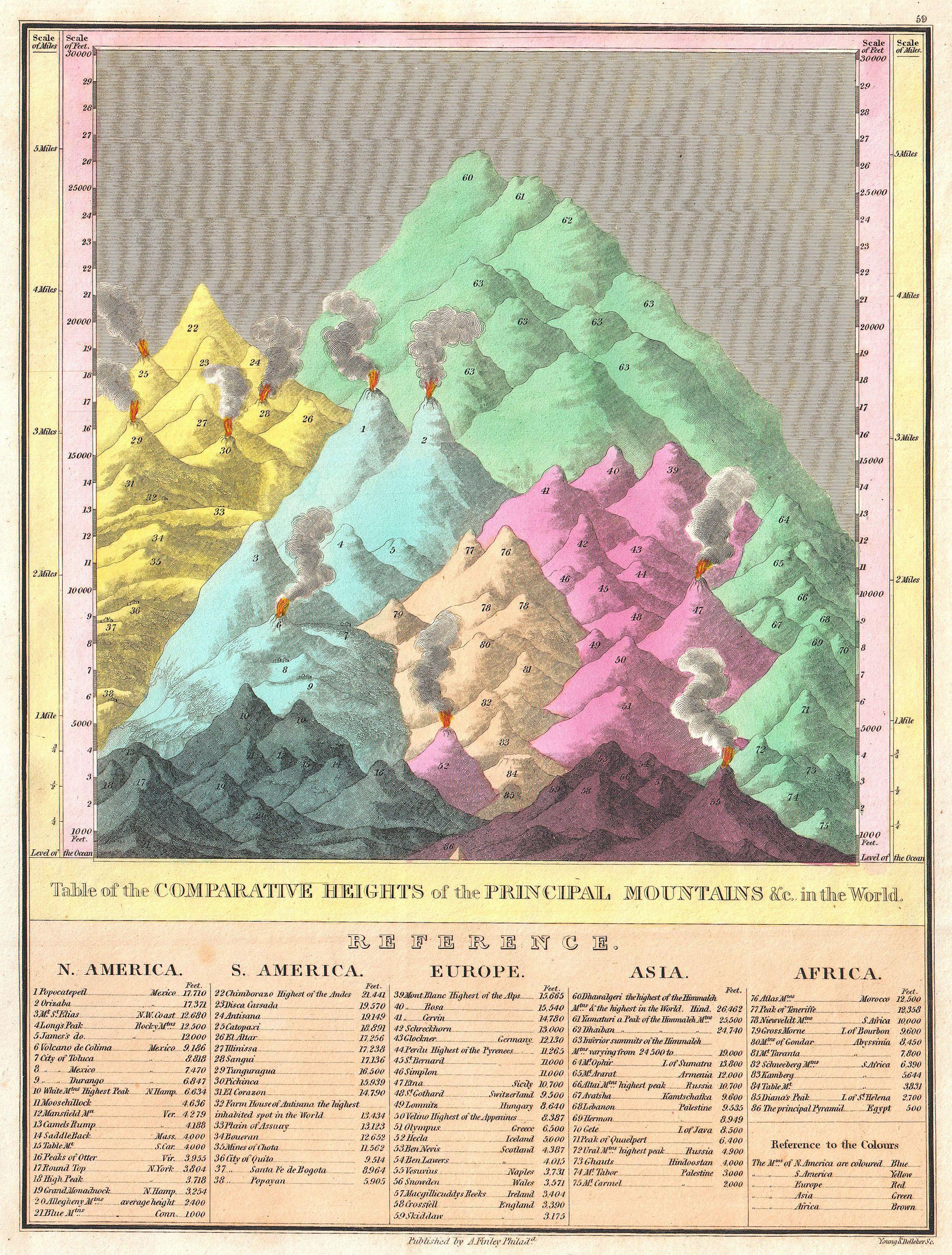
English: This is Finley’s attractive c. 1826 map of the comparative heights of the principal mountains of the world. Details the world’s great mountains in relative proximity to one another and divided by continent. Each mountain is numbered and refers to a reference list below the chart proper, naming each mountain and its elevation. Also notes important cities, mines, volcanoes and geographical locations, including the Great Pyramid. The highest mountain in North America is Mexico’s Popocatepetl, in South America it is Chimborazo, in Europe Mont Blanc, in Asia Dhaulagiri, and in Africa the Atlas Mountains of Morocco. Predates the discovery of Everest, Kilimanjaro, Mt. Kenya, and Mt. McKinley (Denali). Prepared by Young and Delleker as plate no. 59 in the 1826 edition of Finley’s New General Atlas . |
|||||||||||||
| Date | 1826 (undated) | |||||||||||||
| Dimensions | height: 11.7 in (29.8 cm); width: 9 in (22.8 cm) | |||||||||||||
| Accession number |
Geographicus link: Mountains-finley-1826 |
|||||||||||||
| Source/Photographer |
A New General Atlas Comprising a Complete Set of Maps, representing the Grand Divisions Of The Globe, (1826 editon).
|
|||||||||||||
| Permission (Reusing this file) |
|
|||||||||||||
File history
Click on a date/time to view the file as it appeared at that time.
| Date/Time | Thumbnail | Dimensions | User | Comment | |
|---|---|---|---|---|---|
| current | 19:36, 17 March 2011 | | 2,276 × 3,000 (2.13 MB) | BotMultichill (talk | contribs) | {{subst:User:Multichill/Geographicus |link=http://www.geographicus.com/P/AntiqueMap/Mountains-finley-1826 |product_name=1826 Finley Comparative Map of the Principle Mountains of the World |map_title=Table of the Comparative Heights of the Principal Mounta |
You cannot overwrite this file.
File usage on Commons
The following page uses this file: