File:1819-TraitéTurin-Arande.jpg
Jump to navigation
Jump to search
No higher resolution available.
1819-TraitéTurin-Arande.jpg (365 × 367 pixels, file size: 38 KB, MIME type: image/jpeg)
Captions
Captions
Add a one-line explanation of what this file represents
Summary
[edit]
| Description |
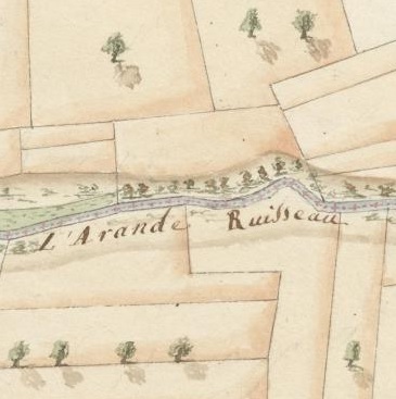
Français : Détail montrant le ruisseau « l'Arande » faisant frontière entre l'ancienne commune de Compesières dans le canton de Genève et Saint-Julien en Savoie. Détail d'une carte topographique des frontières du duché de Savoie et du canton de Genève dressée en exécution du traité de Turin du 16 mars 1816 et du procès-verbal de plantation des bornes du 20 octobre 1819. Voir en ligne. |
| Date | |
| Source | Archives d'Etat de Genève, AEG Plans annexes des traités 7 |
| Author | Magny et Prévot-Pictet |
Licensing
[edit]
|
This work is in the public domain in its country of origin and other countries and areas where the copyright term is the author's life plus 100 years or fewer. This work is in the public domain in the United States because it was published (or registered with the U.S. Copyright Office) before January 1, 1929. | |
| This file has been identified as being free of known restrictions under copyright law, including all related and neighboring rights. | |
File history
Click on a date/time to view the file as it appeared at that time.
| Date/Time | Thumbnail | Dimensions | User | Comment | |
|---|---|---|---|---|---|
| current | 15:16, 7 January 2019 | | 365 × 367 (38 KB) | MHM55 (talk | contribs) | User created page with UploadWizard |
You cannot overwrite this file.
File usage on Commons
There are no pages that use this file.
File usage on other wikis
The following other wikis use this file:
- Usage on fr.wikipedia.org