File:1818 Pinkerton Map of the Southern Hemisphere ( South Pole, Antarctic ) - Geographicus - SouthernHemisphere-pinkerton-1818.jpg
Jump to navigation
Jump to search

Size of this preview: 800 × 553 pixels. Other resolutions: 320 × 221 pixels | 640 × 443 pixels | 1,024 × 708 pixels | 1,280 × 885 pixels | 2,560 × 1,770 pixels | 5,000 × 3,458 pixels.
Original file (5,000 × 3,458 pixels, file size: 3.09 MB, MIME type: image/jpeg)
Captions
Captions
Add a one-line explanation of what this file represents
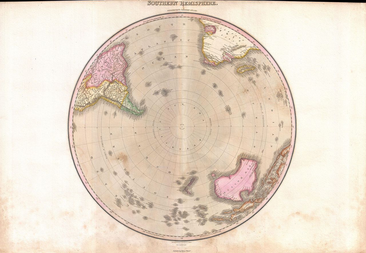
| John Pinkerton: Southern Hemisphere.
( |
|||||||||||||||||||||
|---|---|---|---|---|---|---|---|---|---|---|---|---|---|---|---|---|---|---|---|---|---|
| Artist |
|
||||||||||||||||||||
| Title |
Southern Hemisphere. |
||||||||||||||||||||
| Description |
English: A rare and important 1818 map of the Southern Hemisphere by John Pinkerton. On a Polar projection, this map depicts Australia, Polynesia, and the parts of South America and Africa. This map was issued after the search for Terra Australis , or the Great Southern Continent, had been abandoned, but prior to the discovery of Antarctica - consequently the South Pole is depicted as a vast ocean called Icy Sea. In the more populated lands to the north, this map offers fairly accurate shorelines throughout. In Africa, the interior remains unexplored except for the Congo, the Cape Colony and the gold mining regions of Monomotapa. Similarly, the coasts of Australia are accurate but the interior is vague and unknown. Drawn by L. Herbert and engraved by Samuel Neele under the direction of John Pinkerton. The map comes from the scarce American edition of Pinkerton’s Modern Atlas, published by Thomas Dobson & Co. of Philadelphia in 1818. |
||||||||||||||||||||
| Date | 1818 (undated) | ||||||||||||||||||||
| Dimensions | height: 22 in (55.8 cm); width: 20 in (50.8 cm) | ||||||||||||||||||||
| Accession number |
Geographicus link: SouthernHemisphere-pinkerton-1818 |
||||||||||||||||||||
| Source/Photographer |
Pinkerton, J., A Modern Atlas, from the Lates and Best Authorities, Exhibiting the Various Divisions of the World with its chief Empires, Kingdoms, and States; in Sixty Maps, carefully reduced from the Larges and Most Authentic Sources. 1818, Philadelphia, Thomas Dobson Edition.
|
||||||||||||||||||||
| Permission (Reusing this file) |
|
||||||||||||||||||||

File history
Click on a date/time to view the file as it appeared at that time.
| Date/Time | Thumbnail | Dimensions | User | Comment | |
|---|---|---|---|---|---|
| current | 05:44, 23 March 2011 | | 5,000 × 3,458 (3.09 MB) | BotMultichillT (talk | contribs) | {{subst:User:Multichill/Geographicus |link=http://www.geographicus.com/P/AntiqueMap/SouthernHemisphere-pinkerton-1818 |product_name=1818 Pinkerton Map of the Southern Hemisphere ( South Pole, Antarctic ) |map_title=Southern Hemisphere. |description=A rare |
You cannot overwrite this file.
File usage on Commons
The following page uses this file:
_-_Geographicus_-_SouthernHemisphere-pinkerton-1818.jpg)
_-_Geographicus_-_SouthernHemisphere-pinkerton-1818.jpg&oldid=753507496)