File:1818 Pinkerton Map of Holland or the Netherlands - Geographicus - Holland-pinkerton-1818.jpg
Jump to navigation
Jump to search
Size of this preview: 673 × 600 pixels. Other resolutions: 269 × 240 pixels | 539 × 480 pixels | 862 × 768 pixels | 1,149 × 1,024 pixels | 2,298 × 2,048 pixels | 5,000 × 4,457 pixels.
Original file (5,000 × 4,457 pixels, file size: 6.09 MB, MIME type: image/jpeg)
Captions
Captions
Add a one-line explanation of what this file represents
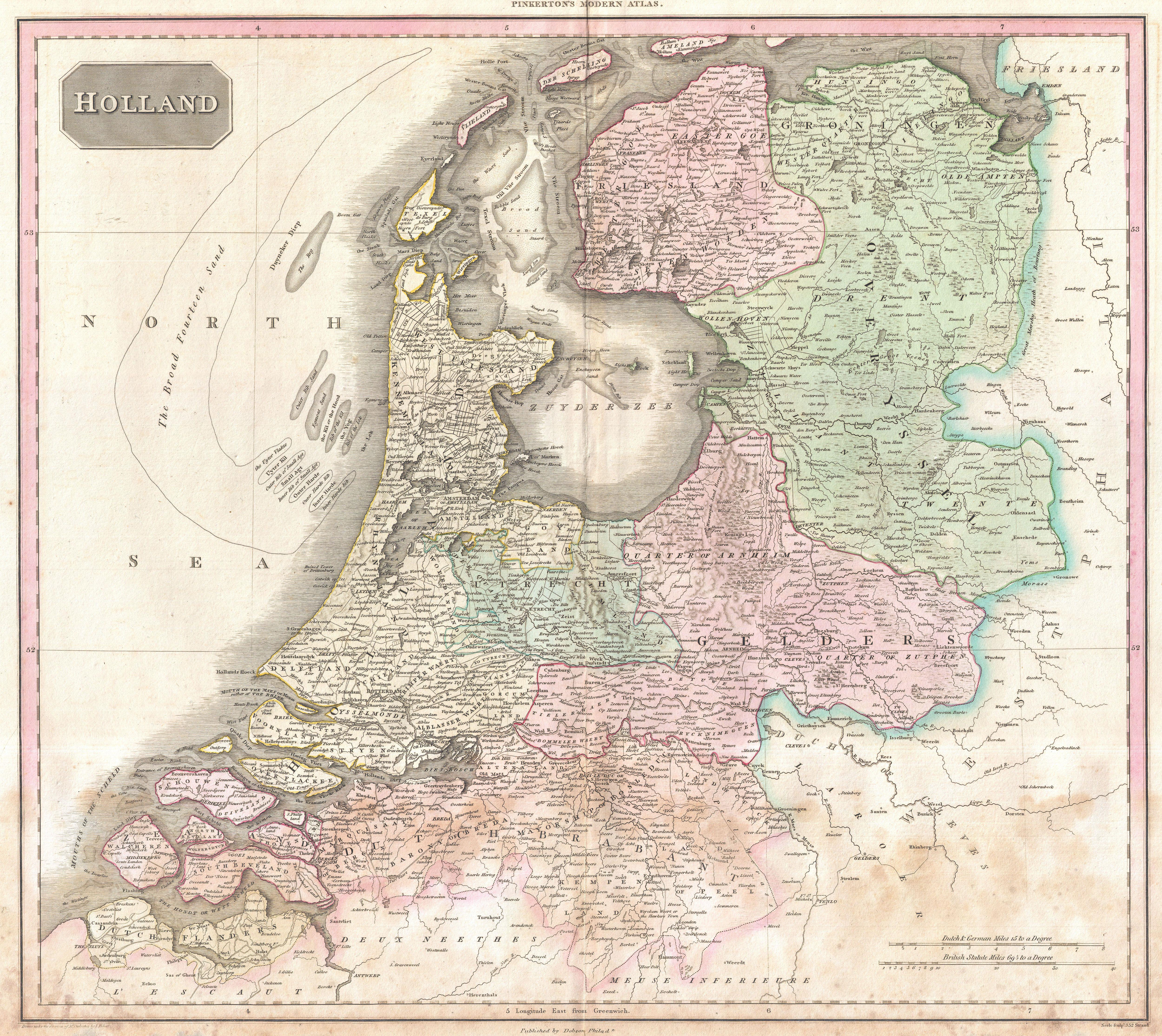
| John Pinkerton: Holland.
( |
|||||||||||||||||||||
|---|---|---|---|---|---|---|---|---|---|---|---|---|---|---|---|---|---|---|---|---|---|
| Artist |
|
||||||||||||||||||||
| Title |
Holland. |
||||||||||||||||||||
| Description |
English: Pinkerton's extraordinary 1818 map of Holland. Covers what is essentially today's Netherlands between the Belgium and Germany. Offers excellent undersea detail regarding various shoals and other dangers, including the Broad Fourteen Sand. Also shows the elaborate system of canals and irrigation networks throughout the region. Offers considerable detail with political divisions and color coding at the regional level. Identifies cities, towns, castles, important battle sites, castles, swamps, mountains and river ways. Title plate in the upper left quadrant. Two mile scales, in Dutch and German Miles and British Statute Miles, also appear in the lower right quadrant. Drawn by L. Herbert and engraved by Samuel Neele under the direction of John Pinkerton. This map comes from the scarce American edition of Pinkerton’s Modern Atlas, published by Thomas Dobson & Co. of Philadelphia in 1818. |
||||||||||||||||||||
| Date | 1818 (undated) | ||||||||||||||||||||
| Dimensions | height: 20.5 in (52 cm); width: 28 in (71.1 cm) | ||||||||||||||||||||
| Accession number |
Geographicus link: Holland-pinkerton-1818 |
||||||||||||||||||||
| Source/Photographer |
Pinkerton, J., A Modern Atlas, from the Lates and Best Authorities, Exhibiting the Various Divisions of the World with its chief Empires, Kingdoms, and States; in Sixty Maps, carefully reduced from the Larges and Most Authentic Sources. 1818, Philadelphia, Thomas Dobson Edition.
|
||||||||||||||||||||
| Permission (Reusing this file) |
|
||||||||||||||||||||

File history
Click on a date/time to view the file as it appeared at that time.
| Date/Time | Thumbnail | Dimensions | User | Comment | |
|---|---|---|---|---|---|
| current | 08:00, 23 March 2011 | | 5,000 × 4,457 (6.09 MB) | BotMultichillT (talk | contribs) | {{subst:User:Multichill/Geographicus |link=http://www.geographicus.com/P/AntiqueMap/Holland-pinkerton-1818 |product_name=1818 Pinkerton Map of Holland or the Netherlands |map_title=Holland. |description=Pinkerton's extraordinary 1818 map of Holland. Cove |
You cannot overwrite this file.
File usage on Commons
The following 2 pages use this file:
File usage on other wikis
The following other wikis use this file:
- Usage on hu.wikipedia.org