File:1800 Wilkinson Map of the 4 Eastern Churches rectified.jpg
Jump to navigation
Jump to search

Size of this preview: 769 × 599 pixels. Other resolutions: 308 × 240 pixels | 616 × 480 pixels | 985 × 768 pixels | 1,280 × 998 pixels | 1,678 × 1,308 pixels.
Original file (1,678 × 1,308 pixels, file size: 895 KB, MIME type: image/jpeg)
Captions
Captions
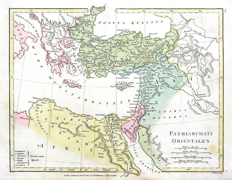
Map of the four Eastern Churches of the Pentarchy, AD c500. Almost all of modern Greece is in the jurisdiction of the Holy See of Rome. Emperor Leo III relocated the border of the Patriarchate of Constantinople westward during the 8th century..
| Description |
English: Map of the 4 Eastern Churches in the Pentarchy, circa 500CE |
| Date | (UTC) |
| Source | |
| Author |
The original uploader was Fredrick Wilhelm at English Wikipedia.
|
| This is a retouched picture, which means that it has been digitally altered from its original version. Modifications: Rectified, cropped, colors corrected. The original can be viewed here: 1800 Wilkinson Map of the 4 Eastern Churches.jpg:
|
|
This work is in the public domain in its country of origin and other countries and areas where the copyright term is the author's life plus 70 years or fewer. | |
| This file has been identified as being free of known restrictions under copyright law, including all related and neighboring rights. | |
Original upload log
[edit]
This image is a derivative work of the following images:
- File:1800_Wilkinson_Map_of_the_4_Eastern_Churches.jpg licensed with Cc-pd-mark-footer, PD-old
- 2010-08-24T08:50:03Z File Upload Bot (Magnus Manske) 1802x1378 (2039705 Bytes) {{BotMoveToCommons|en.wikipedia|year={{subst:CURRENTYEAR}}|month={{subst:CURRENTMONTHNAME}}|day={{subst:CURRENTDAY}}}} {{Information |Description={{en|Map of the 4 Eastern Churches in the Pentarchy, circa 500CE}} |Source=Tra
Uploaded with derivativeFX
File history
Click on a date/time to view the file as it appeared at that time.
| Date/Time | Thumbnail | Dimensions | User | Comment | |
|---|---|---|---|---|---|
| current | 20:47, 10 February 2016 | | 1,678 × 1,308 (895 KB) | Чръный человек (talk | contribs) | обработка |
| 18:04, 9 February 2016 |  | 1,678 × 1,308 (1.22 MB) | Чръный человек (talk | contribs) | Осветление | |
| 20:29, 1 May 2011 |  | 1,678 × 1,308 (1.91 MB) | MichaelBueker (talk | contribs) | color touchup | |
| 20:14, 1 May 2011 |  | 1,678 × 1,308 (1.61 MB) | MichaelBueker (talk | contribs) | {{Information |Description={{en|Map of the 4 Eastern Churches in the Pentarchy, circa 500CE}} |Source=*File:1800_Wilkinson_Map_of_the_4_Eastern_Churches.jpg |Date=2011-05-01 20:13 (UTC) |Author=*[[:File:1800_Wilkinson_Map_of_the_4_Eastern_Churches.j |
You cannot overwrite this file.
File usage on Commons
The following 3 pages use this file:
File usage on other wikis
The following other wikis use this file:
- Usage on ar.wikipedia.org
- Usage on arz.wikipedia.org
- Usage on az.wikipedia.org
- Usage on bg.wikipedia.org
- Usage on bn.wikipedia.org
- Usage on ckb.wikipedia.org
- Usage on cs.wikipedia.org
- Usage on el.wikipedia.org
- Usage on en.wikipedia.org
- Usage on eo.wikipedia.org
- Usage on es.wikipedia.org
- Usage on fa.wikipedia.org
- Usage on fr.wikipedia.org
- Usage on hu.wikipedia.org
- Usage on id.wikipedia.org
- Usage on it.wikipedia.org
- Usage on ko.wikipedia.org
- Usage on mk.wikipedia.org
- Usage on ml.wikipedia.org
- Usage on pt.wikipedia.org
- Usage on ru.wikipedia.org
- Usage on sk.wikipedia.org
- Usage on sr.wikipedia.org
- Usage on sv.wikipedia.org
- Usage on tr.wikipedia.org
- Usage on uk.wikipedia.org
View more global usage of this file.