File:1799 Clement Crutwell Map of Hindoostan - Geographicus - India-cruttwell-1799.jpg
Jump to navigation
Jump to search

Size of this preview: 505 × 600 pixels. Other resolutions: 202 × 240 pixels | 404 × 480 pixels | 647 × 768 pixels | 862 × 1,024 pixels | 1,724 × 2,048 pixels | 2,947 × 3,500 pixels.
Original file (2,947 × 3,500 pixels, file size: 2.51 MB, MIME type: image/jpeg)
Captions
Captions
Add a one-line explanation of what this file represents
| Hindoostan. | ||||||
|---|---|---|---|---|---|---|
| Artist | ||||||
| Title |
Hindoostan. |
|||||
| Description |
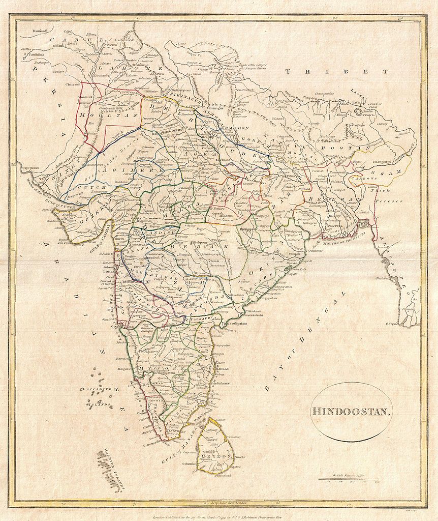
English: A fine 1799 map India, here labeled Hindoostan, by the English map publisher Clement Cruttwell. Covers the entire subcontinent and is divided into the various princely states. Though there is no specific reference to British dominance in the region, most of India had, at this juncture, fallen under the control of the British East India Company. Includes rivers, political boundaries, important cities, ports and gulfs. Mountains and other topographical features shown by profile. Outline color and fine copper plate engraving in the minimalist English style prevalent in the late 18th and early 19th centuries. Drawn by G. G. and J. Robinson of Paternoster Row, London, for Clement Cruttwell's 1799 Atlas to Cruttwell's Gazetteer. |
|||||
| Date | 1799 (dated) | |||||
| Dimensions | height: 16 in (40.6 cm); width: 13.7 in (34.9 cm) | |||||
| Accession number |
Geographicus link: India-cruttwell-1799 |
|||||
| Source/Photographer |
Cruttwell, C., Atlas to Cruttwell's Gazetteer, 1799.
|
|||||
| Permission (Reusing this file) |
|
|||||
File history
Click on a date/time to view the file as it appeared at that time.
| Date/Time | Thumbnail | Dimensions | User | Comment | |
|---|---|---|---|---|---|
| current | 11:45, 24 March 2011 | | 2,947 × 3,500 (2.51 MB) | BotMultichillT (talk | contribs) | {{subst:User:Multichill/Geographicus |link=http://www.geographicus.com/P/AntiqueMap/India-cruttwell-1799 |product_name=1799 Clement Crutwell Map of Hindoostan |map_title=Hindoostan. |description=A fine 1799 map India, here labeled Hindoostan, by the Engli |
You cannot overwrite this file.
File usage on Commons
The following page uses this file:
File usage on other wikis
The following other wikis use this file:
- Usage on nl.wiktionary.org