File:1794 Pownell Wall Map of North America and the West Indies - Geographicus - NorthAmerica-pownall-1794.jpg

Original file (6,000 × 5,175 pixels, file size: 8.37 MB, MIME type: image/jpeg)
Captions
Captions
| Artist | ||||||
| Title |
A New Map of North America with the West India Islands, divided according to the Preliminary Articles of Peace, Singed at Versailles, 20, jan 1783, wherein are particularly Distinguished The United States, and the Several Provinces, Governments & ca which Compose the British Dominions, Laid down according to the Latest Surveys, and Corrected from teh Original Materials of Goverr. Pownall, Membr. of Parlimt. |
|||||
| Description |
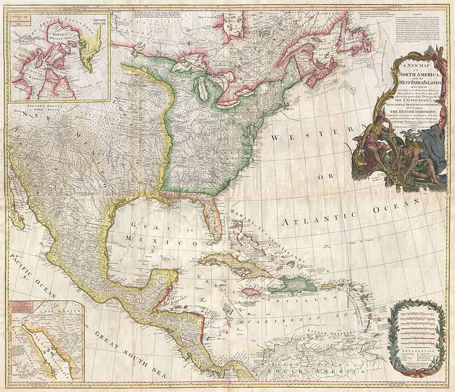
English: An extraordinary monumentally proportioned 1794 map of North American by Governor Pownell. Issued shortly after the end of the American Revolutionary War, this map details the newly formed United States, the British dominions in Canada, the French territory of Louisiana, the West Indies, and Spanish holdings in Mexico, Florida, and Central America. As one might expect from a map of this size the detail throughout is extraordinary. All text is in English. We begin our examination of this map in the newly formed post colonial United States. The United States at this time extended from the Pacific to the Mississippi River and from Georgia to the Great Lakes and Maine. The early state boundaries roughly conform to their original colonial charters. Virginia, North Carolina, and South Carolina are drawn with indefinite western borders, suggesting claims to further unexplored land beyond the Appellation Mountains. By this time most of the boundary issues in the New England states had been resolved, though there remained some vagaries regarding the Massachusetts Connecticut border and, though Vermont is noted textually, its boundaries are not drawn in. At this time there were also some unresolved issues regarding the national borders between Maine and Nova Scotia. In Pennsylvania, the western border displays some surveying confusions that would not be resolved until the early 1800s and the creation of Ohio. It is beyond the old colonial centers where this map really gets interesting. Pownall offers copious notations on the lands and territories between the Appellation range and this Mississippi River. In some cases he offers commentary on the various indigenous tribes including the Creeks, Chickasaws, Chocktaws, Senekas, Eriez, Delawares, Shawnee, Iroquois, Algonquians, Ottawas and others. The cartographer was clearly concerned with the development of these western regions and offers copious commentary on fit sites for factories, the alliances and temperaments of tribes, and the navigability of various river systems, particularly the Mississippi and Ohio. The Great Lakes are mapped with considerable accuracy though several apocryphal islands do appear in Lake Superior. The most notable of these are Phelipeaux and Pontchartrain. Phelipeaux Island first appeared in French maps of this region in the 1740s. Later it was mentioned as a boundary marker in the 1783 Treaty of Paris which ended the American Revolutionary War. The nonexistence of these islands was not conclusively proven until about 1820. To the west of the Mississippi we pass into the largely unknown lands of the Great Plains. In what is roughly modern day Missouri, between Memphis and St. Louis, there is an interesting note suggesting that this region is Full of Mines, with a secondary note suggesting that these mines gave rise to the Mississippi Scheme of 1719. This refers to the Mississippi Company ( Compagnie du Mississippi ) or, as it was more commonly known the Indies Company ( Compagnie d'Occident ). This organization was part of a French investment plan comparable to the South Seas Company which was developing contemporaneously in England. The Mississippi Company's charter was to trade the riches of the Louisiana Territory. The main proponent of the Mississippi Company, John Law, greatly exaggerated the wealth of Louisiana by describing a rich mining region easily accessible along the Mississippi from New Orleans. This resulted in a stock buying rush which disproportionately overvalued Mississippi Company stock, resulting in one of the world's first Bubble Economies. Further North, along the northern border between the United States and British America (Canada), Rain Lake, the Lake of the Woods, and Lake Winnepeg are noted. This region was a hotbed of exploration throughout the 18th century. |
|||||
| Date | 1794 (dated) | |||||
| Dimensions | height: 40 in (101.6 cm); width: 46 in (116.8 cm) | |||||
| Accession number |
Geographicus link: NorthAmerica-pownall-1794 |
|||||
| Source/Photographer |
Kitchin, Thomas, Kitchin's General Atlas, describing the Whole Universe: being a complete collection of the most approved maps extant; corrected with the greatest care, and augmented from the last edition of D'Anville and Robert with many improvements by other eminent geographers, engraved on Sixty-Two plates, comprising Thirty Seven maps., Laurie & Whittle, London, 1797.
|
|||||
| Permission (Reusing this file) |
|
|||||
File history
Click on a date/time to view the file as it appeared at that time.
| Date/Time | Thumbnail | Dimensions | User | Comment | |
|---|---|---|---|---|---|
| current | 04:26, 23 March 2011 | | 6,000 × 5,175 (8.37 MB) | BotMultichillT (talk | contribs) | {{subst:User:Multichill/Geographicus |link=http://www.geographicus.com/P/AntiqueMap/NorthAmerica-pownall-1794 |product_name=1794 Pownell Wall Map of North America and the West Indies |map_title=A New Map of North America with the West India Islands, divid |
You cannot overwrite this file.
File usage on Commons
The following page uses this file:
File usage on other wikis
The following other wikis use this file:
- Usage on fr.wikipedia.org