File:1780 Bonne Map of North Africa and the Western Mediterranean, Barbary Coast - Geographicus - BarbaryCoast-bonne-1780.jpg
Jump to navigation
Jump to search

Size of this preview: 800 × 525 pixels. Other resolutions: 320 × 210 pixels | 640 × 420 pixels | 1,024 × 673 pixels | 1,280 × 841 pixels | 2,500 × 1,642 pixels.
Original file (2,500 × 1,642 pixels, file size: 1.04 MB, MIME type: image/jpeg)
Captions
Captions
Add a one-line explanation of what this file represents
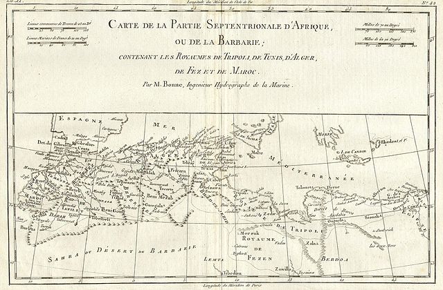
| Rigobert Bonne: North Africa and the Western Mediterranean: Barbary Coast.
( |
|||||||||||||||||||||||
|---|---|---|---|---|---|---|---|---|---|---|---|---|---|---|---|---|---|---|---|---|---|---|---|
| Artist |
|
||||||||||||||||||||||
| Title |
North Africa and the Western Mediterranean: Barbary Coast. |
||||||||||||||||||||||
| Description |
English: This remarkable map of North Africa’s Barbary Coast (Morocco, Algeria, Tunisia, Libya). Bonne was the successor to Bellin as head Engineer of the French Hydrographe del la Marine Department. This region is known for the terrible pirates who, for centuries, terrorized the Western Mediterranean. Towns, churches, cities and mountains are depicted as miniature representations of themselves. This map is highly detailed and beautifully crafted. |
||||||||||||||||||||||
| Date | 1780 | ||||||||||||||||||||||
| Dimensions | height: 9 in (22.8 cm); width: 13 in (33 cm) | ||||||||||||||||||||||
| Accession number |
Geographicus link: BarbaryCoast-bonne-1780 |
||||||||||||||||||||||
| Source/Photographer |
|
||||||||||||||||||||||
| Permission (Reusing this file) |
|
||||||||||||||||||||||
File history
Click on a date/time to view the file as it appeared at that time.
| Date/Time | Thumbnail | Dimensions | User | Comment | |
|---|---|---|---|---|---|
| current | 07:36, 16 March 2011 | | 2,500 × 1,642 (1.04 MB) | BotMultichill (talk | contribs) | {{subst:User:Multichill/Geographicus |link=http://www.geographicus.com/P/AntiqueMap/BarbaryCoast-bonne-1780 |product_name=1780 Bonne Map of North Africa and the Western Mediterranean: Barbary Coast |map_title=North Africa and the Western Mediterranean: Ba |
You cannot overwrite this file.
File usage on Commons
The following page uses this file:
File usage on other wikis
The following other wikis use this file:
- Usage on it.wikipedia.org