File:1777 Cook Map of the Friendly Islands or Tonga - Geographicus - FriendlyIsles-cook-1777.jpg
Jump to navigation
Jump to search

Size of this preview: 800 × 525 pixels. Other resolutions: 320 × 210 pixels | 640 × 420 pixels | 1,024 × 672 pixels | 1,280 × 841 pixels | 3,000 × 1,970 pixels.
Original file (3,000 × 1,970 pixels, file size: 1.54 MB, MIME type: image/jpeg)
Captions
Captions
Add a one-line explanation of what this file represents
| Chart of the Friendly Isles. | ||||||
|---|---|---|---|---|---|---|
| Artist | ||||||
| Title |
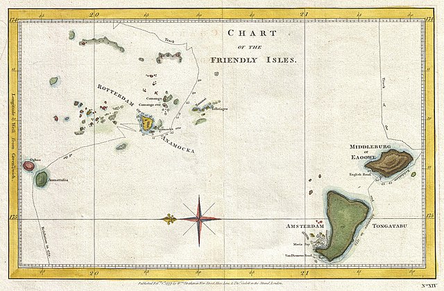
Chart of the Friendly Isles. |
|||||
| Description |
English: A highly uncommon chart of the Friendly Islands, or Tonga, from 1777. Oriented to the East, this map depicts the Tongatapu Island Group and the Ha'Apai Group that make up the Kingdom of Tonga. Shows the routes of the Resolution and the Adventure on Captain Cook's second voyage, 1772-1774. Cook's second voyage was intended to discover the apocryphal Terra Australis a theoretical southern continent that is not to be confused with Australia or Antarctica. On this voyage Cook crossed the Antarctic Circle and nearly, but not quite, spotted the Antarctic mainland. He landed at the Friendly Islands and laid on this map on the return portion of his voyage in 1773 and 1774. Published in 1777 by Thomas Cadell of London. |
|||||
| Date | 1777 (dated) | |||||
| Dimensions | height: 8.5 in (21.5 cm); width: 13 in (33 cm) | |||||
| Accession number |
Geographicus link: FriendlyIsles-cook-1777 |
|||||
| Source/Photographer |
Cook, James, A Voyage towards the South Pole, and Tound the World. Performed in His Majesty's ships the Resolution and Adventure, in the years 1772, 1773, 1774, and 1775, 2nd edition, London: Printed for W. Strahan; and T. Cadell in the Strand, 1777.
|
|||||
| Permission (Reusing this file) |
|
|||||
File history
Click on a date/time to view the file as it appeared at that time.
| Date/Time | Thumbnail | Dimensions | User | Comment | |
|---|---|---|---|---|---|
| current | 05:14, 23 March 2011 | | 3,000 × 1,970 (1.54 MB) | BotMultichillT (talk | contribs) | {{subst:User:Multichill/Geographicus |link=http://www.geographicus.com/P/AntiqueMap/FriendlyIsles-cook-1777 |product_name=1777 Cook Map of the Friendly Islands or Tonga |map_title=Chart of the Friendly Isles. |description=A highly uncommon chart of the Fr |
You cannot overwrite this file.
File usage on Commons
The following page uses this file:
File usage on other wikis
The following other wikis use this file:
- Usage on en.wikipedia.org
- Usage on fr.wikipedia.org