File:1775 Janvier Map of Holland and Belgium - Geographicus - HollandBelgium-janvier-1775.jpg
Jump to navigation
Jump to search
Size of this preview: 800 × 568 pixels. Other resolutions: 320 × 227 pixels | 640 × 455 pixels | 1,024 × 728 pixels | 1,280 × 910 pixels | 2,560 × 1,819 pixels | 3,500 × 2,487 pixels.
Original file (3,500 × 2,487 pixels, file size: 2.79 MB, MIME type: image/jpeg)
Captions
Captions
Add a one-line explanation of what this file represents
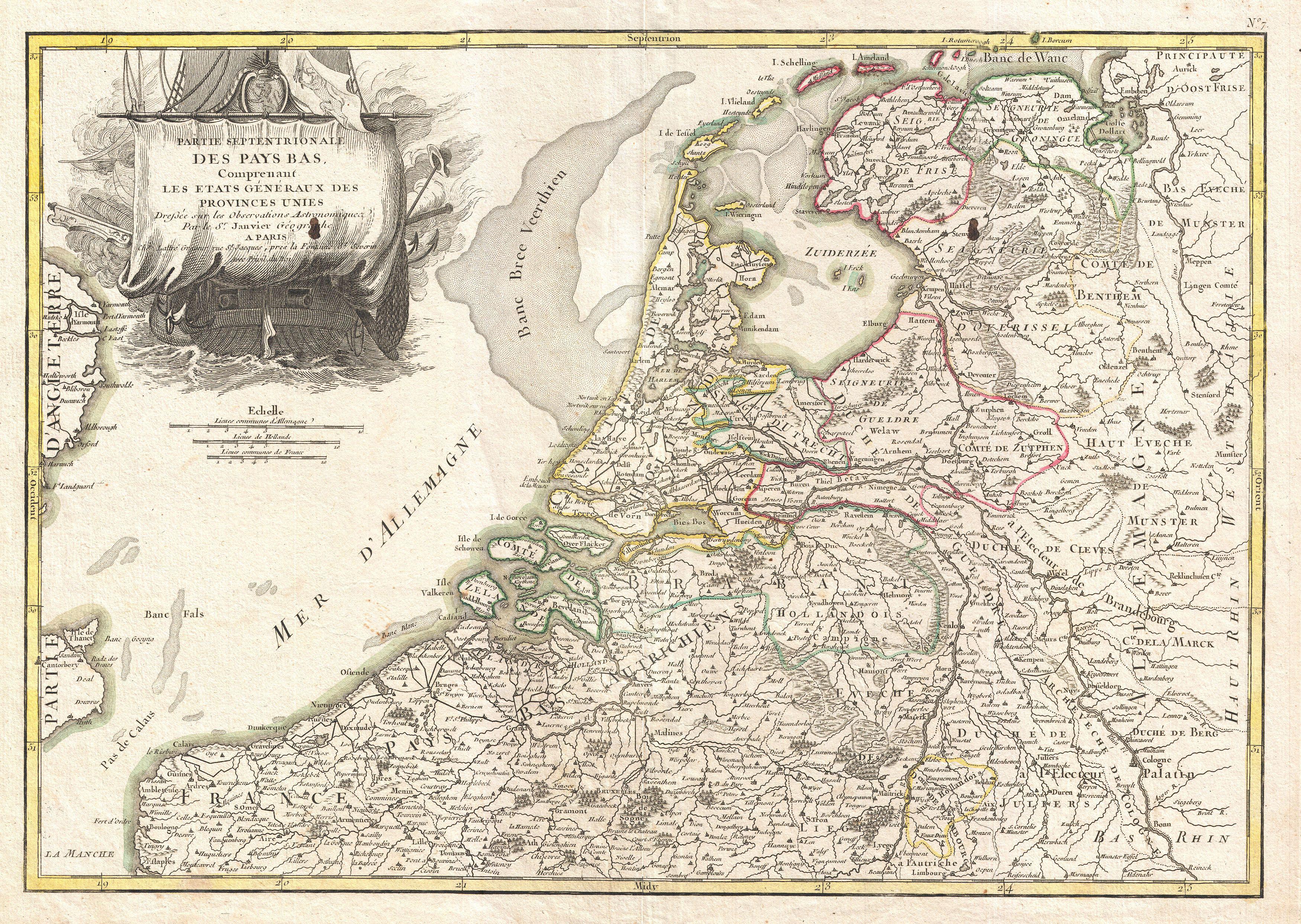
| Jean Janvier: Partie Septentrionale des Pays Bas, Comprenant Les Etats Generaus des Provinces Unies.
( |
|||||||||||||||||
|---|---|---|---|---|---|---|---|---|---|---|---|---|---|---|---|---|---|
| Artist |
|
||||||||||||||||
| Title |
Partie Septentrionale des Pays Bas, Comprenant Les Etats Generaus des Provinces Unies. |
||||||||||||||||
| Description |
English: A beautiful example of Jan Janvier's decorative map of the Low Countries or Pays Bas. Covers modern day Holland and Belgium from Friesland south to France, west to England, and east to Germany. Offers excellent detail throughout showing mountains, rivers, forests, national boundaries, regional boundaries, forts, and cities. Offers some undersea detail. A large decorative title cartouche depicting a merchant ship appears in the upper left quadrant. Drawn by Jan Janvier around 1775 for issue as plate no. 7 in Jean Lattre's 1776 issue of the Atlas Moderne . |
||||||||||||||||
| Date | 1775 (undated) | ||||||||||||||||
| Dimensions | height: 12.5 in (31.7 cm); width: 17.5 in (44.4 cm) | ||||||||||||||||
| Accession number |
Geographicus link: HollandBelgium-janvier-1775 |
||||||||||||||||
| Source/Photographer |
Lattre, Jean, Atlas Moderne ou Collection de Cartes sur Toutes les Parties du Globe Terrestre, c. 1775.
|
||||||||||||||||
| Permission (Reusing this file) |
|
||||||||||||||||
File history
Click on a date/time to view the file as it appeared at that time.
| Date/Time | Thumbnail | Dimensions | User | Comment | |
|---|---|---|---|---|---|
| current | 17:40, 23 March 2011 | | 3,500 × 2,487 (2.79 MB) | BotMultichillT (talk | contribs) | {{subst:User:Multichill/Geographicus |link=http://www.geographicus.com/P/AntiqueMap/HollandBelgium-janvier-1775 |product_name=1775 Janvier Map of Holland and Belgium |map_title=Partie Septentrionale des Pays Bas, Comprenant Les Etats Generaus des Province |
You cannot overwrite this file.
File usage on Commons
The following 2 pages use this file: