File:1775 Boston Map - Liberty Tree.jpg
Jump to navigation
Jump to search

Size of this preview: 637 × 600 pixels. Other resolutions: 255 × 240 pixels | 510 × 480 pixels | 850 × 800 pixels.
Original file (850 × 800 pixels, file size: 345 KB, MIME type: image/jpeg)
Captions
Captions
Add a one-line explanation of what this file represents
Summary
[edit]
| Description |
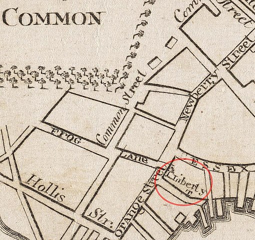
English: Map of Boston in 1775, showing the location of the Liberty Tree, near the corner of Orange (now Washington) and Essex Streets, in the vicinity of the Boston Common and Frog Lane (now Boylston Street).
Derived from "Boston (Mass.), Boston and vicinity," by Robert Aitken. |
| Date | |
| Source | Boston Public Library. http://maps.bpl.org/id/10031 |
| Author | Robert Aitken |
| Camera location | | View this and other nearby images on: OpenStreetMap |
|---|
Licensing
[edit]
This media file is in the public domain in the United States. This applies to U.S. works where the copyright has expired, often because its first publication occurred prior to January 1, 1929, and if not then due to lack of notice or renewal. See this page for further explanation.
|
 | |
 |
This image might not be in the public domain outside of the United States; this especially applies in the countries and areas that do not apply the rule of the shorter term for US works, such as Canada, Mainland China (not Hong Kong or Macao), Germany, Mexico, and Switzerland. The creator and year of publication are essential information and must be provided. See Wikipedia:Public domain and Wikipedia:Copyrights for more details.
|
File history
Click on a date/time to view the file as it appeared at that time.
| Date/Time | Thumbnail | Dimensions | User | Comment | |
|---|---|---|---|---|---|
| current | 01:07, 5 December 2014 | | 850 × 800 (345 KB) | Ro4444 (talk | contribs) | User created page with UploadWizard |
You cannot overwrite this file.
File usage on Commons
There are no pages that use this file.