File:1771 Bonne Map of the Auvergne, Limosin, Bourbonnais, and Berri, France - Geographicus - Auvergne-bonne-1771.jpg
Jump to navigation
Jump to search

Size of this preview: 421 × 599 pixels. Other resolutions: 169 × 240 pixels | 337 × 480 pixels | 540 × 768 pixels | 720 × 1,024 pixels | 2,461 × 3,500 pixels.
Original file (2,461 × 3,500 pixels, file size: 3.02 MB, MIME type: image/jpeg)
Captions
Captions
Add a one-line explanation of what this file represents
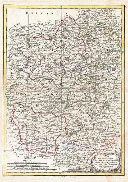
| Rigobert Bonne: Carte dus Gouvernements du Berri, du Nivernois, de la Marche, du Bourbonnois, du Limosin et de L'Auvergne.
( |
|||||||||||||||||||||||
|---|---|---|---|---|---|---|---|---|---|---|---|---|---|---|---|---|---|---|---|---|---|---|---|
| Artist |
|
||||||||||||||||||||||
| Title |
Carte dus Gouvernements du Berri, du Nivernois, de la Marche, du Bourbonnois, du Limosin et de L'Auvergne. |
||||||||||||||||||||||
| Description |
English: A beautiful example of Rigobert Bonne's decorative map of the French regions of Berri, Nivernois, Marche, Bourbonnais, Limosin and Auvergne. A large decorative title cartouche appears in the lower right quadrant. Drawn by R. Bonne in 1771 for issue as plate no. I 5 in Jean Lattre's 1776 issue of the Atlas Moderne . |
||||||||||||||||||||||
| Date | 1771 (dated) | ||||||||||||||||||||||
| Dimensions | height: 16.5 in (41.9 cm); width: 12 in (30.4 cm) | ||||||||||||||||||||||
| Accession number |
Geographicus link: Auvergne-bonne-1771 |
||||||||||||||||||||||
| Source/Photographer |
Lattre, Jean, Atlas Moderne ou Collection de Cartes sur Toutes les Parties du Globe Terrestre, c. 1775.
|
||||||||||||||||||||||
| Permission (Reusing this file) |
|
||||||||||||||||||||||
File history
Click on a date/time to view the file as it appeared at that time.
| Date/Time | Thumbnail | Dimensions | User | Comment | |
|---|---|---|---|---|---|
| current | 18:26, 23 March 2011 | | 2,461 × 3,500 (3.02 MB) | BotMultichillT (talk | contribs) | {{subst:User:Multichill/Geographicus |link=http://www.geographicus.com/P/AntiqueMap/Auvergne-bonne-1771 |product_name=1771 Bonne Map of the Auvergne, Limosin, Bourbonnais, and Berri, France |map_title=Carte dus Gouvernements du Berri, du Nivernois, de la |
You cannot overwrite this file.
File usage on Commons
The following page uses this file: