File:1770 Bauerschaft Bathey.png
Jump to navigation
Jump to search

Size of this preview: 800 × 445 pixels. Other resolutions: 320 × 178 pixels | 640 × 356 pixels | 1,024 × 570 pixels | 1,546 × 860 pixels.
Original file (1,546 × 860 pixels, file size: 2.27 MB, MIME type: image/png)
Captions
Captions
Add a one-line explanation of what this file represents
Summary
[edit]
| Description |
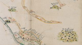
Deutsch: Ausschnitt aus der Karte „Vermessung und Teilung der Boeler Mark“. Zeichnung von Johann Heinrich Merner, 1770. Rechts die Bauerschaft Bathey, links die Lenne und Kabel. |
| Date | |
| Source | Landesarchiv NRW Abteilung Westfalen W 051 / Karten A (Allgemein), Nr. 7386, 1770 – DFG-Viewer |
| Author | Johann Heinrich Merner |
Licensing
[edit]
|
This work is in the public domain in its country of origin and other countries and areas where the copyright term is the author's life plus 100 years or fewer. This work is in the public domain in the United States because it was published (or registered with the U.S. Copyright Office) before January 1, 1929. | |
| This file has been identified as being free of known restrictions under copyright law, including all related and neighboring rights. | |
File history
Click on a date/time to view the file as it appeared at that time.
| Date/Time | Thumbnail | Dimensions | User | Comment | |
|---|---|---|---|---|---|
| current | 13:38, 23 March 2021 | | 1,546 × 860 (2.27 MB) | Bärwinkel,Klaus (talk | contribs) | {{Information |Description={{de|1=Ausschnitt aus der Karte „Vermessung und Teilung der Boeler Mark“. Zeichnung von Johann Heinrich Merner, 1770. Rechts die Bauerschaft Bathey, links die Lenne und Kabel.}} |Source=Landesarchiv NRW Abteilung Westfalen W 051 / Karten A (Allgemein), Nr. 7386, 1770 |Date=1770 |Author=Landesarchiv NRW Abt. Westfalen – DFG-Viewer |Permission= |other_versions= }} == {{int:license}} == {{free screenshot|license={{GPL}} }} Category:Bathey |
You cannot overwrite this file.
File usage on Commons
There are no pages that use this file.