File:1759 chateau de boëzenbourg.jpg
Jump to navigation
Jump to search

Size of this preview: 800 × 493 pixels. Other resolutions: 320 × 197 pixels | 640 × 394 pixels | 1,024 × 631 pixels | 1,280 × 789 pixels | 2,560 × 1,578 pixels | 4,295 × 2,647 pixels.
Original file (4,295 × 2,647 pixels, file size: 1.88 MB, MIME type: image/jpeg)
Captions
Captions
Add a one-line explanation of what this file represents
Summary
[edit]| Description |
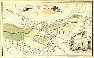
Deutsch: Lageplan Schloß Boitzenburg vom schwedischen Kriegsarchiv |
||||||||||||||||||||||||||
| Date | |||||||||||||||||||||||||||
| Source |
Utländska stads- och fästningsplaner, Boitzenburg, SE/KrA/0406/25/018/001 (1759), bildid: K0007390_00001 https://sok.riksarkivet.se/arkiv/cGhHSyXtugJ5mireLGJFL2 |
||||||||||||||||||||||||||
| Author | Unknown author | ||||||||||||||||||||||||||
| Permission (Reusing this file) |
|
||||||||||||||||||||||||||


|
This work is in the public domain in its country of origin and other countries and areas where the copyright term is the author's life plus 100 years or fewer. | |
| This file has been identified as being free of known restrictions under copyright law, including all related and neighboring rights. | |
File history
Click on a date/time to view the file as it appeared at that time.
| Date/Time | Thumbnail | Dimensions | User | Comment | |
|---|---|---|---|---|---|
| current | 10:01, 17 August 2022 | | 4,295 × 2,647 (1.88 MB) | DivadH (talk | contribs) | Radically increased resolution compared to previous file |
| 09:39, 8 June 2018 |  | 987 × 607 (91 KB) | Ralf Roletschek (talk | contribs) | {{Information |description={{de|Lageplan Schloß Boitzenburg vom schwedischen Kriegsarchiv}} |source=https://archive.is/20121227010244/http://62.20.57.210/kra/bilder/0406/25/018_001.jpg |date=1759 |author=unbekannt |permission= |other versions= }} {{PD-old-100}} Category:Schloss Boitzenburg |
You cannot overwrite this file.
File usage on Commons
The following page uses this file:
File usage on other wikis
The following other wikis use this file:
- Usage on de.wikipedia.org