File:1740 Seutter Map of Swabia and Wirtenberg, Germany - Geographicus - Suevicus-seutter-1740.jpg
Jump to navigation
Jump to search

Size of this preview: 683 × 599 pixels. Other resolutions: 274 × 240 pixels | 547 × 480 pixels | 875 × 768 pixels | 1,167 × 1,024 pixels | 2,334 × 2,048 pixels | 5,000 × 4,388 pixels.
Original file (5,000 × 4,388 pixels, file size: 9.54 MB, MIME type: image/jpeg)
Captions
Captions
Add a one-line explanation of what this file represents
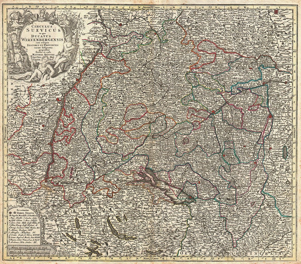
| Matthäus Seuttetre: Circulus Suevicus in quo Ducatus Wirtenbergensis cum reliquis Statibus et Provinciis curate defiguatus propomtur Studio et eaelo Matthaei Seutteri.
( |
||||||||||||||||||||||||
|---|---|---|---|---|---|---|---|---|---|---|---|---|---|---|---|---|---|---|---|---|---|---|---|---|
| Artist |
|
|||||||||||||||||||||||
| Title |
Circulus Suevicus in quo Ducatus Wirtenbergensis cum reliquis Statibus et Provinciis curate defiguatus propomtur Studio et eaelo Matthaei Seutteri. |
|||||||||||||||||||||||
| Description |
English: This is a rare c. 1740 map of Swabia and Wittenberg, Germany. Covers from Strasburg eastward as far as Landsperg, north as far as Nuremberg and south to Lucern. Includes Nuremberg, Heidelberg, Strasburg, Manheim, Lucerne (Lucern, Luzern), Boden See, and Stuttgart. Detail includes cities, forts, some topographical features, and districts. Decorative title cartouche in the upper left quadrant featuring the instruments of science and symbols of bounty. Prepared by Matthaeus Seutter and issued in Augsburg as plate no. 11 in Homann Heirs’ Maior Atlas Scholasticus . |
|||||||||||||||||||||||
| Date | circa 1740(undated) | |||||||||||||||||||||||
| Dimensions | height: 19.7 in (50.1 cm); width: 22.5 in (57.1 cm) | |||||||||||||||||||||||
| Accession number |
Geographicus link: Suevicus-seutter-1740 |
|||||||||||||||||||||||
| Source/Photographer |
Major Atlas Scholasticus Ex Triginta sex Generalibus et Specialibus Mappis Homannianis..., c. 1740.
|
|||||||||||||||||||||||
| Permission (Reusing this file) |
|
|||||||||||||||||||||||
| Other versions |
|
|||||||||||||||||||||||


File history
Click on a date/time to view the file as it appeared at that time.
| Date/Time | Thumbnail | Dimensions | User | Comment | |
|---|---|---|---|---|---|
| current | 20:33, 16 March 2011 | | 5,000 × 4,388 (9.54 MB) | BotMultichill (talk | contribs) | {{subst:User:Multichill/Geographicus |link=http://www.geographicus.com/P/AntiqueMap/Suevicus-seutter-1740 |product_name=1740 Seutter Map of Swabia and Wirtenberg, Germany |map_title=Circulus Suevicus in quo Ducatus Wirtenbergensis cum reliquis Statibus et |
You cannot overwrite this file.
File usage on Commons
The following 2 pages use this file:
File usage on other wikis
The following other wikis use this file:
- Usage on de.wikipedia.org