File:1729 Goteborg masthamnen.jpg
Jump to navigation
Jump to search

Size of this preview: 800 × 548 pixels. Other resolutions: 320 × 219 pixels | 640 × 439 pixels | 1,024 × 702 pixels | 1,280 × 877 pixels | 2,560 × 1,755 pixels | 3,357 × 2,301 pixels.
Original file (3,357 × 2,301 pixels, file size: 1.5 MB, MIME type: image/jpeg)
Captions
Captions
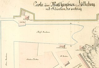
Masthamnen (The mast port) in Goteborg, Sweden on a map from 1729
Summary
[edit]
| Description |
English: Masthamnen (The mast port) in Goteborg, Sweden on a map from 1729
Ab: Masthamnen i Göteborg, på en karta från 1729. Hamnen låg precis innanför befästningsmurarna vid nuvarande Packhusplatsen, mellan Stora Hamnkanalen och Kvarnberget. |
| Date | |
| Source | https://arkeologerna.com/bloggar/arkeologi-i-goteborg/masthamnen-och-tullomradet/ |
| Author | Unknown (map from 1729) |
Licensing
[edit]
|
This work is in the public domain in its country of origin and other countries and areas where the copyright term is the author's life plus 70 years or fewer. This work is in the public domain in the United States because it was published (or registered with the U.S. Copyright Office) before January 1, 1929. | |
| This file has been identified as being free of known restrictions under copyright law, including all related and neighboring rights. | |
File history
Click on a date/time to view the file as it appeared at that time.
| Date/Time | Thumbnail | Dimensions | User | Comment | |
|---|---|---|---|---|---|
| current | 13:20, 30 March 2023 | | 3,357 × 2,301 (1.5 MB) | AHA (talk | contribs) | Uploaded a work by Unknown (map from 1729) from https://arkeologerna.com/bloggar/arkeologi-i-goteborg/masthamnen-och-tullomradet/ with UploadWizard |
You cannot overwrite this file.
File usage on Commons
There are no pages that use this file.
File usage on other wikis
The following other wikis use this file:
- Usage on sv.wikipedia.org