File:1725 Walmer castle plan rotated.jpg
Jump to navigation
Jump to search

Size of this preview: 642 × 600 pixels. Other resolutions: 257 × 240 pixels | 514 × 480 pixels | 822 × 768 pixels | 1,096 × 1,024 pixels | 1,953 × 1,824 pixels.
Original file (1,953 × 1,824 pixels, file size: 1.32 MB, MIME type: image/jpeg)
Captions
Captions
Add a one-line explanation of what this file represents
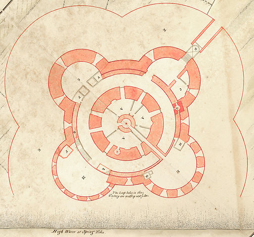
| Description | 1725 map of Walmer Castle, Kent - shortly before rebuilding into the Duke of Kent apartments. |
| Date | |
| Source | Cropped and rotated from the original: The British Library, King George Ill’s Topographical Collection, http://www.bl.uk/onlinegallery/onlineex/kinggeorge/p/003ktop00000018u05900000.html |
| Author | Unknown (probably British Navy staff) |
| Other versions |
 |
|
This work is in the public domain in its country of origin and other countries and areas where the copyright term is the author's life plus 100 years or fewer. | |
| This file has been identified as being free of known restrictions under copyright law, including all related and neighboring rights. | |
File history
Click on a date/time to view the file as it appeared at that time.
| Date/Time | Thumbnail | Dimensions | User | Comment | |
|---|---|---|---|---|---|
| current | 08:20, 27 February 2014 | | 1,953 × 1,824 (1.32 MB) | Retired electrician (talk | contribs) | {{Information |Description=1725 map of Walmer Castle, Kent - shortly before rebuilding into the Duke of Kent apartments. |Source=Cropped and rotated from the original: The British Library, King George Ill’s Topographical Collection, http://www.bl.uk/... |
You cannot overwrite this file.
File usage on Commons
The following page uses this file:
File usage on other wikis
The following other wikis use this file:
- Usage on ru.wikipedia.org