File:1719 Carte de l'Empire Othoman Consideree dans les Etats de Cette Puissance... a l'Histoire d'Alexandre le Grand.jpg
Jump to navigation
Jump to search

Size of this preview: 800 × 340 pixels. Other resolutions: 320 × 136 pixels | 640 × 272 pixels | 1,024 × 435 pixels | 1,280 × 544 pixels | 2,560 × 1,088 pixels | 9,772 × 4,153 pixels.
Original file (9,772 × 4,153 pixels, file size: 19.04 MB, MIME type: image/jpeg)
Captions
Captions
Add a one-line explanation of what this file represents
Summary
[edit]
| Description |
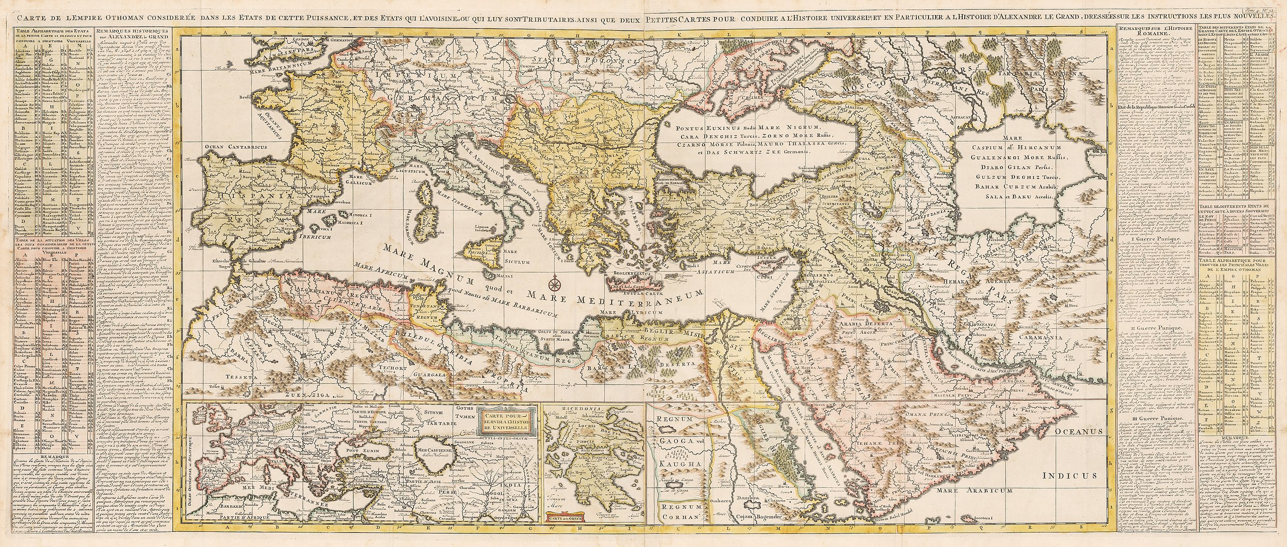
Français : Carte de l'Empire Othoman Consideree dans les Etats de Cette Puissance, et des Etats qui L'avoisine ou qui luy sont Tributaries ainsi que deux Petites Cartes pour conduire a l'Histoire universel, et a l'Histoire d'Alexandre le Grand dressées sur les instructions les plus nouvelles. Dimension: 50.2 cm x 120.5 cm. English: This is an authentic, antique map showing the reaches of the Ottoman Empire at the height of its power with comparisons to the Empires of Alexander the Great and the Romans. The map was published out of Amsterdam by Henri Abraham Chatelain circa 1719. This impressive map is one of the only maps of its era to cover the entire Ottoman Empire. From southern Europe and Northern Africa, the map extends as far east to include the Arabian Peninsula, Persia and the Caspian Sea. Two insert maps include a smaller version of the map extending a bit further east to include the Ganges River, and a map of Greece that notes Macedonia (the birthplace of Alexander the Great). The map pays great attention to detail noting hundreds of towns and large cities, mountain ranges, and river systems. On either side of the map are extensive tables noting the exact locations of important towns and states throughout the map. Also included alongside the tables are lengthy descriptions recounting the history of Alexander the Great and the Roman Empire. |
| Date | |
| Source |
Français : Atlas Historique, ou Nouvelle Introduction á l'Histoire, à la Chronologie & à la Geographie Ancienne & Moderne: le volume V. Amsterdam: L'Honoré & Châtelain, 1719.
|
| Author |
English: Henri Abraham Chatelain (1684 - 1743): he was a Huguenot pastor of Parisian origins. He lived consecutively in Paris, St. Martins, London (c. 1710), The Hague (c. 1721) and Amsterdam (c. 1728). He is best known as a Dutch cartographer and more specifically for his cartographic contribution in the seminal seven volume Atlas Historique, published in Amsterdam between 1705 and 1720. Innovative for its time, the maps in the Atlas Historique were mainly based on those of the French cartographer, Guillaume De L’Isle, but were presented by the Chatelains in an encyclopaedic form. The maps were accompanied by information pertaining to cosmography, geography, history, chronology, genealogy, topography, heraldry, and costume of the world.. Some scholarship suggests that the Atlas Historique was not exclusively compiled by Henri Chatelain, as is commonly believed, but rather was a family enterprise involving Henri, his father Zacharie and his brother, also Zacharie. |
Licensing
[edit]
|
This is a faithful photographic reproduction of a two-dimensional, public domain work of art. The work of art itself is in the public domain for the following reason:
The official position taken by the Wikimedia Foundation is that "faithful reproductions of two-dimensional public domain works of art are public domain".
This photographic reproduction is therefore also considered to be in the public domain in the United States. In other jurisdictions, re-use of this content may be restricted; see Reuse of PD-Art photographs for details. | ||||
File history
Click on a date/time to view the file as it appeared at that time.
| Date/Time | Thumbnail | Dimensions | User | Comment | |
|---|---|---|---|---|---|
| current | 08:22, 24 May 2015 | | 9,772 × 4,153 (19.04 MB) | Sabuhi from Baku (talk | contribs) | User created page with UploadWizard |
You cannot overwrite this file.
File usage on Commons
There are no pages that use this file.