File:171014 Aussichtsturm Pferdskopf 1.jpg
Jump to navigation
Jump to search

Size of this preview: 450 × 600 pixels. Other resolutions: 180 × 240 pixels | 360 × 480 pixels | 576 × 768 pixels | 768 × 1,024 pixels | 2,448 × 3,264 pixels.
Original file (2,448 × 3,264 pixels, file size: 4.38 MB, MIME type: image/jpeg)
Captions
Captions
Add a one-line explanation of what this file represents
Summary
[edit]
| Description |
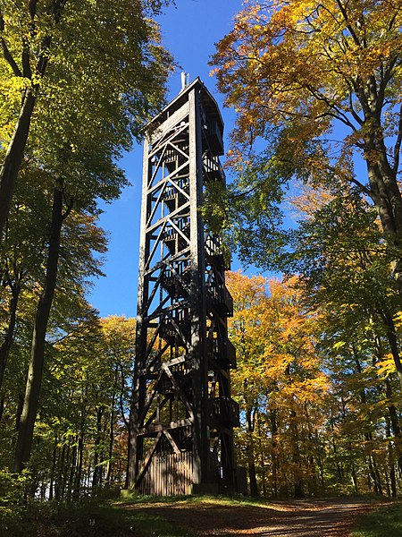
Deutsch: Von 1895 bis ca. 1960 stand hier auf dem 662,6 Meter hohen Berg "Pferdskopf" schon mal ein 18 Meter hoher Turm, damals aus Stahl und vom Taunusklub errichtet.
Der heute vorhandene Turm, 34 Meter hoch, wurde vom Umlandverband Frankfurt in offener Holz-Fachwerk-Konstruktion wiedererrichtet und am 10. November 1987 der Gemeinde Schmitten übergeben. Unten am Turm stehen Tische und Bänke für eine Rast.English: The Pferdskopf is a 662.6 meter high mountain.
At his summit was formerly a 18 meter high tower from 1895 to 1960 made from steel. The current tower is 34 meter high made from wood in the year 1987. At his bottom you will find a rest area. |
| Date | |
| Source | Own work |
| Author | 4spring |
| Camera location | | View this and other nearby images on: OpenStreetMap |
|---|
Licensing
[edit]
I, the copyright holder of this work, hereby publish it under the following license:
| This file is made available under the Creative Commons CC0 1.0 Universal Public Domain Dedication. | |
| The person who associated a work with this deed has dedicated the work to the public domain by waiving all of their rights to the work worldwide under copyright law, including all related and neighboring rights, to the extent allowed by law. You can copy, modify, distribute and perform the work, even for commercial purposes, all without asking permission.
|
File history
Click on a date/time to view the file as it appeared at that time.
| Date/Time | Thumbnail | Dimensions | User | Comment | |
|---|---|---|---|---|---|
| current | 19:29, 15 November 2017 | | 2,448 × 3,264 (4.38 MB) | 4spring (talk | contribs) | User created page with UploadWizard |
You cannot overwrite this file.
File usage on Commons
There are no pages that use this file.
File usage on other wikis
The following other wikis use this file:
- Usage on en.wikipedia.org