File:1701-E.Halley World Chart of the equal declination.jpg
Jump to navigation
Jump to search
Size of this preview: 800 × 336 pixels. Other resolutions: 320 × 134 pixels | 640 × 269 pixels | 1,609 × 676 pixels.
Original file (1,609 × 676 pixels, file size: 944 KB, MIME type: image/jpeg)
Captions
Captions
Add a one-line explanation of what this file represents
Summary
[edit]| Description |
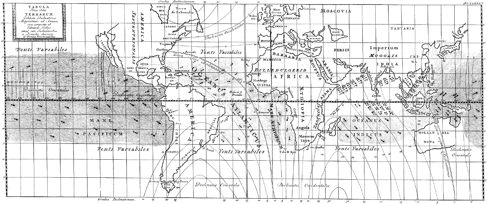
Русский: Карта магнитных полей. Галлей, 1701.
English: World Chart of the equal declination. E. Halley, 1701 |
| Date | |
| Source | Halley E. Tabula Totius Orbis Terrarum Exhibens Declinationes Magneticas, ad Annum 1700 composita ab Edmundo Halleyo Simul cum Inclinationibus a Poundio Observatis et Ventis Universalibus, Paris. 1701. |
| Author | Halley E. |
| Other versions |
|
.jpg)


Licensing
[edit]
|
This work is in the public domain in its country of origin and other countries and areas where the copyright term is the author's life plus 70 years or fewer. This work is in the public domain in the United States because it was published (or registered with the U.S. Copyright Office) before January 1, 1929. | |
| This file has been identified as being free of known restrictions under copyright law, including all related and neighboring rights. | |
File history
Click on a date/time to view the file as it appeared at that time.
| Date/Time | Thumbnail | Dimensions | User | Comment | |
|---|---|---|---|---|---|
| current | 10:45, 23 August 2016 | | 1,609 × 676 (944 KB) | Ivtorov (talk | contribs) | User created page with UploadWizard |
You cannot overwrite this file.
File usage on Commons
The following 4 pages use this file:
- File:Accuratissima totius terrarum orbis tabula nautica - celeberrimo viro Edmd. Halley, LLD., anno 1700 contructa; indice variationes magneticas denota(m?) ad observationes circiter annu 1744 habitas NYPL465004.tiff
- File:Nova & accuratissima totius terrarum orbis tabula nautica variationum magneticarum index juxta observationes Anno 1700 (NYPL b13909432-1640713).jpg
- File:Nova and accuratissima totius terrarum orbis tabula nautica variationum magneticarum index juxta observationes Anno 1700 - habitas constructa per Edm. Halley NYPL1640713.jpg
- File:Nova and accuratissima totius terrarum orbis tabula nautica variationum magneticarum index juxta observationes Anno 1700 - habitas constructa per Edm. Halley NYPL1640713.tiff