File:1683 LaSalle, Carte de la Louisiane.png
Jump to navigation
Jump to search
No higher resolution available.
1683_LaSalle,_Carte_de_la_Louisiane.png (655 × 466 pixels, file size: 553 KB, MIME type: image/png)
Captions
Captions
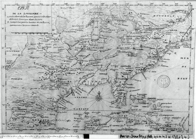
Earliest map with Chicago word. Map by La Salle.
Summary
[edit]
| Description |
English: This map, associated with Jean-Baptiste Minet and the year 1685, is better attributed to La Salle, 1683. Well documented in the Newberry Ayer catalogue that the map (as Minet 1685) was based on Franquelin's 1684 map of North America, and further documented on the Franquelin Map Cartouche, itself, is that the map was based on La Salle's voyages and discoveries. |
| Date | |
| Source | http://earliestchicagomaps.com/images/imagesECM-Small/1683LaSalle-MinetLarge.jpg |
| Author | La Salle |
Licensing
[edit]
|
This work is in the public domain in its country of origin and other countries and areas where the copyright term is the author's life plus 70 years or fewer. This work is in the public domain in the United States because it was published (or registered with the U.S. Copyright Office) before January 1, 1929. | |
| This file has been identified as being free of known restrictions under copyright law, including all related and neighboring rights. | |
File history
Click on a date/time to view the file as it appeared at that time.
| Date/Time | Thumbnail | Dimensions | User | Comment | |
|---|---|---|---|---|---|
| current | 19:44, 5 March 2020 | | 655 × 466 (553 KB) | Carl J. Weber (talk | contribs) | Uploaded a work by La Salle from http://earliestchicagomaps.com/images/imagesECM-Small/1683LaSalle-MinetLarge.jpg with UploadWizard |
You cannot overwrite this file.
File usage on Commons
There are no pages that use this file.