File:1634 Virginia Counties- Henrico Focus.jpg
Jump to navigation
Jump to search

Size of this preview: 800 × 522 pixels. Other resolutions: 320 × 209 pixels | 640 × 418 pixels | 922 × 602 pixels.
Original file (922 × 602 pixels, file size: 229 KB, MIME type: image/jpeg)
Captions
Captions
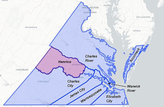
Map of the original 8 shires of Virginia, established in 1634, with Henrico shire emphasized
Summary
[edit]
| Description |
English: This file is a map of the first 8 shires created in Virginia in 1634. The base of this map was taken from the Newberry Library Atlas of Historical County Boundaries for Virginia 1634-12-31., and is copyrighted for commercial and non-commerical distribution (see linked page). File also includes my added coloration for Henrico, as well as addition of County names. Note: The underlying map of Virginia is contemporary map and not reflective of the settlement in 1634. |
| Date | |
| Source | Own work |
| Author | Wtfiv |
Licensing
[edit]
I, the copyright holder of this work, hereby publish it under the following license:
This file is licensed under the Creative Commons Attribution-Share Alike 4.0 International license.
- You are free:
- to share – to copy, distribute and transmit the work
- to remix – to adapt the work
- Under the following conditions:
- attribution – You must give appropriate credit, provide a link to the license, and indicate if changes were made. You may do so in any reasonable manner, but not in any way that suggests the licensor endorses you or your use.
- share alike – If you remix, transform, or build upon the material, you must distribute your contributions under the same or compatible license as the original.
File history
Click on a date/time to view the file as it appeared at that time.
| Date/Time | Thumbnail | Dimensions | User | Comment | |
|---|---|---|---|---|---|
| current | 18:28, 2 April 2020 | | 922 × 602 (229 KB) | Wtfiv (talk | contribs) | Uploaded own work with UploadWizard |
You cannot overwrite this file.
File usage on Commons
There are no pages that use this file.
File usage on other wikis
The following other wikis use this file:
- Usage on en.wikipedia.org
- Usage on www.wikidata.org