File:1413 - Brewarrina Aboriginal Fish Traps - Baiame's Ngunnhu - Fish ladder constructed in rocks beside weir to allow native fish to swim upstream, completed in 2013 (5051305b5).jpg
Jump to navigation
Jump to search
No higher resolution available.
1413_-_Brewarrina_Aboriginal_Fish_Traps_-_Baiame's_Ngunnhu_-_Fish_ladder_constructed_in_rocks_beside_weir_to_allow_native_fish_to_swim_upstream,_completed_in_2013_(5051305b5).jpg (640 × 361 pixels, file size: 82 KB, MIME type: image/jpeg)
Captions
Captions
Add a one-line explanation of what this file represents
| Camera location | | View this and other nearby images on: OpenStreetMap |
|---|
.jpg¶ms=-29.958053_N_0146.857435_E_globe:Earth_type:camera_alt:157.3_source:exif_&language=en)
Summary
[edit].jpg&action=edit§ion=1)
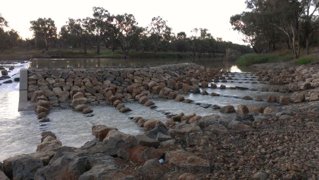
| 1413 - Brewarrina Aboriginal Fish Traps / Baiame's Ngunnhu - Fish ladder constructed in rocks beside weir to allow native fish to swim upstream, completed by NSW Fishers Dept of Primary Industries in 2013 (5051305b5) | |
|---|---|
| Photographer |
B. Hanna |
| Title |
1413 - Brewarrina Aboriginal Fish Traps / Baiame's Ngunnhu - Fish ladder constructed in rocks beside weir to allow native fish to swim upstream, completed by NSW Fishers Dept of Primary Industries in 2013 (5051305b5) |
| Description |
English: Brewarrina Aboriginal Fish Traps: Fish ladder constructed in rocks beside weir to allow native fish to swim upstream, completed by NSW Fishers Dept of Primary Industries in 2013 |
| Depicted place | Brewarrina Aboriginal Fish Traps |
| Source | https://www.environment.nsw.gov.au/maritimeheritageapp/resources/Heritage/shi/505/5051305b5.jpg |
| Permission (Reusing this file) |
This file is licensed under the Creative Commons Attribution 4.0 International license.
|
Licensing
[edit].jpg&action=edit§ion=2)
Copyright State of New South Wales and Office of Environment and Heritage 2019 archive copy at the Wayback Machine
File history
Click on a date/time to view the file as it appeared at that time.
| Date/Time | Thumbnail | Dimensions | User | Comment | |
|---|---|---|---|---|---|
| current | 01:15, 3 May 2019 | | 640 × 361 (82 KB) | Kerry Raymond (talk | contribs) | pattypan 18.02 |
You cannot overwrite this file.
File usage on Commons
The following page uses this file:
.jpg)
.jpg&oldid=743522522)