File:11496488@N07 2180396721.jpg
Original file (7,508 × 6,322 pixels, file size: 8.2 MB, MIME type: image/jpeg)
Captions
Captions
Summary
[edit]
| Description |
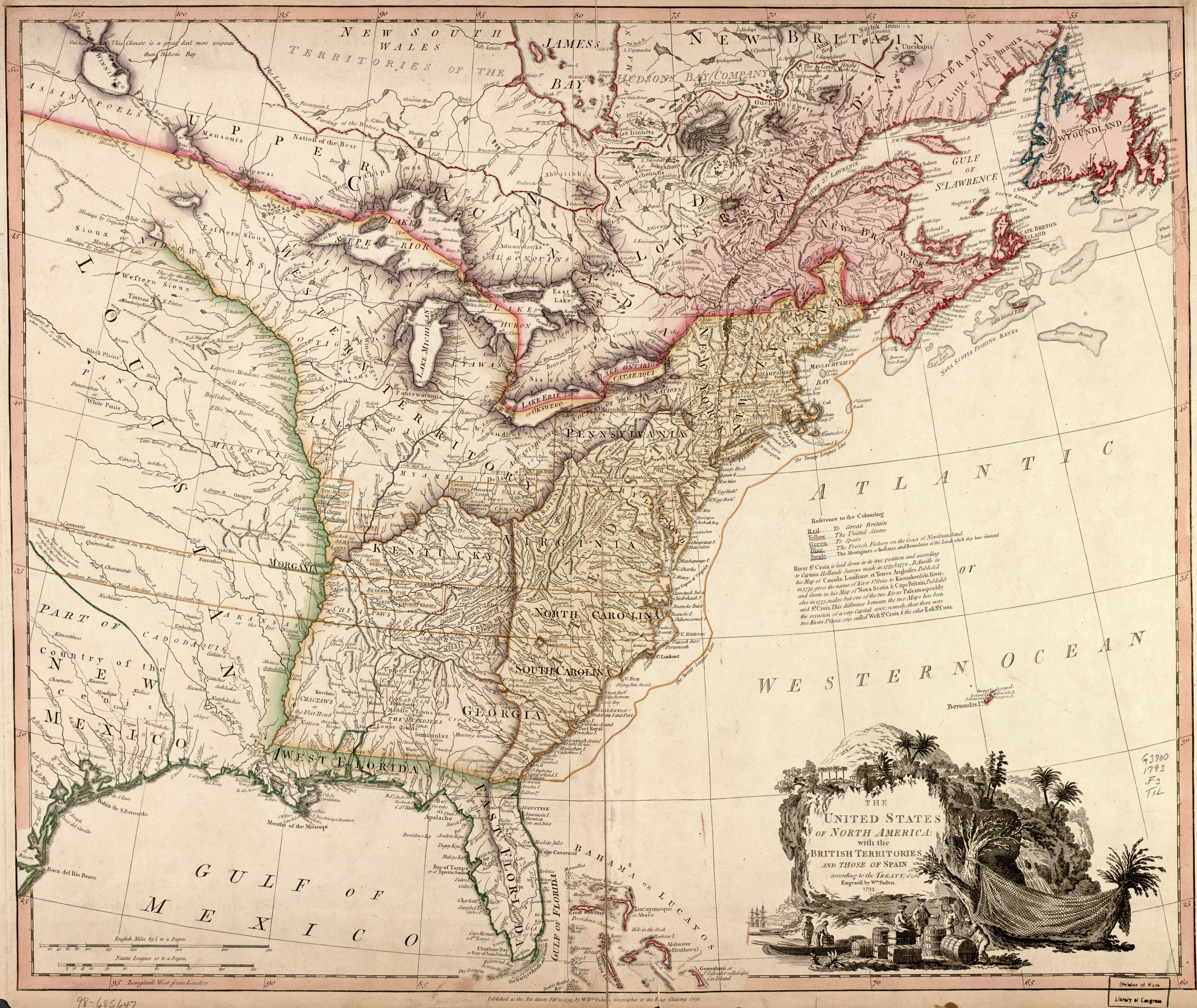
The United Sates of North America (William Faden 1793) Although Aaron Arrowsmith had published several complex maps of North America by 1796, which included the journeys of Hearne, Pond, Mackenzie, Vancouver and many others, numerous prestigious map-making companies were still publishing maps with most of the details of the western regions vestigial remnants nearly a century old. William Faden, the successor of Thomas Jefferys in his cartographic business, published this map which contains the G. De l’Isle version of the Upper Mississippi river, the La Verendrye form of the Border Lakes, and only a modicum of the new configuration of the Albany and Moose river valleys. It will be noted that there exists such relicts as Kik-Kouan river, Monsipi river and the Perray river. But, notwithstanding this, certain new information has been included, notably the postion of the Hudso’s Bay Company’s inland posts in this region. Manitoba does not fare well on this map. (Warkentin and Ruggles. Historical Atlas of Manitoba. map 51, p. 128) The United Sates of North America with the British Territories and those of Span according to the Treaty of 1784, Engrav’d by Wm. Faden 1793 Map drawn by William Faden. Printed in black with coloured portions. Engraved by William Faden. Published in William Faden, General Atlas. London: 1797: No. 46. Image Source: Library of Congress American Memory Project |
| Date | |
| Source | The United Sates of North America (William Faden 1793) |
| Author | Manitoba Historical Maps |
Licensing
[edit]
- You are free:
- to share – to copy, distribute and transmit the work
- to remix – to adapt the work
- Under the following conditions:
- attribution – You must give appropriate credit, provide a link to the license, and indicate if changes were made. You may do so in any reasonable manner, but not in any way that suggests the licensor endorses you or your use.
| This image, originally posted to Flickr, was reviewed on December 14, 2011 by the administrator or reviewer File Upload Bot (Magnus Manske), who confirmed that it was available on Flickr under the stated license on that date. |
File history
Click on a date/time to view the file as it appeared at that time.
| Date/Time | Thumbnail | Dimensions | User | Comment | |
|---|---|---|---|---|---|
| current | 10:40, 14 December 2011 | | 7,508 × 6,322 (8.2 MB) | File Upload Bot (Magnus Manske) (talk | contribs) | {{Information |Description=The United Sates of North America (William Faden 1793) Although Aaron Arrowsmith had published several complex maps of North America by 1796, which included the journeys of Hearne, Pond, Mackenzie, Vancouver and many others, nu |
You cannot overwrite this file.
File usage on Commons
There are no pages that use this file.
File usage on other wikis
The following other wikis use this file:
- Usage on en.wikipedia.org