File:108898 petah tikva hava for agricultural education PikiWiki Israel.jpg
Jump to navigation
Jump to search

Size of this preview: 800 × 450 pixels. Other resolutions: 320 × 180 pixels | 640 × 360 pixels | 1,024 × 576 pixels | 1,280 × 720 pixels | 2,560 × 1,440 pixels.
Original file (2,560 × 1,440 pixels, file size: 1.53 MB, MIME type: image/jpeg)
Captions
Captions
Add a one-line explanation of what this file represents
| Description |
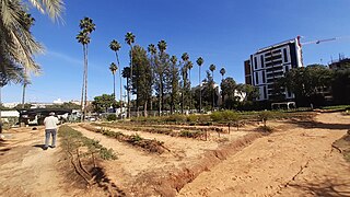
English: Name: Petah Tikva Hava for agricultural education Description: The agricultural farm was founded in 1934 as a district agricultural school, next to the old Kibbutz Givat HaSlosha (today Petah Tikva). Today the farm is used as a heritage site for preservation and as a city school for teaching environmental and agricultural sciences. Yitzhak Rabin's mother, who initiated the idea of the agricultural farm in Petach Tikva, עברית: שם: פתח תקוה חווה לחינוך חקלאי תיאור: החווה החקלאית נוסדה בשנת 1934 כבית ספר חקלאי מחוזי, לצד קיבוץ גבעת השלושה הישן (כיום פתח תקוה). כיום החווה משמשת כאתר מורשת לשימור וכבית ספר עירוני להוראת מדעי הסביבה והחקלאות.אמו של יצחק רבין, שיזמה את רעיון החווה החקלאית בפתח תקוה, הערות: החווה מהווה מרכז לפעילות סביבתית בפתח תקווה, ומהווה משכן למיזמים קהילתיים: צפרות, סיורי מורשת, סיורי טבע וגינון קהילתי.(מיינט) מיקום: קפלן 34 פתח תקוה קובץ מקורי: 20240118_112103.jpg |
| Date | |
| Source | Zalmanson Zeller via the PikiWiki - Israel free image collection project |
| Author | israel zeller ישראל זלר |
| Permission (Reusing this file) |
This file is licensed under the Creative Commons Attribution 2.5 Generic license. Attribution: Zeller Zalmanson Pikiwiki Israel
|

|
This file has been submitted through the Israeli Pikiwiki project and uploaded here automatically.
The project is cooperation between the Israel Internet Association and Wikimedia Israel in an effort to promote the concept of free content on the Web, by creating an image collection of digital-format, good quality photographs, documenting events relating to the history of Israel, or depicting places of distinction in Israel and the Middle East. The Pikiwiki Project is managed from 2021 by the "Heritage Stones" group.
Please consider notifying the project before renaming or deleting this file. Further information about the project can be found on the commons-l mailing list.
|
File history
Click on a date/time to view the file as it appeared at that time.
| Date/Time | Thumbnail | Dimensions | User | Comment | |
|---|---|---|---|---|---|
| current | 00:25, 19 April 2024 | | 2,560 × 1,440 (1.53 MB) | Pikiwikisrael (talk | contribs) |
You cannot overwrite this file.
File usage on Commons
There are no pages that use this file.