File:103 - No. 2 Platform - Great Victoria Street station - 1973 (geograph 3388698).jpg
Jump to navigation
Jump to search
Size of this preview: 800 × 600 pixels. Other resolutions: 320 × 240 pixels | 640 × 480 pixels | 1,024 × 768 pixels.
Original file (1,024 × 768 pixels, file size: 432 KB, MIME type: image/jpeg)
Captions
Captions
Add a one-line explanation of what this file represents
Summary
[edit].jpg&action=edit§ion=1)
| Description |
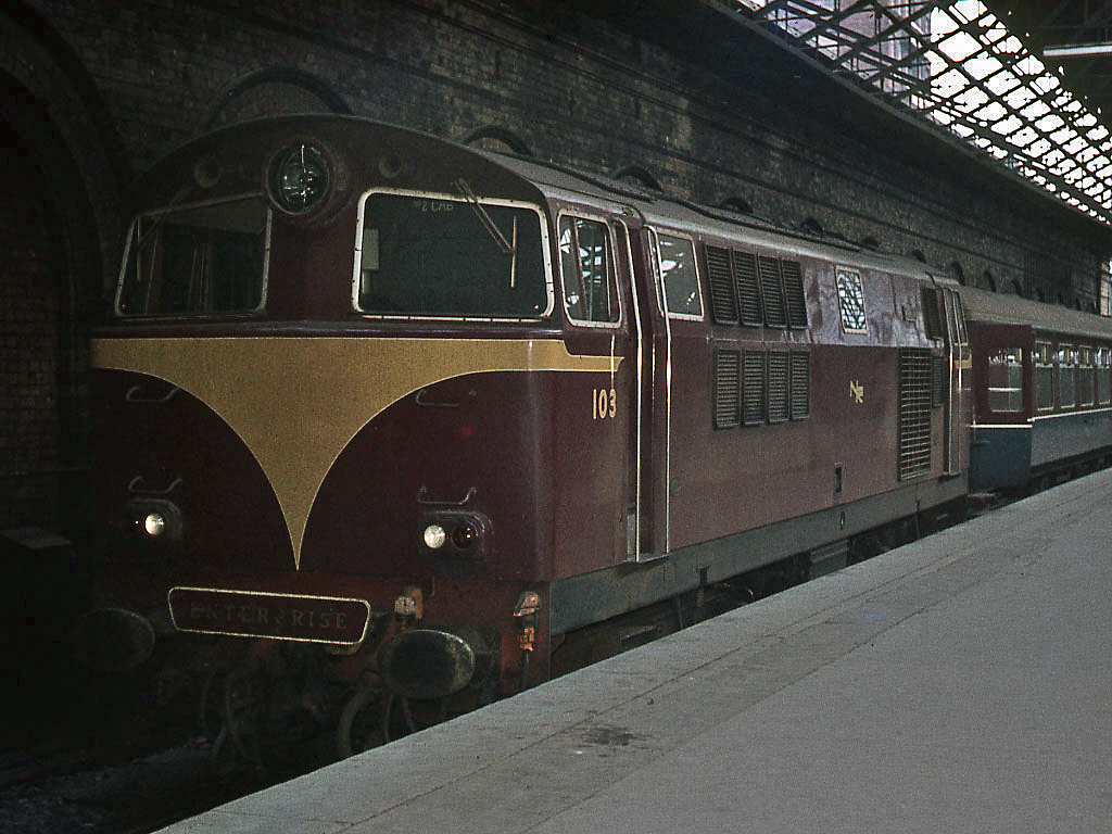
English: 103 - No. 2 Platform - Great Victoria Street station - 1973 103 "Merlin" again, in the dark recesses of No. 2 Platform - which was isolated from the rest of the station to facilitate luggage examination by HM Customs. While 103 has clearly just arrived with probably the 17.30 "Enterprise" from Dublin (Connolly), the date is uncertain. The glassless roof suggests it is after the bomb attack on 27 March 1972 and the photograph is therefore likely taken in 1973. |
| Date | |
| Source | From geograph.org.uk |
| Author | The Carlisle Kid |
| Permission (Reusing this file) |
Creative Commons Attribution Share-alike license 2.0 |
| Attribution (required by the license) | The Carlisle Kid / 103 - No. 2 Platform - Great Victoria Street station - 1973 / |
| Camera location | | View this and other nearby images on: OpenStreetMap |
|---|
.jpg¶ms=054.594108_N_-005.936580_E_globe:Earth_type:camera_source:geograph-irishgrid(J33427372)_heading:90.00&language=en)
| Object location | | View this and other nearby images on: OpenStreetMap |
|---|
.jpg¶ms=054.594110_N_-005.936580_E_globe:Earth_class:object_type:object_source:geograph-irishgrid(J33427372)_heading:90.00&language=en)
Licensing
[edit].jpg&action=edit§ion=2)

|
This image was taken from the Geograph project collection. See this photograph's page on the Geograph website for the photographer's contact details. The copyright on this image is owned by The Carlisle Kid and is licensed for reuse under the Creative Commons Attribution-ShareAlike 2.0 license.
|
This file is licensed under the Creative Commons Attribution-Share Alike 2.0 Generic license.
Attribution: The Carlisle Kid
- You are free:
- to share – to copy, distribute and transmit the work
- to remix – to adapt the work
- Under the following conditions:
- attribution – You must give appropriate credit, provide a link to the license, and indicate if changes were made. You may do so in any reasonable manner, but not in any way that suggests the licensor endorses you or your use.
- share alike – If you remix, transform, or build upon the material, you must distribute your contributions under the same or compatible license as the original.
File history
Click on a date/time to view the file as it appeared at that time.
| Date/Time | Thumbnail | Dimensions | User | Comment | |
|---|---|---|---|---|---|
| current | 14:46, 5 March 2022 | | 1,024 × 768 (432 KB) | Lamberhurst (talk | contribs) | == {{int:filedesc}} == {{Information |Description={{en|1=<b>103 - No. 2 Platform - Great Victoria Street station - 1973</b><br>103 "Merlin" again, in the dark recesses of No. 2 Platform - which was isolated from the rest of the station to facilitate luggage examination by HM Customs. While 103 has clearly just arrived with probably the 17.30 "Enterprise" from Dublin (Connolly), the date is uncertain. The glassless roof suggests it is after the bomb attack on 27 March 1972 and the photograph i... |
You cannot overwrite this file.
File usage on Commons
The following page uses this file:
.jpg&oldid=740514048)