File:1-CABINS.jpg
Original file (3,120 × 4,160 pixels, file size: 6.63 MB, MIME type: image/jpeg)
Captions
Summary
[edit]Description1-CABINS.jpg |
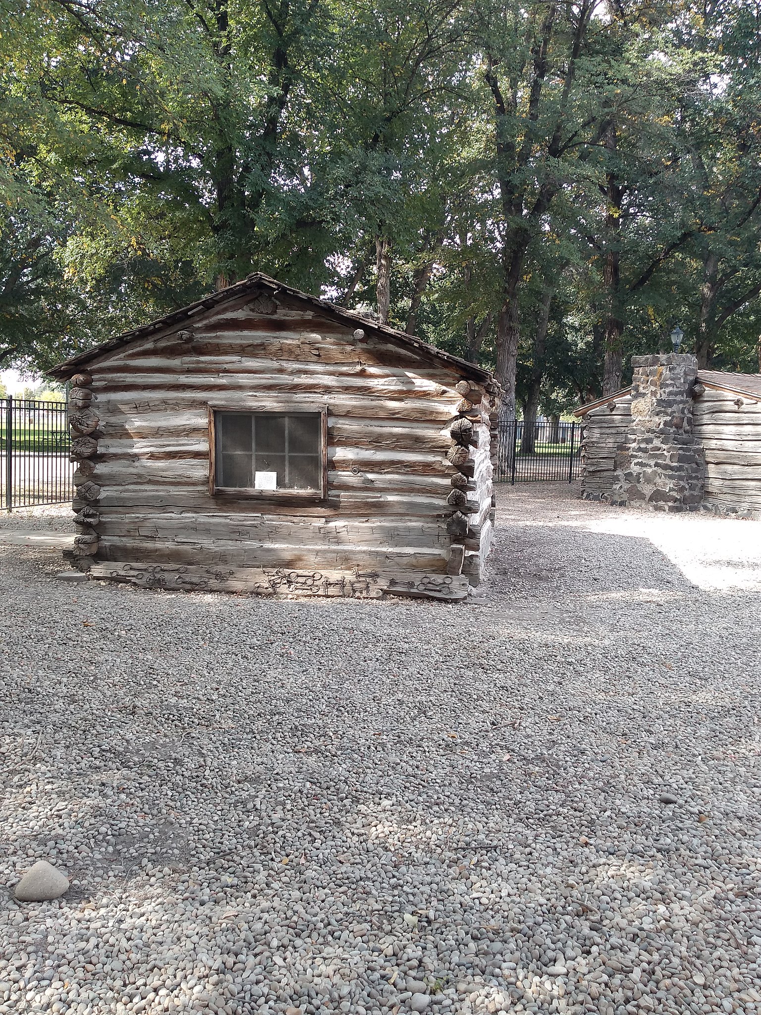
English: The visitors will find two cabins from the Civil War era, a rail car and a wagon from the early twentieth century and vintage agricultural equipment.
This cabins makes the Van Slyke Museum unique. It is an open-air museum that contains artifacts that date back to the days when Idaho was a territory. The native daughters of Idaho relocated the cabins in the park. In recent years, the Caldwell Kiwanis Club ran the museum. That responsibility was recently transferred to the Caldwell Historical Society. The most interesting artefacts oficina the museum maybe are to this two cabins. They were built in 1864 and the descendants of both cottage owners still reside in the Treasure Valley. |
Date | |
Source | Own work |
Author | YRUAMAGLEZ |
Camera location | 43° 39′ 42.88″ N, 116° 41′ 42.68″ W | View this and other nearby images on: OpenStreetMap | 43.661910; -116.695188 |
---|
Licensing
[edit]- You are free:
- to share – to copy, distribute and transmit the work
- to remix – to adapt the work
- Under the following conditions:
- attribution – You must give appropriate credit, provide a link to the license, and indicate if changes were made. You may do so in any reasonable manner, but not in any way that suggests the licensor endorses you or your use.
- share alike – If you remix, transform, or build upon the material, you must distribute your contributions under the same or compatible license as the original.
This image was uploaded as part of Wiki Loves Monuments 2018.
Afrikaans ∙ Alemannisch ∙ العربية ∙ جازايرية ∙ azərbaycanca ∙ Bikol Central ∙ беларуская ∙ беларуская (тарашкевіца) ∙ български ∙ বাংলা ∙ brezhoneg ∙ bosanski ∙ català ∙ čeština ∙ Cymraeg ∙ dansk ∙ Deutsch ∙ Zazaki ∙ Ελληνικά ∙ English ∙ Esperanto ∙ español ∙ eesti ∙ euskara ∙ فارسی ∙ suomi ∙ français ∙ Frysk ∙ Gaeilge ∙ galego ∙ עברית ∙ हिन्दी ∙ hrvatski ∙ magyar ∙ հայերեն ∙ Bahasa Indonesia ∙ Ido ∙ italiano ∙ 日本語 ∙ ქართული ∙ 한국어 ∙ кыргызча ∙ Lëtzebuergesch ∙ latviešu ∙ Malagasy ∙ македонски ∙ മലയാളം ∙ Bahasa Melayu ∙ Malti ∙ norsk bokmål ∙ नेपाली ∙ Nederlands ∙ norsk nynorsk ∙ norsk ∙ polski ∙ português ∙ português do Brasil ∙ română ∙ русский ∙ sicilianu ∙ davvisámegiella ∙ slovenčina ∙ slovenščina ∙ shqip ∙ српски / srpski ∙ svenska ∙ ไทย ∙ Tagalog ∙ Türkçe ∙ українська ∙ اردو ∙ oʻzbekcha / ўзбекча ∙ Yorùbá ∙ 中文 ∙ 中文(中国大陆) ∙ 中文(简体) ∙ 中文(繁體) ∙ 中文(香港) ∙ 中文(臺灣) ∙ +/− |
File history
Click on a date/time to view the file as it appeared at that time.
Date/Time | Thumbnail | Dimensions | User | Comment | |
---|---|---|---|---|---|
current | 21:39, 29 September 2018 | 3,120 × 4,160 (6.63 MB) | YRUAMAGLEZ (talk | contribs) | User created page with UploadWizard |
You cannot overwrite this file.
File usage on Commons
There are no pages that use this file.
Metadata
This file contains additional information such as Exif metadata which may have been added by the digital camera, scanner, or software program used to create or digitize it. If the file has been modified from its original state, some details such as the timestamp may not fully reflect those of the original file. The timestamp is only as accurate as the clock in the camera, and it may be completely wrong.
Camera manufacturer | motorola |
---|---|
Camera model | moto g(6) play |
Exposure time | 1/237 sec (0.0042194092827004) |
F-number | f/2 |
ISO speed rating | 50 |
Date and time of data generation | 12:13, 29 September 2018 |
Lens focal length | 3.519 mm |
Latitude | 43° 39′ 42.88″ N |
Longitude | 116° 41′ 42.68″ W |
Altitude | 722 meters above sea level |
Horizontal resolution | 72 dpi |
Vertical resolution | 72 dpi |
Software used | jeter_sprint-user 8.0.0 OCPS27.91-23-3 3 release-keys |
File change date and time | 12:13, 29 September 2018 |
Y and C positioning | Centered |
Exposure Program | Normal program |
Exif version | 2.2 |
Date and time of digitizing | 12:13, 29 September 2018 |
Meaning of each component |
|
APEX shutter speed | 7.88 |
APEX aperture | 2 |
APEX brightness | −1 |
APEX exposure bias | 0 |
Maximum land aperture | 2 APEX (f/2) |
Metering mode | Center weighted average |
Flash | Flash did not fire, auto mode |
Supported Flashpix version | 1 |
Color space | sRGB |
Scene type | A directly photographed image |
Custom image processing | Normal process |
Exposure mode | Auto exposure |
White balance | Auto white balance |
Digital zoom ratio | 1.12 |
Scene capture type | Standard |
Contrast | Normal |
Saturation | Low saturation |
Sharpness | Soft |
GPS time (atomic clock) | 18:13 |
Geodetic survey data used | WGS-84 |
GPS date | 29 September 2018 |
GPS tag version | 2.2.0.0 |
Structured data
Items portrayed in this file
depicts
29 September 2018
43°39'42.876"N, 116°41'42.677"W
image/jpeg
47c5385d4470a8a9f6765ac1ea1ae39d0601733b
6,949,309 byte
4,160 pixel
3,120 pixel
0.00421940928270042 second
3.519 millimetre
- Files with coordinates missing SDC location of creation
- CC-BY-SA-4.0
- Self-published work
- Images from Wiki Loves Monuments 2018
- Images from Wiki Loves Monuments 2018 in the United States
- Images from Wiki Loves Monuments 2018 in Idaho
- Images from Wiki Loves Monuments missing SDC depicts
- Images from Wiki Loves Monuments missing SDC location of creation
- Wiki Loves Monuments 2018 in the United States unreviewed
- Uploaded via Campaign:wlm-us-other
- Taken with Motorola Moto G6 Play
- United States photographs taken on 2018-09-29