File:0102621 Siddheshwara temple, Siddhanatha, Omkareswar Madhya Pradesh 030.jpg

Original file (1,280 × 960 pixels, file size: 2.42 MB, MIME type: image/jpeg)
Captions
Captions
Summary
[edit]
| Description |
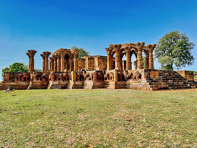
English: The Siddheswar temple, also called Siddhanatha temple, is an 11th-century major Shiva temple on eastern side of the Mandhata island. It is the oldest and largest monument of Omkareshwar, but survives only in its ruined form.
The temple stands on a large jagati (platform), had at least a mukhamndapa, sabhamandapa, antarala and garbhagriya. The sikhara is completely lost, as are the ceilings of the other section. Of what survives, the stones are massive, the mandapa pillars are massive. The sanctum was a 26 feet square, with four entrances and 5 feet antarala on each side. The four entrances each had a doorway, then a sabhamandapa supported by fourteen pillars. Each surviving pillar is 14 feet tall, each sabhamandapa thus a perfect cube. The pillars are intricately carved with squares, polygons, and circles. All are all crowned with bracket capitals, on which the architraves rest, with each bracket carved into a squat human figure. The platform is remarkable, projecting about 12 feet beyond the mandapa, in front of each are a flight of ten steps. It is about ten feet high and appears to be surrounded by an elephant (gaja) frieze carved in almost complete relief on stone slabs. The elephants are about 1.5 meter tall and sculpted from yellow sandstone to exceptional accuracy and attitude. One of their legs rests over a prostrate enemy figure, and they thus reflect an army of victorious elephants. The choice of sandstone has resulted in some weathering. Yet, everywhere there are also signs of deliberate mutilation, with defacement, chopped faces, trunks, ears and similar iconoclasm. Some of the stones and artwork from this temple was extracted out and was reused as masonry. For further scholarly discussions, see (a) Jurgen Neuss (2013), Omkaresvar Mandhata, Tracing the Forgotten History of a Popular Place, Berlin Indological Studies, pp. 115–129; (b) J Forsyth, Mandhata, in The Gazetteer of the Central Provinces of India (editor: Charles Grant), pp. 257–264. |
| Date | |
| Source | Own work |
| Author | Ms Sarah Welch |
| Camera location | | View this and other nearby images on: OpenStreetMap |
|---|
Licensing
[edit]
| This file is made available under the Creative Commons CC0 1.0 Universal Public Domain Dedication. | |
| The person who associated a work with this deed has dedicated the work to the public domain by waiving all of their rights to the work worldwide under copyright law, including all related and neighboring rights, to the extent allowed by law. You can copy, modify, distribute and perform the work, even for commercial purposes, all without asking permission.
|
File history
Click on a date/time to view the file as it appeared at that time.
| Date/Time | Thumbnail | Dimensions | User | Comment | |
|---|---|---|---|---|---|
| current | 03:03, 17 February 2023 | | 1,280 × 960 (2.42 MB) | Ms Sarah Welch (talk | contribs) | Uploaded own work with UploadWizard |
You cannot overwrite this file.
File usage on Commons
The following 2 pages use this file:
File usage on other wikis
The following other wikis use this file:
- Usage on www.wikidata.org