File:-conservationlands15 Social Media Takeover, March 15th, Paleo Bucklet List, McGinnis Canyons NCA in Colorado (16623014928).jpg

Original file (2,500 × 1,667 pixels, file size: 4.88 MB, MIME type: image/jpeg)
Captions
Captions
Summary
[edit].jpg&action=edit§ion=1)
| Description |
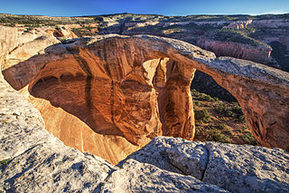
Located in the magnificent red rock country near Grand Junction, Colorado, the McInnis Canyons National Conservation Area offers dinosaur buffs an opportunity to explore sites of significant historic excavations. Step-back 140 million years and hike the 1.5-mile Trail Through Time, an interpretive trail adjacent to an active dinosaur quarry. In addition to learning about past excavations, visitors will occasionally see paleontologists working onsite between May-August. The list of dinosaur remains found here is quite extensive, and includes Apatosaurus, Diplodocus, Brachiosaurus Camarasaurus, Ceratosaurus, Allosaurus, and Nodosaurus. Visitors will find no shortage of outdoor activities in the 123,000-acre NCA. The area includes a hiking trail to the second-largest concentration of natural arches in North America. World-class mountain biking can be found on Mack Ridge and along the 142-mile Kokopelli trail, which extends to Moab, Utah. Twenty-five miles of the Colorado River wind their way through the NCA, offering a flat-water float through spectacular red-rock canyons. Pictograph and petroglyph sites abound, and the Old Spanish Trail - once referred to as the “longest, crookedest, most arduous mule route in the history of America” - runs through the NCA. Photos by Bob WIck, BLM |
| Date | |
| Source | #conservationlands15 Social Media Takeover, March 15th, Paleo Bucklet List, McGinnis Canyons NCA in Colorado |
| Author | Bureau of Land Management |
Licensing
[edit].jpg&action=edit§ion=2)
- You are free:
- to share – to copy, distribute and transmit the work
- to remix – to adapt the work
- Under the following conditions:
- attribution – You must give appropriate credit, provide a link to the license, and indicate if changes were made. You may do so in any reasonable manner, but not in any way that suggests the licensor endorses you or your use.
| This image was originally posted to Flickr by mypubliclands at https://flickr.com/photos/91981596@N06/16623014928. It was reviewed on 4 August 2015 by FlickreviewR and was confirmed to be licensed under the terms of the cc-by-2.0. |
| This image is a work of a Bureau of Land Management* employee, taken or made as part of that person's official duties. As a work of the U.S. federal government, the image is in the public domain in the United States. *or predecessor organization |
File history
Click on a date/time to view the file as it appeared at that time.
| Date/Time | Thumbnail | Dimensions | User | Comment | |
|---|---|---|---|---|---|
| current | 18:58, 4 August 2015 | | 2,500 × 1,667 (4.88 MB) | Wilfredor (talk | contribs) | Transferred from Flickr via Flickr2Commons |
You cannot overwrite this file.
File usage on Commons
The following page uses this file:
File usage on other wikis
The following other wikis use this file:
- Usage on fr.wikipedia.org
- Usage on www.wikidata.org
.jpg&oldid=734663285)