File:-2022-05-28 Footbridge, Bridge Road Marina, Wroxham, Norfolk.jpg
From Wikimedia Commons, the free media repository
Jump to navigation
Jump to search
Size of this preview: 800 × 533 pixels. Other resolutions: 320 × 213 pixels | 640 × 427 pixels | 1,024 × 683 pixels | 1,280 × 853 pixels | 2,560 × 1,706 pixels | 7,789 × 5,192 pixels.
Original file (7,789 × 5,192 pixels, file size: 7.47 MB, MIME type: image/jpeg)
File information
Structured data
Captions
Summary
[edit]Description-2022-05-28 Footbridge, Bridge Road Marina, Wroxham, Norfolk.jpg |
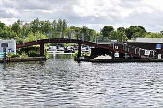
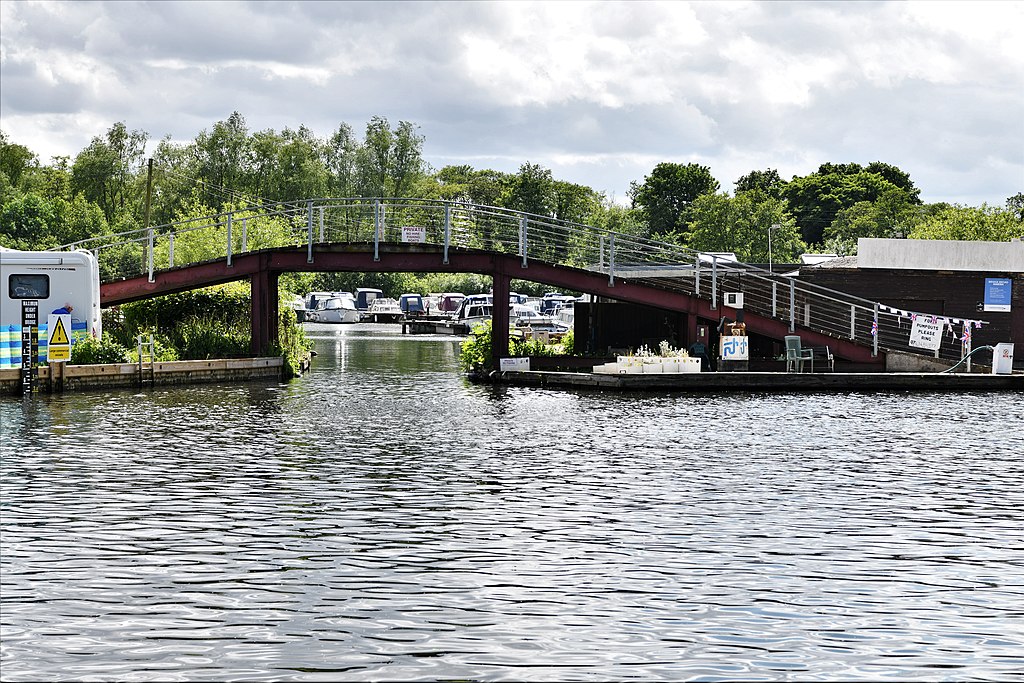
English: A footbridge over the entrance to Bridge Road Marina located in the village of Wroxham, Norfolk, England |
Date | Taken on 28 May 2022 |
Source | From geograph.org.uk |
Author | Michael Garlick |
Attribution (required by the license) InfoField | Michael Garlick / Hoveton: Footbridge / |
InfoField | Michael Garlick / Hoveton: Footbridge |
Object location | 52° 42′ 46.1″ N, 1° 24′ 25.88″ E | View this and other nearby images on: OpenStreetMap | 52.712805; 1.407189 |
---|
Camera location | 52° 42′ 47.44″ N, 1° 24′ 28.76″ E | View this and other nearby images on: OpenStreetMap | 52.713177; 1.407988 |
---|
Licensing
[edit]This image was taken from the Geograph project collection. See this photograph's page on the Geograph website for the photographer's contact details. The copyright on this image is owned by Michael Garlick and is licensed for reuse under the Creative Commons Attribution-ShareAlike 2.0 license.
|
This file is licensed under the Creative Commons Attribution-Share Alike 2.0 Generic license.
Attribution: Michael Garlick
- You are free:
- to share – to copy, distribute and transmit the work
- to remix – to adapt the work
- Under the following conditions:
- attribution – You must give appropriate credit, provide a link to the license, and indicate if changes were made. You may do so in any reasonable manner, but not in any way that suggests the licensor endorses you or your use.
- share alike – If you remix, transform, or build upon the material, you must distribute your contributions under the same or compatible license as the original.
File history
Click on a date/time to view the file as it appeared at that time.
Date/Time | Thumbnail | Dimensions | User | Comment | |
---|---|---|---|---|---|
current | 07:14, 19 June 2022 | 7,789 × 5,192 (7.47 MB) | Geograph Update Bot (talk | contribs) | Higher-resolution version from Geograph | |
07:24, 16 June 2022 | 1,024 × 683 (278 KB) | Kolforn (talk | contribs) | {{Information |Description={{en|1=A footbridge over the entrance to Bridge Road Marina located in the village of {{w|Wroxham}}, Norfolk, England}} |Date={{Taken on|2022-05-28|location=United Kingdom}} |Source=From [https://www.geograph.org.uk/photo/7188222 geograph.org.uk] |author=[https://www.geograph.org.uk/profile/118660 Michael Garlick] |permission= |other_versions= |other fields={{Credit line |Author = Michael Garlick |Other = ''Hoveton: Footbridge'' |License = CC-BY-SA-2.0 }}}} {{O... |
You cannot overwrite this file.
File usage on Commons
There are no pages that use this file.
Metadata
This file contains additional information such as Exif metadata which may have been added by the digital camera, scanner, or software program used to create or digitize it. If the file has been modified from its original state, some details such as the timestamp may not fully reflect those of the original file. The timestamp is only as accurate as the clock in the camera, and it may be completely wrong.
Camera manufacturer | NIKON CORPORATION |
---|---|
Camera model | NIKON D850 |
Exposure time | 1/800 sec (0.00125) |
F-number | f/8 |
ISO speed rating | 320 |
Date and time of data generation | 14:23, 28 May 2022 |
Lens focal length | 70 mm |
Latitude | 52° 42′ 47.45″ N |
Longitude | 1° 24′ 28.78″ E |
Altitude | 10 meters below sea level |
Orientation | Normal |
Horizontal resolution | 300 dpi |
Vertical resolution | 300 dpi |
Software used | Windows Photo Editor 10.0.10011.16384 |
File change date and time | 23:27, 28 May 2022 |
Y and C positioning | Co-sited |
Exposure Program | Aperture priority |
Exif version | 2.31 |
Date and time of digitizing | 14:23, 28 May 2022 |
Meaning of each component |
|
Image compression mode | 1 |
APEX exposure bias | 0 |
Maximum land aperture | 3 APEX (f/2.83) |
Metering mode | Center weighted average |
Light source | Unknown |
Flash | Flash did not fire |
DateTime subseconds | 62 |
DateTimeOriginal subseconds | 62 |
DateTimeDigitized subseconds | 62 |
Supported Flashpix version | 1 |
Color space | sRGB |
Sensing method | One-chip color area sensor |
File source | Digital still camera |
Scene type | A directly photographed image |
Custom image processing | Normal process |
Exposure mode | Auto exposure |
White balance | Auto white balance |
Focal length in 35 mm film | 70 mm |
Scene capture type | Standard |
Scene control | None |
Contrast | Normal |
Saturation | Normal |
Sharpness | Normal |
Subject distance range | Unknown |
GPS time (atomic clock) | 14:24 |
Satellites used for measurement | 13 |
Reference for direction of image | Magnetic direction |
Direction of image | 254.3 |
Geodetic survey data used | WGS 84 |
GPS date | 28 May 2022 |
GPS tag version | 2.3.0.0 |
Rating (out of 5) | 0 |
Structured data
Items portrayed in this file
depicts
28 May 2022
52°42'47.437"N, 1°24'28.757"E
52°42'46.098"N, 1°24'25.880"E
0.00125 second
70 millimetre
320
image/jpeg
8be424ce7cfb07d808ba67e61c4178533ad54856
7,831,723 byte
5,192 pixel
7,789 pixel
Hidden categories:
- United Kingdom photographs taken on 2022-05-28
- Information field template with formatting
- Files with coordinates missing SDC location of creation (52° N, 1° E)
- CC-BY-SA-2.0
- Images from Geograph Britain and Ireland
- Images from Geograph Britain and Ireland missing SDC depicts
- Images from Geograph Britain and Ireland missing SDC creator
- Images from Geograph Britain and Ireland missing SDC source of file
- Images from Geograph Britain and Ireland missing SDC location of creation
- Norfolk images by Michael Garlick