File:(Map of the environs of the Chattahoochee River at Sandtown, Georgia, July 5-17, 1864). LOC 2006459202.jpg
Jump to navigation
Jump to search

Size of this preview: 461 × 600 pixels. Other resolutions: 184 × 240 pixels | 369 × 480 pixels | 590 × 768 pixels | 787 × 1,024 pixels | 1,920 × 2,497 pixels.
Original file (1,920 × 2,497 pixels, file size: 547 KB, MIME type: image/jpeg)
Captions
Captions
Add a one-line explanation of what this file represents
Summary
[edit]| Description |
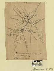
English: Shows area in Cobb County from Powder Springs east to the Chattahoochee River. Title and date from Stephenson's Civil War maps, 1989. Similar to U.S. War Dept.'s Atlas to accompany the official records of the Union and Confederate armies, 1891-95, pl. 45, no. 5. Oriented with north toward the upper left. Pencil. LC Civil War maps (2nd ed.), S53 Available also through the Library of Congress Web site as a raster image. In pencil in bottom right corner: 49. In pencil at bottom: Stoneman. Imperfect: Fold-lined. Mounted on paper. |
||
| Title | [Map of the environs of the Chattahoochee River at Sandtown, Georgia, July 5-17, 1864]. | ||
| Shelf ID | G3923.C73S5 1864 .M3 | ||
| Date | |||
| Source | https://www.loc.gov/item/2006459202/ | ||
| Author | Unknown author | ||
| Permission (Reusing this file) |
|
||
| Other versions |
|
||
| Location | United States · Cobb County · Georgia | ||
| Part of | Military Battles And Campaigns · American Memory · Civil War Maps · Catalog · Geography And Map Division | ||
| Subject | Maps, Manuscript · Georgia · Cobb County (Ga.) · Civil War · United States · Cobb County · History |


._LOC_2006459202.jpg&action=edit§ion=1)
Licensing
[edit]._LOC_2006459202.jpg&action=edit§ion=2)
|
This is a faithful photographic reproduction of a two-dimensional, public domain work of art. The work of art itself is in the public domain for the following reason:
The official position taken by the Wikimedia Foundation is that "faithful reproductions of two-dimensional public domain works of art are public domain".
This photographic reproduction is therefore also considered to be in the public domain in the United States. In other jurisdictions, re-use of this content may be restricted; see Reuse of PD-Art photographs for details. | ||||
File history
Click on a date/time to view the file as it appeared at that time.
| Date/Time | Thumbnail | Dimensions | User | Comment | |
|---|---|---|---|---|---|
| current | 05:22, 8 June 2018 | | 1,920 × 2,497 (547 KB) | Fæ (talk | contribs) | LOC Maps https://www.loc.gov/item/2006459202/ #23484 |
You cannot overwrite this file.
File usage on Commons
The following page uses this file:
._LOC_2006459202.jpg&oldid=734037398)