File:(Map of the Shenandoah Valley from Harrisonburg to Mt. Jackson, with topographical detail along the principal roads from Thornton's Gap to Swift Run Gap and along several valley roads in northwestern LOC 2005625053.jpg
Jump to navigation
Jump to search

Size of this preview: 719 × 600 pixels. Other resolutions: 288 × 240 pixels | 576 × 480 pixels | 921 × 768 pixels | 1,228 × 1,024 pixels | 2,456 × 2,048 pixels | 11,372 × 9,482 pixels.
Original file (11,372 × 9,482 pixels, file size: 14.9 MB, MIME type: image/jpeg)
Captions
Captions
Add a one-line explanation of what this file represents
Summary
[edit]| Warning | The original file is very high-resolution. It might not load properly or could cause your browser to freeze when opened at full size. |
|---|
| Description |
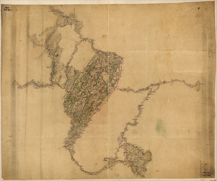
English: Shows names of some residents. Relief shown by form lines and hachures. Title and date from Stephenson's Civil War maps, 1989. Pen-and-ink on tracing linen sectioned in 2, mounted on cloth. LC Civil War maps (2nd ed.), H146 Available also through the Library of Congress web site as raster image. In ink in upper right corner: No. 4. In pencil on verso: 84. |
||
| Title | [Map of the Shenandoah Valley from Harrisonburg to Mt. Jackson, with topographical detail along the principal roads from Thornton's Gap to Swift Run Gap and along several valley roads in northwestern Virginia]. | ||
| Shelf ID | G3882.S52 186- .H6 | ||
| Date | 1860s | ||
| Source | https://www.loc.gov/item/2005625053/ | ||
| Author | Hotchkiss, Jedediah | ||
| Permission (Reusing this file) |
|
||
| Other versions |
|
||
| Location | United States · Shenandoah River Valley · Virginia · West Virginia | ||
| Part of | Hotchkiss Map Collection · Military Battles And Campaigns · Catalog · American Memory · Geography And Map Division | ||
| Subject | Maps, Manuscript · Maps · Virginia · United States · Shenandoah River Valley (Va. And W. Va.) · West Virginia · Shenandoah River Valley · Landowners |


Licensing
[edit]
|
This is a faithful photographic reproduction of a two-dimensional, public domain work of art. The work of art itself is in the public domain for the following reason:
The official position taken by the Wikimedia Foundation is that "faithful reproductions of two-dimensional public domain works of art are public domain".
This photographic reproduction is therefore also considered to be in the public domain in the United States. In other jurisdictions, re-use of this content may be restricted; see Reuse of PD-Art photographs for details. | ||||
File history
Click on a date/time to view the file as it appeared at that time.
| Date/Time | Thumbnail | Dimensions | User | Comment | |
|---|---|---|---|---|---|
| current | 22:05, 23 June 2018 | | 11,372 × 9,482 (14.9 MB) | Fæ (talk | contribs) | LOC Maps https://www.loc.gov/item/2005625053/ #25841 |
You cannot overwrite this file.
File usage on Commons
The following page uses this file: