File:(Map of part of Catoosa, Whitfield, and Walker counties, Georgia). LOC 2006458671.jpg
Jump to navigation
Jump to search

Size of this preview: 435 × 600 pixels. Other resolutions: 174 × 240 pixels | 348 × 480 pixels | 557 × 768 pixels | 743 × 1,024 pixels | 1,486 × 2,048 pixels | 5,152 × 7,102 pixels.
Original file (5,152 × 7,102 pixels, file size: 4.74 MB, MIME type: image/jpeg)
Captions
Captions
Add a one-line explanation of what this file represents
Summary
[edit]| Description |
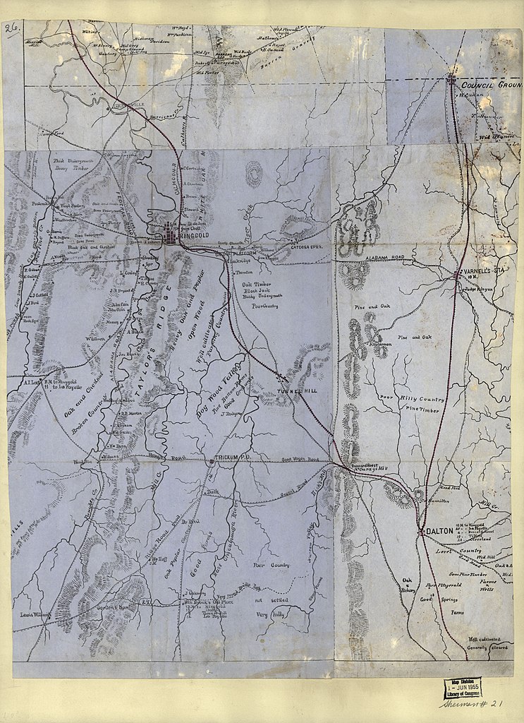
English: Railroads and principal towns are colored red by hand. Relief shown by hachures. Title and date from Stephenson's Civil War maps, 1989. Printed on blue paper. LC Civil War maps (2nd ed.), S21 Available also through the Library of Congress Web site as a raster image. Includes names of select landowners and notes indicating general topography. In upper-left corner: 26. LC copy imperfect: Mounted on paper. |
||
| Title | [Map of part of Catoosa, Whitfield, and Walker counties, Georgia]. | ||
| Shelf ID | G3923.C35 1864 .M3 | ||
| Date | |||
| Source | https://www.loc.gov/item/2006458671/ | ||
| Author | Unknown author | ||
| Permission (Reusing this file) |
|
||
| Other versions |
|
||
| Location | Whitfield County · Walker County · United States · Georgia · Catoosa County | ||
| Part of | Military Battles And Campaigns · American Memory · Civil War Maps · Catalog · Geography And Map Division | ||
| Subject | Georgia · Catoosa County · Walker County (Ga.) · Whitfield County (Ga.) · Catoosa County (Ga.) · United States · Maps · Whitfield County · Walker County · Landowners |


._LOC_2006458671.jpg&action=edit§ion=1)
Licensing
[edit]._LOC_2006458671.jpg&action=edit§ion=2)
|
This is a faithful photographic reproduction of a two-dimensional, public domain work of art. The work of art itself is in the public domain for the following reason:
The official position taken by the Wikimedia Foundation is that "faithful reproductions of two-dimensional public domain works of art are public domain".
This photographic reproduction is therefore also considered to be in the public domain in the United States. In other jurisdictions, re-use of this content may be restricted; see Reuse of PD-Art photographs for details. | ||||
File history
Click on a date/time to view the file as it appeared at that time.
| Date/Time | Thumbnail | Dimensions | User | Comment | |
|---|---|---|---|---|---|
| current | 03:37, 14 June 2018 | | 5,152 × 7,102 (4.74 MB) | Fæ (talk | contribs) | LOC Maps https://www.loc.gov/item/2006458671/ #14830 |
You cannot overwrite this file.
File usage on Commons
The following page uses this file:
._LOC_2006458671.jpg&oldid=920992076)