File:(Map of Henrico County, Va. - showing fortifications around Richmond, north and east of the James River). LOC 2002627451.jpg
Jump to navigation
Jump to search

Size of this preview: 800 × 396 pixels. Other resolutions: 320 × 158 pixels | 640 × 317 pixels | 1,024 × 507 pixels | 1,280 × 634 pixels | 2,560 × 1,268 pixels | 15,710 × 7,781 pixels.
Original file (15,710 × 7,781 pixels, file size: 18.17 MB, MIME type: image/jpeg)
Captions
Captions
Add a one-line explanation of what this file represents
Summary
[edit]| Warning | The original file is very high-resolution. It might not load properly or could cause your browser to freeze when opened at full size. |
|---|
| Description |
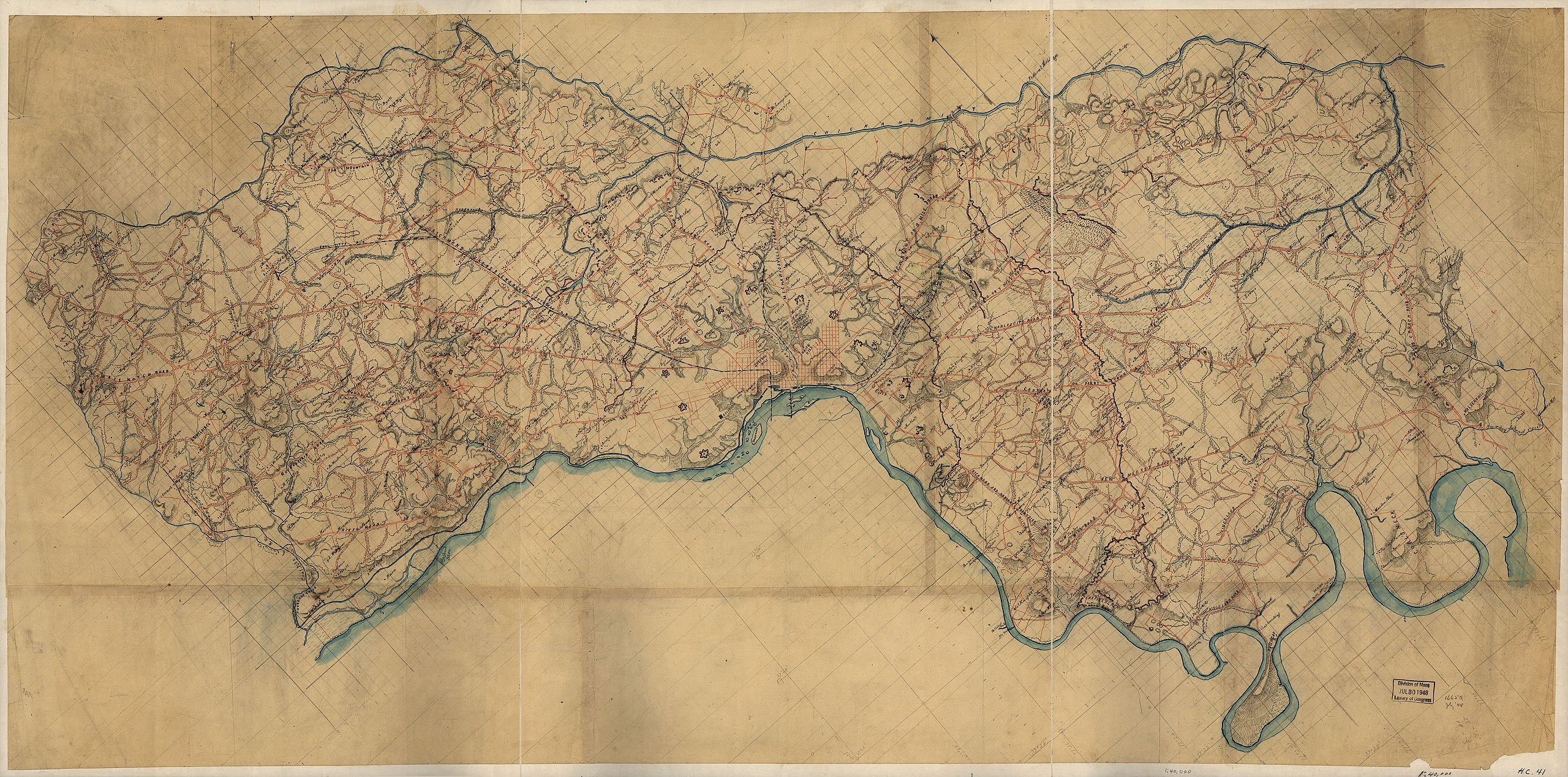
English: LC Land ownership maps, 1281 Shows the names of some residents. Relief shown by hachures. Title and date from Stephenson's Civil War maps, 1989. Drawn on a 3/8-inch pencil grid. Pen-and-ink, pencil, and watercolor on paper composed of many sheets pasted together. Sectioned in 3 and mounted on cloth. LC Civil War maps (2nd ed.), H41 Available also through the Library of Congress web site as raster image. |
||
| Title | [Map of Henrico County, Va. : showing fortifications around Richmond, north and east of the James River]. | ||
| Shelf ID | G3883.H4S5 1864 .M3 | ||
| Date | |||
| Source | https://www.loc.gov/item/2002627451/ | ||
| Author | Unknown author | ||
| Permission (Reusing this file) |
|
||
| Location | Henrico County · United States · Virginia | ||
| Part of | Civil War Maps · County Landownership Maps · Cultural Landscapes · Hotchkiss Map Collection · Military Battles And Campaigns · Catalog · American Memory · Geography And Map Division | ||
| Subject | Maps, Manuscript · Fortification · Virginia · Civil War · United States · Maps · Henrico County (Va.) · Henrico County · Landowners · History |

._LOC_2002627451.jpg&action=edit§ion=1)
._LOC_2002627451.jpg&flash=no)
Licensing
[edit]._LOC_2002627451.jpg&action=edit§ion=2)
|
This is a faithful photographic reproduction of a two-dimensional, public domain work of art. The work of art itself is in the public domain for the following reason:
The official position taken by the Wikimedia Foundation is that "faithful reproductions of two-dimensional public domain works of art are public domain".
This photographic reproduction is therefore also considered to be in the public domain in the United States. In other jurisdictions, re-use of this content may be restricted; see Reuse of PD-Art photographs for details. | ||||
File history
Click on a date/time to view the file as it appeared at that time.
| Date/Time | Thumbnail | Dimensions | User | Comment | |
|---|---|---|---|---|---|
| current | 07:33, 28 August 2018 | | 15,710 × 7,781 (18.17 MB) | Fæ (talk | contribs) | LOC Maps https://www.loc.gov/item/2002627451/ #11168 |
You cannot overwrite this file.
File usage on Commons
There are no pages that use this file.
._LOC_2002627451.jpg&oldid=734036757)