File:(Atlas accompanying An account of expeditions to the sources of the Mississippi and through the western parts of Louisiana to the sources of the Arkansaw, Kans, La Platte, and Pierre Jaun rivers. LOC 77376375-2.jpg
Jump to navigation
Jump to search

Size of this preview: 655 × 599 pixels. Other resolutions: 262 × 240 pixels | 525 × 480 pixels | 839 × 768 pixels | 1,119 × 1,024 pixels | 2,238 × 2,048 pixels | 5,100 × 4,667 pixels.
Original file (5,100 × 4,667 pixels, file size: 3.51 MB, MIME type: image/jpeg)
Captions
Captions
Add a one-line explanation of what this file represents
Summary
[edit]| Description |
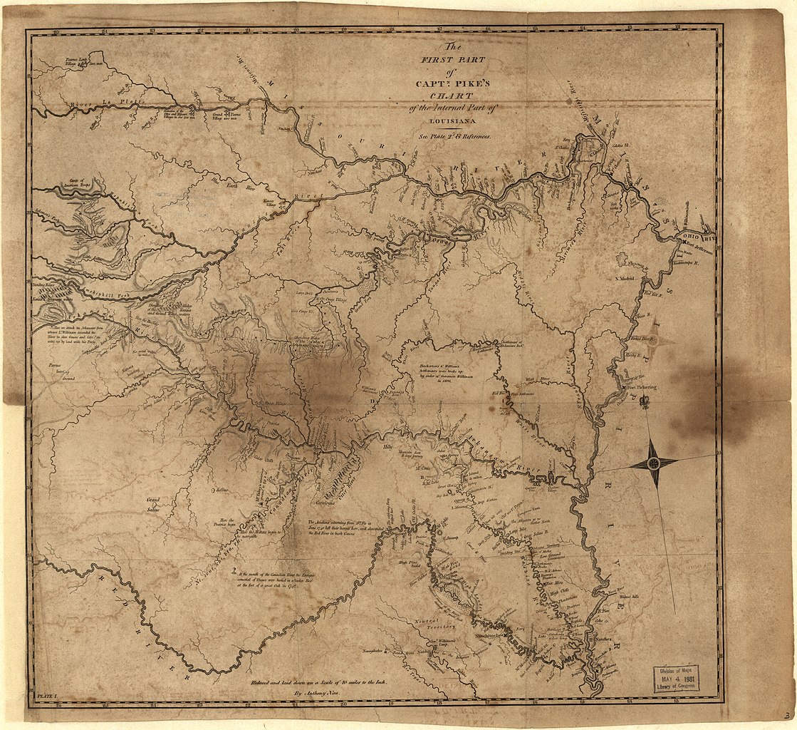
English: "Some copies [of An account] are accompanied by the six maps bound separately." Cf. Sabin 62836. Philips 11024 Copy 1 incomplete: missing all maps, but contains statistical sheets. Copy 2 incomplete: missing Map of Internal Provinces of New Spain. Copy 3 incomplete: missing Map of the Mississippi River. Copy 3 includes "A map of Lewis and Clark's track." Copy 4 incomplete: missing statistical sheets. LC copy 2 has signature of G.K. Warren on front end papers. Available also through the Library of Congress Web site as a raster image. |
||
| Title | [Atlas accompanying An account of expeditions to the sources of the Mississippi and through the western parts of Louisiana to the sources of the Arkansaw, Kans, La Platte, and Pierre Jaun rivers. | ||
| Shelf ID | G1380 .P5 1810 G1380 .P5 1810 Copy 4 | ||
| Parent | https://www.loc.gov/resource/g4050m.gct00017/ | ||
| Sheet title | The First Part of Captn. Pike's Chart of the Internal Part of Louisiana | ||
| Date | |||
| Source | https://www.loc.gov/item/77376375/ | ||
| Author | Pike, Zebulon Montgomery; Warren, G. K. (Gouverneur Kemble) | ||
| Permission (Reusing this file) |
|
||
| Other versions |
|
||
| Location | United States · West · Louisiana · New Mexico · Mississippi River | ||
| Part of | American Memory · Catalog · Louisiana: European Explorations And The Louisiana Purchase · Geography And Map Division · Discovery And Exploration | ||
| Subject | West · West (U.S.) · United States · Maps · New Mexico · Mississippi River · Louisiana · Discovery And Exploration |

Licensing
[edit]
|
This is a faithful photographic reproduction of a two-dimensional, public domain work of art. The work of art itself is in the public domain for the following reason:
The official position taken by the Wikimedia Foundation is that "faithful reproductions of two-dimensional public domain works of art are public domain".
This photographic reproduction is therefore also considered to be in the public domain in the United States. In other jurisdictions, re-use of this content may be restricted; see Reuse of PD-Art photographs for details. | ||||
File history
Click on a date/time to view the file as it appeared at that time.
| Date/Time | Thumbnail | Dimensions | User | Comment | |
|---|---|---|---|---|---|
| current | 22:56, 10 August 2018 | | 5,100 × 4,667 (3.51 MB) | Fæ (talk | contribs) | LOC Maps multisheet https://www.loc.gov/item/77376375/ sheet 2 of 8 #1278 |
You cannot overwrite this file.
File usage on Commons
The following page uses this file: