File:西子灣隧道及其防空設施<1>.jpg
![File:西子灣隧道及其防空設施<1>.jpg](https://upload.wikimedia.org/wikipedia/commons/thumb/a/a0/%E8%A5%BF%E5%AD%90%E7%81%A3%E9%9A%A7%E9%81%93%E5%8F%8A%E5%85%B6%E9%98%B2%E7%A9%BA%E8%A8%AD%E6%96%BD%EF%BC%9C1%EF%BC%9E.jpg/800px-%E8%A5%BF%E5%AD%90%E7%81%A3%E9%9A%A7%E9%81%93%E5%8F%8A%E5%85%B6%E9%98%B2%E7%A9%BA%E8%A8%AD%E6%96%BD%EF%BC%9C1%EF%BC%9E.jpg?20210918031534)
Original file (5,664 × 4,248 pixels, file size: 7.48 MB, MIME type: image/jpeg)
Captions
Captions
Summary
[edit]Description西子灣隧道及其防空設施<1>.jpg |
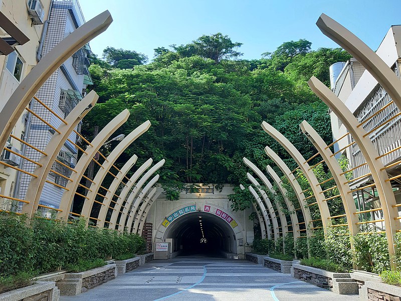
中文(繁體):西子灣隧道又名「壽山洞」,1927年由海野三次郎主持興工,1927年8月貫通;1928年10月竣工。乃是高雄州廳建置壽山公園的規劃設施之一。隧道全長260公尺、寬6公尺、高3.6公尺,隧道兩端入口以混凝土澆製成仿石砌拱圈,並連通景色優美的西子灣和當時高雄市的政經中心--湊町(今日的哈瑪星)。壽山洞開放通行後,人們不必再繞行哨船頭就可以穿越壽山洞進入壽山公園、壽山海水浴場,大幅縮短路程。對外地遊客而言,壽山洞彷如發現觀光名勝的時光隧道;對高雄新市街的住民來說,壽山洞則是暫離繁忙工商生活的過渡地帶。二次世界大戰末期,美軍轟炸時曾改作防空洞使用,至今保存良好。 |
Date | |
Source | Own work |
Author | WEI, WAN-CHEN(魏琬臻) |
Camera location | 22° 37′ 28″ N, 120° 16′ 10″ E ![]() | View this and other nearby images on: OpenStreetMap | ![]() |
---|
Licensing
[edit]![w:en:Creative Commons](https://upload.wikimedia.org/wikipedia/commons/thumb/7/79/CC_some_rights_reserved.svg/90px-CC_some_rights_reserved.svg.png)
![attribution](https://upload.wikimedia.org/wikipedia/commons/thumb/1/11/Cc-by_new_white.svg/24px-Cc-by_new_white.svg.png)
![share alike](https://upload.wikimedia.org/wikipedia/commons/thumb/d/df/Cc-sa_white.svg/24px-Cc-sa_white.svg.png)
- You are free:
- to share – to copy, distribute and transmit the work
- to remix – to adapt the work
- Under the following conditions:
- attribution – You must give appropriate credit, provide a link to the license, and indicate if changes were made. You may do so in any reasonable manner, but not in any way that suggests the licensor endorses you or your use.
- share alike – If you remix, transform, or build upon the material, you must distribute your contributions under the same or compatible license as the original.
![]() |
This image was uploaded as part of Wiki Loves Monuments 2021.
Afrikaans ∙ Alemannisch ∙ azərbaycanca ∙ Bahasa Indonesia ∙ Bahasa Melayu ∙ Bikol Central ∙ bosanski ∙ brezhoneg ∙ català ∙ čeština ∙ Cymraeg ∙ dansk ∙ davvisámegiella ∙ Deutsch ∙ eesti ∙ English ∙ español ∙ Esperanto ∙ euskara ∙ français ∙ Frysk ∙ Gaeilge ∙ galego ∙ hrvatski ∙ Ido ∙ italiano ∙ latviešu ∙ Lëtzebuergesch ∙ Malagasy ∙ magyar ∙ Malti ∙ Nederlands ∙ norsk ∙ norsk nynorsk ∙ norsk bokmål ∙ polski ∙ português ∙ português do Brasil ∙ română ∙ shqip ∙ sicilianu ∙ slovenčina ∙ slovenščina ∙ suomi ∙ svenska ∙ Tagalog ∙ Türkçe ∙ Yorùbá ∙ Zazaki ∙ Ελληνικά ∙ беларуская ∙ беларуская (тарашкевіца) ∙ български ∙ кыргызча ∙ македонски ∙ русский ∙ српски / srpski ∙ українська ∙ ქართული ∙ հայերեն ∙ नेपाली ∙ हिन्दी ∙ বাংলা ∙ മലയാളം ∙ ไทย ∙ 한국어 ∙ +/− |
![]() |
File history
Click on a date/time to view the file as it appeared at that time.
Date/Time | Thumbnail | Dimensions | User | Comment | |
---|---|---|---|---|---|
current | 03:15, 18 September 2021 | ![]() | 5,664 × 4,248 (7.48 MB) | WEI, WAN-CHEN (talk | contribs) | Uploaded own work with UploadWizard |
You cannot overwrite this file.
File usage on Commons
There are no pages that use this file.
Metadata
This file contains additional information such as Exif metadata which may have been added by the digital camera, scanner, or software program used to create or digitize it. If the file has been modified from its original state, some details such as the timestamp may not fully reflect those of the original file. The timestamp is only as accurate as the clock in the camera, and it may be completely wrong.
Camera manufacturer | samsung |
---|---|
Camera model | SM-A750GN |
Date and time of data generation | 14:51, 17 September 2021 |
Exposure time | 1/540 sec (0.0018518518518519) |
F-number | f/1.7 |
ISO speed rating | 40 |
Lens focal length | 3.93 mm |
Latitude | 22° 37′ 28″ N |
Altitude | 49 meters above sea level |
Longitude | 120° 16′ 10″ E |
Height | 4,248 px |
Orientation | 0 |
File change date and time | 23:57, 17 September 2021 |
Vertical resolution | 72 dpi |
Horizontal resolution | 72 dpi |
Width | 5,664 px |
Software used | A750GNDXU5CTC5 |
Y and C positioning | Centered |
APEX aperture | 1.53 |
Scene type | A directly photographed image |
Exif version | 2.2 |
APEX exposure bias | 0 |
Exposure Program | Normal program |
Unique image ID | B24LSLF01AM B24LSNC04AA |
Color space | sRGB |
Maximum land aperture | 1.53 APEX (f/1.7) |
APEX brightness | 7.21 |
Supported Flashpix version | 1 |
DateTimeOriginal subseconds | 0263 |
White balance | Auto white balance |
Custom image processing | Normal process |
Exposure mode | Auto exposure |
Flash | Flash did not fire |
DateTime subseconds | 0263 |
Saturation | Normal |
Meaning of each component |
|
Focal length in 35 mm film | 27 mm |
DateTimeDigitized subseconds | 0263 |
Sharpness | Normal |
Contrast | Normal |
Date and time of digitizing | 14:51, 17 September 2021 |
APEX shutter speed | 10.07 |
Metering mode | Spot |
Scene capture type | Standard |
Light source | Unknown |
GPS time (atomic clock) | 06:51 |
GPS date | 17 September 2021 |
GPS tag version | 2.2.0.0 |
Structured data
Items portrayed in this file
depicts
some value
22°37'27.998"N, 120°16'9.998"E
0.00185185185185185185 second
1.7
3.93 millimetre
17 September 2021
image/jpeg
- Files with coordinates missing SDC location of creation
- CC-BY-SA-4.0
- Self-published work
- Images from Wiki Loves Monuments 2021
- Images from Wiki Loves Monuments 2021 in Taiwan
- Images from Wiki Loves Monuments missing SDC depicts
- Images from Wiki Loves Monuments missing SDC location of creation
- Uploaded via Campaign:wlm-tw
- Photographs by WEI, WAN-CHEN
- Pages with maps