File:美福大排.jpg
Jump to navigation
Jump to search

Size of this preview: 800 × 450 pixels. Other resolutions: 320 × 180 pixels | 640 × 360 pixels | 1,024 × 576 pixels | 1,280 × 720 pixels | 2,560 × 1,440 pixels | 4,437 × 2,496 pixels.
Original file (4,437 × 2,496 pixels, file size: 4.31 MB, MIME type: image/jpeg)
Captions
Captions
Add a one-line explanation of what this file represents
Summary
[edit]
| Description |
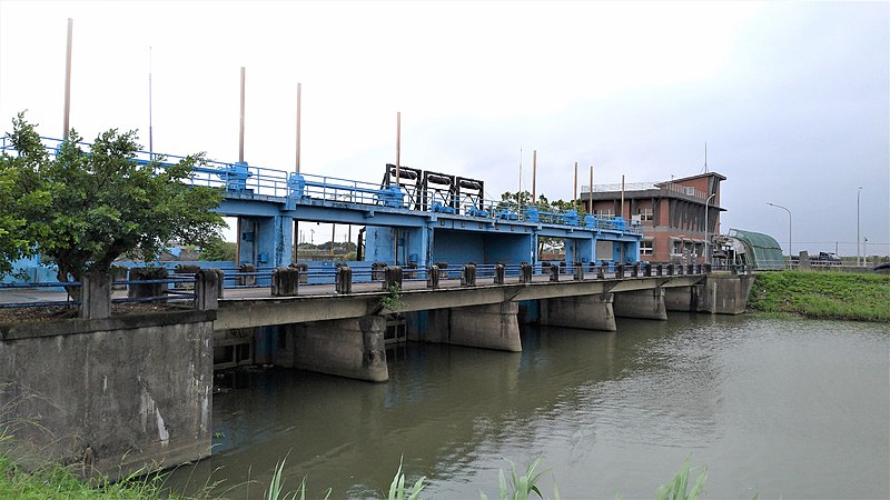
中文(臺灣): 美福大排,為宜蘭市南區重要的排水河道,長度10,566公尺,容許排水能力每秒101.14立方公尺。早先堤岸髒亂、雜草叢生,水質汙染嚴重,近幾年經宜蘭縣政府及鄉公所整頓河道、綠美化堤岸,使美福大排煥然一新。
舊稱「大港」,其歷史背景悠久可追溯至清代,位於蘭陽平原最中心的農業區域。大排跨域極廣,從宜蘭至壯圍,全程各層級水文地景豐富,包含溪、河、大排、渠道、平行水道、閘門、抽水站、鳥類棲息地、水邊聚落等。 大排水源自宜蘭河支流大湖溪,從宜蘭市運動公園西北邊,穿過鐵路向東南流過壯圍鄉,在新南村尾注入宜蘭河。宜蘭、壯圍兩市鄉農民耕作,皆仰賴此條灌溉排水系統,為溪北南岸帶來良田無數。但位處下游地段的壯圍鄉,地勢低窪地區,每逢連續豪雨,承受著來自於大同、員山、宜蘭等地區雨水大量流入,十三股及美福兩大排水系統,因海平面與內地微小落差,而無法有效發揮排洪功能,導致宣洩不及,暴雨時常造成多處淹水情形(古亭、新社、新南、美福、古結)。 |
| Source | https://memory.culture.tw/Home/Detail?Id=602929&IndexCode=Culture_Place |
| Author | 創作者:莊文生;鐘碧娟;徐永昶。貢獻者:宜蘭縣政府文化局 |
| Camera location | | View this and other nearby images on: OpenStreetMap |
|---|
Licensing
[edit]
This file is licensed under the Creative Commons Attribution 3.0 Taiwan license.
- You are free:
- to share – to copy, distribute and transmit the work
- to remix – to adapt the work
- Under the following conditions:
- attribution – You must give appropriate credit, provide a link to the license, and indicate if changes were made. You may do so in any reasonable manner, but not in any way that suggests the licensor endorses you or your use.

File history
Click on a date/time to view the file as it appeared at that time.
| Date/Time | Thumbnail | Dimensions | User | Comment | |
|---|---|---|---|---|---|
| current | 04:45, 14 April 2022 | | 4,437 × 2,496 (4.31 MB) | Muyueh Bot (talk | contribs) |
You cannot overwrite this file.
File usage on Commons
There are no pages that use this file.